
Home » Posts tagged 'operations'
Tag Archives: operations
#GRX GreenX Metals LTD – GreenX Uncovers Historical Estimate at Tannenberg
HIGHLIGHTS
· 1940 Historical Estimate of Significant Scale: Historical Estimate from 1940 identifies 728,000 tonnes contained copper (1,605 Mlbs) at an average grade of 2.6% copper in part of Tannenberg Project licence area discovered from original project data archives
o Estimate based on a 1935-1938 National Socialist Government drilling campaign across four zones: Ronshausen, Hönebach, Wolfsberg and Schnepfenbusch
o Drilling targeted the thin Kupferschiefer horizon only
o Focused only on copper and did not include by-product metals
· 1984 Historical Estimate provides Validation: Independent company St Joe Exploration GmbH conducted limited drilling between 1980 and 1984, further validating the 1940 historical estimate
o Drilling focused on only 28% of the Ronshausen zone but included by-product silver
o Drilling identified up to 3.45m thick mineralisation straddling the Kupferschiefer and the limestone hanging wall and sandstone footwall above and below the Kupferschiefer
o 1984 historical estimate shows consistent grades of 2.1% copper plus 25 g/t silver with 169,000 tonnes of contained copper and 6.5 million ounces of silver
· Exploration Upside Potential under Modern Interpretation: St Joe Exploration confirmed thicker widths of copper and silver mineralisation at Ronshausen, and more may exist up to 30m above and 60m below the Kupferschiefer in the limestone hanging wall and sandstone footwall
o Hypothesis is consistent with modern understanding of the Kupferschiefer deposit model as demonstrated at KGHM’s Polish mining operations which are also found on the same geological structure as the Tannenberg Project
· Active Exploration Program: GreenX is currently relogging and resampling over 4km of archived core from 47 holes to upgrade historical data to modern standards
o Investigation of German mining archives and the digitisation of original historical data continues
o Planning of future twin drilling campaign to verify the historical estimates, and to establish a mineral resource estimate in accordance with the JORC Code (2012) (JORC Code)
· Cautionary statement: The historical estimates in this announcement are not reported in accordance with the JORC Code. A competent person has not done sufficient work to classify the historical estimate as a mineral resource or ore reserve in accordance with the JORC Code. It is uncertain that following evaluation and/or further exploration work that the historical estimate will be able to be reported as a mineral resource or ore reserve in accordance with the JORC Code.
GreenX Metals Limited (ASX:GRX, LSE:GRX, GPW:GRX, Germany-FSE:A3C9JR) (GreenX or Company) is pleased to announce that through its ongoing search of original archive data, the Company has identified a historical estimate of 728,000 contained tonnes of copper (1,605 Mlbs) at an average grade of 2.6% Cu from the Tannenberg Copper Project (Tannenberg or Project) dating from 1940 (1940 historical estimate). The 1940 historical estimate was produced by the German company Mansfeldsche Kupferschieferbergbau AG (Mansfeld AG) and is based on the 95-drill hole exploration campaign carried out during the late 1930s (refer to announcement dated 11 September 2025).
In addition, a later historical estimate from 1984 was produced by St Joe Exploration GmbH (St Joe), which covers a small part of the same area as the 1940 historical estimate (St Joe’s historical estimate).
The St Joe’s historical estimate is based on limited drilling between 1980 and 1984 (refer to announcements dated 2 August 2024 and 28 April 2025). St Joe’s historical estimate provides further validation for the 1940s historical estimate.
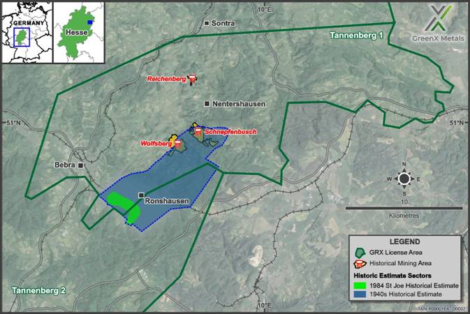
Figure 1: Map showing the location of the zones of the historical estimates and historical mining operations
GreenX’s Chief Executive Officer, Mr Ben Stoikovich, commented: “This represents a significant breakthrough in our archive search and fundamentally supports our exploration hypothesis of the Tannenberg mineral system. It demonstrates that extensive copper mineralisation was identified historically, but exploration at the time was constrained by the prevailing geological model, which focused solely on the thin Kupferschiefer shale and the urgent need to mine given the outbreak of World War II. The 1940 historical estimate, based on a narrow-mineralised interval and excluding by-product silver, was further validated by the 1984 work and modern understanding from Poland’s Kupferschiefer mining operations, together confirming that copper mineralisation extends beyond the Kupferschiefer horizon and providing major proof of concept and clear alignment with GreenX’s geological model. The implications are substantial, reinforcing the potential for a large-scale and high-grade brownfield copper project at Tannenberg, and underscoring the project’s significance as a major European copper opportunity.”
1940 MANSFELD HISTORICAL ESTIMATE
The 1940 historical estimate was calculated by Mansfeld AG according to the relevant German standards applicable during that time. The 1940 historical estimate is based on 18 holes from the 95-hole database generated during the 1935 to 1938 drilling campaign. The original archive document established 728,000 tonnes of contained copper at an average grade of 2.6% copper between the Wolfsberg and Schnepfenbusch mines in the North and the Ronshausen area in the South (Figure 2). The historical estimate covers mineralisation from a depth of 100m in the North to 400m in the Southern end area near Ronshausen.
The 1940 historical estimate covers only the narrow width Kupferschiefer shale mineralisation, which is notable due to the mistaken belief at the time that copper was only present in the distinctive Kupferschiefer shale. Later exploration campaigns have found mineralisation over much wider thicknesses (see 1984 St Joe’s historical estimate section below). This is consistent with GreenX’s exploration hypothesis that historical exploration was mainly based on an outdated deposit model that focused on the 20-60 cm-thick Kupferschiefer shale horizon. The modern understanding of the Kupferschiefer deposit model now shows that up to 95% of mineable copper can be hosted in the footwall sandstone and hanging wall limestone, as evidenced at KGHM Polska Miedź S.A’s Polish mining operations.
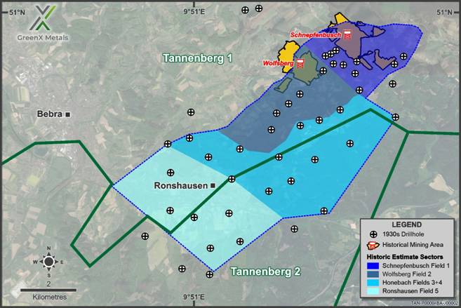
Figure 2: Map showing the locations of the zones of the 1940 historical estimate, related drill holes and historical mining operations
It is also noteworthy that the 1940 historical estimate did not include by-product silver mineralisation. The majority of the mineralisation (463,000 tonnes of contained copper) was found to be present in the Ronshausen region, with gradually decreasing amounts to the North, where the historical mining is to be found (See Table 1).
|
Table 1: Summary of Historical Estimate information from the original 1940 Mansfeld report |
||||
|
Zone |
Surface Area |
Thickness (cm) |
Grade Cu |
Contained Copper |
|
Ronshausen |
10,000,000 |
67.4 |
2.85 |
463,000 |
|
Hönebach |
8,088,000 |
34.2 |
1.92 |
130,055 |
|
Wolfsberg |
6,468,000 |
23.5 |
2.35 |
92,945 |
|
Schnepfenbusch |
5,528,000 |
19.3 |
2.38 |
65,673 |
|
SUB-TOTAL |
|
|
2.59 |
751,673 |
|
Less historical production |
(23,793) |
|||
|
TOTAL |
|
|
|
727,880 |
Cautionary statement: The historical estimates in this announcement are not reported in accordance with the JORC Code. A competent person has not done sufficient work to classify the historical estimate as a mineral resource ore reserve in accordance with the JORC Code. It is uncertain that following evaluation and/or further exploration work that the historical estimate will be able to be reported as a mineral resource ore reserve in accordance with the JORC Code.
The 1940 historical estimate data provides a good level of transparency with regard to the input data and the calculation methods used. The estimation resulting from the drill hole data was cross-checked by Mansfeld AG against the production grades at the Wolfsberg and Schnepfenbusch mines, which were operating in the area at the time of 1940 historical estimate. The comparison was favourable, and hence the assays from the exploration holes were used. GreenX has reviewed original records covering 17 of the 18 holes (~95%) used for the historical estimation and found no discrepancies.
Mansfeld AG made specific adjustments as part of the 1940 historical estimate to account for sterilisation. A total of 250,000 tonnes of contained copper was omitted to account for areas where surface features might prevent mining. Mansfeld AG also estimated that a further 23,793 tonnes of contained copper had already been extracted by mining at Wolfsberg and Schnepfenbusch (at a production grade of 2.2% Copper). This amount was then subtracted from the historical estimate, as presented in the original source document (refer Table 1 above).
1984 ST JOE’S HISTORICAL ESTIMATE
Part of the Ronshausen zone of the 1940 historical estimate was drilled by St Joe Exploration during the 1980’s, resulting in recognition of the St Joe’s historical estimate more than 40 years later. Of the many holes drilled by St Joe, a total of 14 holes were used in the estimate of 169,000 of contained copper and 6.5 million ounces of contained silver. The St Joe’s work estimated grades of 2.1 % copper and 25 g/t silver at typical depths between 290 and 370m (Figure 3).
St Joe benefited from both technological advancements and enhanced geological understanding in the 40 years following the work by Mansfeld AG. Consequently, St Joe assayed wider intersections and found that the mineralisation was up to 3.45m width. The historical estimate was calculated using thicknesses of between 1.5 to 2m, considerably thicker than the narrow Kupferschiefer assayed and estimated by Mansfeld AG in 1940.
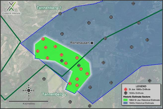
Figure 3: Map showing the drill holes and locations of the Ronshausen zone of the 1940 historical estimate and the relative location of the 1984 St Joe’s historical estimate
Given the increased mineralisation thickness covered by St Joe and the fact that the drilling covered only 28% of the Ronshausen zone, the St Joe’s historical estimate further validates the 1940 historical estimate. The identification of much thicker mineralisation and contained silver also points to considerable exploration upside over all five mineralisation zones covered by the 1940 historical estimate.
Cautionary statement: The historical estimates in this announcement are not reported in accordance with the JORC Code. A competent person has not done sufficient work to classify the historical estimate as a mineral resource or ore reserve in accordance with the JORC Code. It is uncertain that following evaluation and/or further exploration work that the historical estimate will be able to be reported as a mineral resource or ore reserve in accordance with the JORC Code.
1930s DRILLING CAMPAIGN
The 18 holes used in the 1940 historical estimate were drilled between 1935 and 1938 (Figure 4). The southern holes tested the downdip continuation of known Kupferschiefer mining sites from the mid-1800s and led to the opening of the Wolfsberg and Schnepfenbusch mines. In the northern area, the drilling discovered previously unknown down-faulted Kupferschiefer that does not outcrop and had not been previously exploited. This discovery led to the opening of the Reichenberg mine.
GreenX recently found the majority of the relevant original records of these drill holes in a regional archive. To date, of the 95 holes indicated to exist in the 1930s database, the Company has found logs for 43 holes, and of those, original historical assay results have been found for 35 holes. GreenX is continuing the archive search whilst digitising the records to add to the geological database for the Project.
Drilling up to 95 holes today is estimated to cost over €25 million and take several years, given modern permitting requirements. The discovery of the original historical drill database and 1940 historical estimate not only represents a significant saving in both time and money for GreenX, but it also provides valuable data points for its current exploration work program, including exploration targeting and 3D modelling. Combined with the 47 drill cores GreenX is currently re-logging and sampling (Figure 4), the quantity of previous exploration data available at Tannenberg is quickly growing, and underscores Tannenberg as a significant brownfield exploration opportunity.
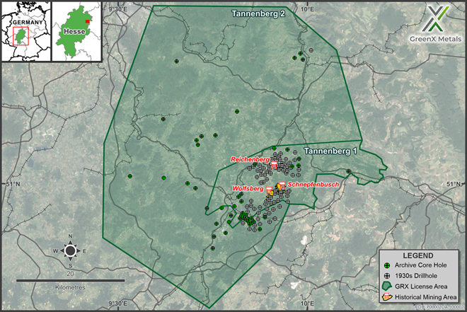
Figure 4: Location Map of GreenX’s Tannenberg project area showing the newly discovered 95 x 1930s drillholes, the location of the three underground copper/ silver mines opened during the late 1930s, and the location of the modern era 47 archive core holes that GreenX now has access to for re-logging and sampling
Upcoming Work Programs
The discovery of this historical estimate and the National Socialist era drill database is part of the Company’s continued search for original historical mining and production data in German archives, which are part of a broader exploration program at Tannenberg, which includes:
· Logging, assaying, and hyperspectral scanning of historical core (ongoing);
· Reprocessing and analysis of historical geophysical data (ongoing);
· Collation of historical geological, mine development, and production data (ongoing); and
· Airborne magnetic and radiometric survey (results released in September 2025)
In light of the discovery of this significant upgrade in the understanding of the Tannenberg mineralisation, GreenX is planning a future twin drilling campaign to verify the historical estimates, in order to establish a mineral resource estimate in accordance with the JORC Code.
ENQUIRIES
|
+44 207 478 3900 ir@greenxmetals.com |
Sapan Ghai Chief Commercial Officer – UK
|
|
Kim Eckhof Investor Relations – UK / Germany
|
Kazimierz Chojna Investor Relations – Poland
|
Competent Person Statement – HISTORICAL Estimate
The information in this announcement that relates to historical estimates is based on information reviewed and compiled by Dr Matt Jackson, a Competent Person who is a member of the Australian Institute of Mining and Metallurgy. Dr Jackson is a Technical Consultant for GreenX and is a holder of unlisted options in the Company. Dr Jackson has sufficient experience that is relevant to the style of mineralisation and type of deposit under consideration and to the activity being undertaken, to qualify as a Competent Person as defined in the 2012 Edition of the ‘Australasian Code for Reporting of Exploration Results, Mineral Resources and Ore Reserves’. Dr Jackson consents to the inclusion in this announcement of the matters based on his information in the form and context in which it appears. Dr Jackson confirms that the information provided under ASX Listing Rules 5.12.2 to 5.12.7 is an accurate representation of the available data and studies relating to the Tannenberg Copper Project.
Forward Looking Statements
This release may include forward-looking statements, which may be identified by words such as “expects”, “anticipates”, “believes”, “projects”, “plans”, and similar expressions. These forward-looking statements are based on GreenX’s expectations and beliefs concerning future events. Forward looking statements are necessarily subject to risks, uncertainties and other factors, many of which are outside the control of GreenX, which could cause actual results to differ materially from such statements. There can be no assurance that forward-looking statements will prove to be correct. GreenX makes no undertaking to subsequently update or revise the forward-looking statements made in this release, to reflect the circumstances or events after the date of that release.
The information contained within this announcement is deemed to constitute inside information as stipulated under the Regulation 2014/596/EU which is part of domestic law pursuant to the Market Abuse (Amendment) (EU Exit) Regulations (SI 2019/310) (“UK MAR”). By the publication of this announcement via a Regulatory Information Service, this inside information (as defined in UK MAR) is now considered to be in the public domain.
REFERENCES
Mansfeldsche Kupferschieferbergbau AG. (1940). On the development of the Richelsdorf area. In German. State archive of Saxony Anhalt Region (Merseburg)*
St Joe Exploration GMBH. (1984) A Final report on the activities of St Joe Explorations GMBH in the Kupferschiefer project, Richelsdorf 1984. Archive No 17. PO BOX, 5780, 3000 Hannover 1.*
*English translation of the original source document
SCHEDULE 1 – HISTORICAL ESTIMATE
Details of Non-JORC Historical Estimates in relation to ASX Listing Rule Chapter 5
Listing Rules 5.10 to 5.12: Requirements applicable to reports of historical estimates of mineralisation for material mining projects:
|
5.10 – An entity reporting historical estimates or foreign estimates of mineralisation in relation to a material mining project to the public is not required to comply with rule 5.6 of the JORC Code) provided the entity complies with rules 5.12, 5.13 and 5.14 |
For the Non-JORC historical estimate included in this market release, GreenX is not required to comply with Listing Rule 5.6 of the JORC Code as all relevant and requested disclosures are stated in this announcement and tabulated below. The Company complies with Listing Rule 5.12 requirements for the statement of Non-JORC historical estimates, as discussed below. |
|
5.11- An entity must not include historical estimates or foreign estimates (other than qualifying historic estimates) of mineralisation in an economic analysis (including a scoping study, preliminary feasibility study, or a feasibility study) of the entity’s mineral resources and ore reserves holdings. |
GreenX is not applying any economic analysis or commentary to the historical estimates in this Announcement. The historical estimates should not be relied upon for any economic evaluation. |
|
5.12 – Subject to rule 5.13, an entity reporting historical estimates or foreign estimates of mineralisation in relation to a material mining project must include all of the following information in a market announcement and give it to ASX for release to the market: |
|
|
5.12.1 – The source and date of the historical estimates or foreign estimates. |
On the 2 January 1940 a historical estimate was estimated by Mansfeldsche Kupferschieferbergbau AG (Mansfeld AG). The original source document was discovered by GreenX in the archive of the Saxony Anhalt Region of Germany located in Merseburg. In 1984, a historical estimate was created by St Joe Explorations GMBH. The original source document was found in archives of the Hessian Agency for Nature Conservation, Environment and Geology. The original data (drillhole logs and assays) for the historic estimates were found across various mining archives in Germany. |
|
5.12.2 – Whether the historical estimates or foreign estimates use categories of mineralisation other than those defined in Appendix 5A (JORC Code) and if so, an explanation of the differences. |
No resource category or reporting code was quoted as the practice of the reporting codes was only introduced in Germany in the 1990’s and common practice from the 2000’s onwards.. The 1984 St Joe’s historical estimate uses categories which were not used in this announcement to avoid inadvertent comparison with similar terms used in the JORC Code. The historical estimate figures used in this announcement are referred to by St Joe as “geological reserve” whereas in accordance with the JORC Code, the term “reserve” could only be used after quantitative assessment of modifying factors. The historical estimates were made prior to the JORC Code reporting guidelines being formulated and do not conform to the requirements in the JORC Code. |
|
5.12.3 – The relevance and materiality of the historical estimates or foreign estimates to the entity. |
The historical estimates are both material and relevant to the Tannenberg Project and Company, as they indicate the project’s scale while supporting the view that further exploration is warranted to evaluate the mineralisation in accordance with the JORC Code. Further, the historical estimate for the Tannenberg Project lie within the Tannenberg 1 and Tannenberg 2 exploration licences and are relevant to understanding the extent of mineralisation and copper grades present at the project. The original historical estimate documents also detail the results of an exploration program and historical estimates that were used to justify the establishment of mining operations in the 1940s. The information is material due to GreenX’s statutory obligation to release information that affects the understanding and prospectivity of the Tannenberg Project and any potential unmined mineralisation present. The information gained will be central to guiding future mineral exploration to develop the project. |
|
5.12.4 – The reliability of the historical estimates or foreign estimates, including by reference to any of the criteria in Table 1 of Appendix 5A (JORC Code) which are relevant to understanding the reliability of the historical estimates or foreign estimates. |
The historical estimates are not reported in accordance with the JORC Code. A competent person has not completed sufficient work to classify the historical estimates as a Mineral Resource Estimate in accordance with JORC Code 2012. The Estimates were made prior to the JORC Code 2012 reporting guidelines being formulated and do not conform to the requirements in the JORC Code 2012. Of the 18 holes used for the 1940 historical estimate, GreenX has found details of 17 holes and assays in various archives across Germany. These independently identified records confirm the grades and locations used in the estimate. The 1940 historical estimate validated the drill hole grades used in the estimate by comparing them with production grades from the Schnepfenbusch and Wolfsberg mining operations. The comparisons were favourable and confirmed the grades used in the historical estimate. A map of the 1940 historical estimate zones was reportedly attached to the original document, this has not been found by GreenX. GreenX has independently calculated the surface area of each of the estimate zones based on drill hole locations and the text description and the results match the estimation work performed in 1940. The German language 1940 estimate was translated by an online translation tool and was separately read and summarised by a specialist native German speaker. The human German speaker was not aware of the online translation. Both summaries were independent of each other and all key facts matched. The Company has completed a Table 1 of Appendix 5A (JORC Code) which are relevant to understanding the reliability of the historical estimates. Please refer below. GreenX is not treating the historical estimates as a Mineral Resource Estimate or Ore Reserve and considers the historical estimates to represent an exploration project that requires verification. However, nothing has come to the attention of the Company or the Competent Person that causes it to question the accuracy or reliability of the historical estimate and it is on this basis that the Company and Competent Person consider the historical estimates to be reliable. However, the Company and Competent Person has not independently validated the historical estimates and therefore is not to be regarded as reporting, adopting or endorsing the historical estimate. It is possible that following evaluation and/or further exploration work the currently reported historical estimates may materially change and at this point the Company will need to be update the reporting in accordance with the JORC Code (or it may never become reportable at all in accordance with the JORC Code). |
|
5.12.5 – To the extent known, a summary of the work programs on which the historical estimates or foreign estimates are based and a summary of the key assumptions, mining and processing parameters and methods used to prepare the historical estimates or foreign estimates. |
Refer to the “1930’s drilling campaign” and 1984 St Joe’s historical estimate sections of this announcement. The 1940 historical estimate were based on 18 drill-holes completed in the late 1930’s. The 1984 St Joe’s historical estimate was based on 16 drill-holes in the early 1980’s. The collar locations are indicated on the map in the main body of the announcement. No cut-off grade was used and this was believed to be appropriate because as the estimate covers only a very narrow portion of the known mineralisation with sharp grade boundaries. Additionally, the drill holes were only sampled in the very narrow portion of the copper mineralised Kupferschifer shale.
|
|
5.12.6 – Any more recent estimates or data relevant to the reported mineralisation available to the entity. |
Some additional holes were drilled by Mansfeld AG which were not used in the 1940 historical estimate because they were drilled after the publication of the estimate. GreenX has access to only part of the information for these holes and they are all believed to have results that confirm the estimate. The 1940 historical estimate was validated within the Ronshausen (Field 5) area by the later 1984 St Joe historical estimate. There are sufficient similarities between both the grade and tonnage of each of the estimates to justify confidence in the 1940 Mansfeld AS historical estimate. |
|
5.12.7 – The evaluation and/or exploration work that needs to be completed to verify the historical estimates or foreign estimates as mineral resources or ore reserves in accordance with Appendix 5A (JORC Code) |
The Company plans to take the following next steps to further seek to verify the historical estimates identified at Tannenberg: · Relogging and sampling of archived drill core (underway at the time of writing) · Further review and validation of historical data. · Twinning (repeat drilling) of certain holes. · Mineral Resource Estimation and reporting according to best practice and the JORC Code. There is no certainty that further exploration work will result in the historical estimate being reported in accordance with the JORC Code. |
|
5.12.8 – The proposed timing of any evaluation and/or exploration work that the entity intends to undertake and a comment on how the entity intends to fund that work. |
The Company expects to complete the next steps identified above in the following 12 months. GreenX currently has cash reserves of approximately $3.7 million (30 September 2025 – unaudited). |
|
5.12.9 – A cautionary statement proximate to, and with equal prominence as, the reported historical estimates or foreign estimates stating that: the estimates are historical estimates or foreign estimates and are not reported in accordance with the JORC Code; a competent person has not done sufficient work to classify the historical estimates or foreign estimates as mineral resources or ore reserves in accordance with the JORC Code; and it is uncertain that following evaluation and/or further exploration work that the historical estimates or foreign estimates will be able to be reported as mineral resources or ore reserves in accordance with the JORC Code |
A cautionary statement, proximate to, and with equal prominence as, the reported historical estimates has been stated on pages 1, 4 and 5 of this announcement. |
|
5.12.10 – A statement by a named competent person or persons that the information in the market announcement provided under rules 5.12.2 to 5.12.7 is an accurate representation of the available data and studies for the material mining project. The statement must include the information referred to in rule 5.22(b) and (c). |
A statement by a named competent person is included on page 7 of this announcement. |
JORC Code, 2012 Edition – Table 1 Report
Section 1 Sampling Techniques and Data
(Criteria in this section apply to all succeeding sections.)
|
Criteria |
JORC Code explanation |
Commentary |
|
Sampling techniques |
Nature and quality of sampling (eg cut channels, random chips, or specific specialised industry standard measurement tools appropriate to the minerals under investigation, such as down hole gamma sondes, or handheld XRF instruments, etc). These examples should not be taken as limiting the broad meaning of sampling. |
Due to the historic nature of the drilling results reported herein, it is not possible to comment on the quality of the sampling used to produce the results described. It is known from historic reports that the drill core was sawn. Sampling of ¼ core was conducted during multiple exploration phases between 1980 and 1987 within the licence area by St Joe. The information shown here was collated from original hard copy reports from that era and a State Survey Database. Assays, geological logging and gamma ray logs were conducted by St Joes Exploration and Mansfeld AG. No other information is available for the exploration drilling. |
|
|
Include reference to measures taken to ensure sample representivity and the appropriate calibration of any measurement tools or systems used. |
No details covering the representivity of the samples for the 1940 or 1984 estimate were included. Verification of the exploration assays was carried out by Masfeld AG against production grades from Wolfsberg and Schnepfenbusch production grades
|
|
|
Aspects of the determination of mineralisation that are Material to the Public Report. In cases where ‘industry standard’ work has been done this would be relatively simple (eg ‘reverse circulation drilling was used to obtain 1 m samples from which 3 kg was pulverised to produce a 30 g charge for fire assay’). In other cases more explanation may be required, such as where there is coarse gold that has inherent sampling problems. Unusual commodities or mineralisation types (eg submarine nodules) may warrant disclosure of detailed information. |
Work was not conducted to modern industry standards. |
|
Drilling techniques |
Drill type (eg core, reverse circulation, open-hole hammer, rotary air blast, auger, Bangka, sonic, etc) and details (eg core diameter, triple or standard tube, depth of diamond tails, face-sampling bit or other type, whether core is oriented and if so, by what method, etc). |
St Joes Exploration · 10 cm drill cores were collected, further specifications are not known. National Socialist Drilling (1930’s) · Unknown drilling techniques. |
|
Drill sample recovery |
Method of recording and assessing core and chip sample recoveries and results assessed.
|
Due to the historic nature of the drilling results reported herein, it is not possible to comment on the recoveries achieved at the time. |
|
|
Measures taken to maximise sample recovery and ensure representative nature of the samples. |
Not reported. |
|
|
Whether a relationship exists between sample recovery and grade and whether sample bias may have occurred due to preferential loss/gain of fine/coarse material. |
Not reported. |
|
Logging |
Whether core and chip samples have been geologically and geotechnically logged to a level of detail to support appropriate Mineral Resource estimation, mining studies and metallurgical studies. |
N/A, JORC Mineral Resources not reported. |
|
|
Whether logging is qualitative or quantitative in nature. Core (or costean, channel, etc) photography. |
Available logs are qualitative only. |
|
|
The total length and percentage of the relevant intersections logged. |
The entire hole was logged, the target zone is typically 2 m thick. |
|
Sub-sampling techniques |
If core, whether cut or sawn and whether quarter, half or all core taken. |
St Joe · A reference to ¼ core is reported however this is not specific to every hole/phase. National Socialist Drilling (1930’s) · Unknown sub sampling techniques.
|
|
and sample preparation |
If non-core, whether riffled, tube sampled, rotary split, etc and whether sampled wet or dry. |
Not reported. |
|
|
For all sample types, the nature, quality and appropriateness of the sample preparation technique. |
Not reported. |
|
|
Quality control procedures adopted for all sub-sampling stages to maximise representivity of samples. |
Not reported. |
|
|
Measures taken to ensure that the sampling is representative of the in situ material collected, including for instance results for field duplicate/second-half sampling. |
Not reported. |
|
|
Whether sample sizes are appropriate to the grain size of the material being sampled. |
Not reported. |
|
Quality of assay data and laboratory tests |
The nature, quality and appropriateness of the assaying and laboratory procedures used and whether the technique is considered partial or total. |
St Joe · Geochemical analysis was carried out by Robertson Research Ltd, Wales, however the precise nature quality and appropriateness of the assaying is unknown.
National Socialist Drilling (1930’s) · The precise nature quality and appropriateness of the assaying is unknown.
|
|
|
For geophysical tools, spectrometers, handheld XRF instruments, etc, the parameters used in determining the analysis including instrument make and model, reading times, calibrations factors applied and their derivation, etc. |
N/A |
|
|
Nature of quality control procedures adopted (eg standards, blanks, duplicates, external laboratory checks) and whether acceptable levels of accuracy (ie lack of bias) and precision have been established. |
N/A |
|
Verification of sampling and assaying |
The verification of significant intersections by either independent or alternative company personnel.
|
St Joe · No verification carried out.
National Socialist Drilling (1930’s) · Verification carried out by Masfeld AG against production grades from Wolfsberg and Schnepfenbusch production grades
|
|
|
The use of twinned holes. |
No twinned holes. |
|
|
Documentation of primary data, data entry procedures, data verification, data storage (physical and electronic) protocols. |
St Joe · No verification carried out.
National Socialist Drilling (1930’s) · Verification carried out by checking drilling data used in the 1940 original document and the 1930’s original drilling data.
|
|
|
Discuss any adjustment to assay data. |
No adjustments made. |
|
Location of data points |
Accuracy and quality of surveys used to locate drill holes (collar and down-hole surveys), trenches, mine workings and other locations used in Mineral Resource estimation. |
Location accuracy is unknown. The location of holes drilled by St Joes Exploration comes from collar tables in historical reports. All other collar locations come from State/Federal databases. |
|
|
Specification of the grid system used. |
St Joe · Latitude and Longitude in degree, minutes and seconds were provided by St Joes Exploration.
National Socialist Drilling (1930’s) · All drill collar coordinates are reported here in the DHDN / 3-degree Gauss-Kruger zone 4 grid system.
|
|
|
Quality and adequacy of topographic control. |
Unknown |
|
Data spacing and distribution |
Data spacing for reporting of Exploration Results. |
St Joe · Between 400 to 700m
National Socialist Drilling (1930’s) · Between 500 to 1500m |
|
|
Whether the data spacing and distribution is sufficient to establish the degree of geological and grade continuity appropriate for the Mineral Resource and Ore Reserve estimation procedure(s) and classifications applied. |
N/A, JORC Mineral Resources not reported. |
|
|
Whether sample compositing has been applied. |
No compositing applied |
|
Orientation of data in relation to geological structure |
Whether the orientation of sampling achieves unbiased sampling of possible structures and the extent to which this is known, considering the deposit type. |
The target Kupferschiefer layer is flat to slightly dipping, vertical drilling therefore intercepts at right angles and is appropriate. |
|
|
If the relationship between the drilling orientation and the orientation of key mineralised structures is considered to have introduced a sampling bias, this should be assessed and reported if material. |
No sampling bias introduced by intersection angles. |
|
Sample security |
The measures taken to ensure sample security. |
N/A |
|
Audits or reviews |
The results of any audits or reviews of sampling techniques and data. |
N/A |
Section 2 Reporting of Exploration Results
(Criteria in the preceding section also apply to this section.)
|
Criteria |
JORC Code explanation |
Commentary |
|
|
Mineral tenement and land tenure status |
Type, reference name/number, location and ownership including agreements or material issues with third parties such as joint ventures, partnerships, overriding royalties, native title interests, historical sites, wilderness or national park and environmental settings. |
The Tannenberg 1 licence is held 100% by Group 11 Exploration GmbH. The licences were awarded on the 6th June 2025 for three years and has now been extended for a further three years to 6 June 2028. The licence is free from overriding royalties and native titles interests. There are historical mine workings within the licence area, but no known historical sites of cultural significance outside of mining. The Tannenberg 2 exploration licence is held 100% by Group 11 Exploration GmbH. The licence was granted effective 22 April 2025 and is valid for three years also until 6 June 2028.
Within and surrounding both licence areas, there are environmental protections zones with differing levels of protections. There are small areas identified as Natura 2000 Fauna Flora Habitat Areas and Bird Sanctuaries. Other environmental protection designated areas include Nature Reserves, National Natural Monuments, Landscape Protection Area, and Natural Parks. Based on due diligence and discussions with various stakeholders and consultants, the presence of environmental protection areas does not preclude exploration or eventual mining if conducted in accordance with applicable standards and regulations.
The landform across the license area comprises mostly of farmland, forested areas, and small towns and villages. |
|
|
|
The security of the tenure held at the time of reporting along with any known impediments to obtaining a licence to operate in the area. |
The licences are in good standing. |
|
|
Exploration done by other parties |
Acknowledgment and appraisal of exploration by other parties. |
Exploration was carried out by St Joes Exploration (in JV with the Broken Hill Pty Co Ltd later a major global mining company) between 1980 and 1987. Two projects were undertaken. The Richelsdorf project within the licence area as well as the Spessart-Rhoen project 85 km to the south. Hole IDs starting with ‘Ro’ were drilled by St Joes Exploration.
Exploration in the 1930’s was carried out by Manfeld AG and resulted in 95 drill holes which were used to establish 3 mines in the area, with recommendations for the opening of a further 2 which never materialised.
Historical mining took place within the licence area. Mining activities ceased in the 1950’s. |
|
|
Geology |
Deposit type, geological setting and style of mineralisation. |
Mineralisation is of the classic Kupferschiefer type (copper slate) within the Permian Zechstein Basin of Germany and Poland. The Zechstein Basin is hosted within the Southern Permian Basin (“SPB”) of Europe. The SPB is an intracontinental basin that developed on the northern foreland of the Variscan Orogen. Very high-grade copper mineralisation is generally associated with the Kupferschiefer shale unit. However, minable copper mineralisation also occurs in the footwall sandstone and hanging wall limestone units in Poland. Mineralisation can be offset from the shale by up to 30 m above and 60 m below. |
|
|
Drill hole Information |
A summary of all information material to the understanding of the exploration results including a tabulation of the following information for all Material drill holes: easting and northing of the drill hole collar elevation or RL (Reduced Level – elevation above sea level in metres) of the drill hole collar dip and azimuth of the hole down hole length and interception depth hole length. |
N/A. Exploration drilling results not being reported. |
|
|
|
If the exclusion of this information is justified on the basis that the information is not Material and this exclusion does not detract from the understanding of the report, the Competent Person should clearly explain why this is the case. |
N/A. Exploration drilling results not being reported. |
|
|
Data aggregation methods |
In reporting Exploration Results, weighting averaging techniques, maximum and/or minimum grade truncations (eg cutting of high grades) and cut-off grades are usually Material and should be stated. |
N/A. Exploration drilling results not being reported. |
|
|
|
Where aggregate intercepts incorporate short lengths of high grade results and longer lengths of low grade results, the procedure used for such aggregation should be stated and some typical examples of such aggregations should be shown in detail. |
N/A. Exploration drilling results not being reported. |
|
|
|
The assumptions used for any reporting of metal equivalent values should be clearly stated. |
N/A |
|
|
Relationship between mineralisation widths and intercept lengths |
These relationships are particularly important in the reporting of Exploration Results. If the geometry of the mineralisation with respect to the drill hole angle is known, its nature should be reported. |
Drilling is perpendicular to mineralisation. Detailed sampling was done to lithological contacts on a range of scales from 1-50cm. |
|
|
|
If it is not known and only the down hole lengths are reported, there should be a clear statement to this effect (eg ‘down hole length, true width not known’). |
N/A. Exploration drilling results not being reported. |
|
|
Diagrams |
Appropriate maps and sections (with scales) and tabulations of intercepts should be included for any significant discovery being reported These should include, but not be limited to a plan view of drill hole collar locations and appropriate sectional views. |
N/A. Exploration drilling results not being reported. |
|
|
Balanced reporting |
Where comprehensive reporting of all Exploration Results is not practicable, representative reporting of both low and high grades and/or widths should be practiced to avoid misleading reporting of Exploration Results. |
N/A. Exploration drilling results not being reported. |
|
|
Other substantive exploration data |
Other exploration data, if meaningful and material, should be reported including (but not limited to): geological observations; geophysical survey results; geochemical survey results; bulk samples – size and method of treatment; metallurgical test results; bulk density, groundwater, geotechnical and rock characteristics; potential deleterious or contaminating substances. |
All substantive results are reported. Geological logs and downhole gamma logs are not reported here. |
|
|
Further work |
The nature and scale of planned further work (eg tests for lateral extensions or depth extensions or large-scale step-out drilling). |
The Company plans to take the following next steps to further seek to verify the historical estimates identified at Tannenberg: · Relogging and sampling of archived drill core (underway at the time of writing) · Further review and validation of historical data. · Twinning (repeat drilling) of certain holes. · Mineral Resource Estimation and reporting according to best practice and the JORC Code. There is no certainty that further exploration work will result in the historical estimate being reported in accordance with the JORC Code. |
|
|
|
Diagrams clearly highlighting the areas of possible extensions, including the main geological interpretations and future drilling areas, provided this information is not commercially sensitive. |
These diagrams are included in the main body of this release. |
|
Section 3 Estimation and Reporting of Mineral Resources
Given the Company is reporting non-JORC historical estimates, further exploration and evaluation activities are required to be completed to verify the historical estimates as mineral resources in accordance the JORC Code. Accordingly, the Company cannot complete the Section 3 Estimation and Reporting of Mineral Resources JORC table until a mineral resource estimate can be verified and estimated. There is no certainty that further exploration work will result in the historical estimate being reported in accordance with the JORC Code.
#SVML Sovereign Metals Limited – Mining Method and Fleet Design Finalised for DFS
 Mining Method and Fleet Design Finalised for DFS
· Mining fleet design finalised as part of ongoing Definitive Feasibility Study work at Kasiya
· Fleet specifically engineered for large-scale dry mining operations following the results of the successful pilot phase mining trials
· No drilling, blasting, crushing or milling required at Kasiya resulting in low capital outlays and operating costs
· Equipment selection and supplier identification completed for all operational requirements across the proposed initial 25-year mine life
· Phased fleet deployment strategy from 36 units in Year 1 to peak operational fleet of 81 units
· Leading global suppliers identified, including CAT, Komatsu, Liebherr, Hitachi and others
· Preferred fleet selection completed with Rio-SVM Technical Committee input and oversight
Sovereign Metals Limited (ASX:SVM; AIM:SVML; OTCQX:SVMLF) (Sovereign or the Company) is pleased to announce confirmation of the mining method and completion of the mining fleet design for the Kasiya Rutile-Graphite Project (Kasiya or the Project) in Malawi, representing another significant milestone in the ongoing Definitive Feasibility Study (DFS).
The Company has finalised the selection of mining equipment specifically designed for large-scale dry mining operations at Kasiya. Following the successful 2024 pilot phase mining trials that confirmed Kasiya ore can be efficiently mined using conventional dry mining techniques, the comprehensive fleet design encompasses both primary mining operations and support activities across the Project’s proposed initial 25-year life of mine.
The dry mining approach, detailed in the Company’s recent Optimised Pre-feasibility Study (OPFS), will deliver superior project delivery, operational flexibility, and environmental outcomes (refer to announcement “Kasiya – Optimised PFS Results” dated 22 January 2025). The fleet deployment follows a strategic phased approach, with a total of ~200+ equipment units to be purchased over the mine life, including replacements.
Sovereign Metals CEO, Mr Frank Eagar, commented: “The successful validation of our dry mining approach through comprehensive pilot phase trials has enabled us to design a fleet that delivers on our commitment to industry-leading low operating costs while maintaining exceptional operational flexibility and reliability.
The strategic phased deployment demonstrates our disciplined approach to capital allocation and operational efficiency. Our dragline-based dry mining method offers superior safety, operational flexibility and environmental outcomes, while our multi-supplier strategy ensures competitive procurement and ongoing support. This milestone brings us closer to our DFS completion and demonstrates the systematic progress we are making across all work streams.”
The Company has conducted a comprehensive market analysis and identified leading global equipment manufacturers as potential suppliers, including Caterpillar Inc. (CAT), Komatsu Ltd. (Komatsu), Liebherr Group (Liebherr), Hitachi, Ltd. (Hitachi), and Volvo Group (Volvo).
MAJOR EQUIPMENT CATEGORIES
The mining fleet has been designed to support the Project’s large-scale, low-cost mining operation and includes:
Primary Mining Equipment
· Draglines (350t) – three units total with Liebherr identified as potential supplier, ramping from one unit in Year 1 to two units for full (steady-state) operations,
· Large Excavators (±230t) – six units total with multiple supplier options including CAT, Liebherr, Komatsu and Hitachi, scaling from one unit initially to two units at full production,
· Mine Trucks (777 class or equivalent) – 51 units total, representing the largest fleet component, growing from six units in Year 1 to a peak of 21 units, and
· Front End Loaders (100t) – eight units total for material handling, doubling from two to four units at steady-state operations.
Support Equipment
· Dozers and Graders – 18 units combined for site preparation and maintenance,
· Articulated Dump Trucks (40t) – 21 units across various applications, including drainage, water trucks and service vehicles, and
· Light Vehicles and Ancillary Equipment – 68 units supporting operations, scaling from 12 units initially to 24 units for full operations.
SUPPLIER IDENTIFICATION
The Company has identified leading global equipment manufacturers as potential suppliers, including:
· CAT – Primary supplier across multiple equipment categories,
· Komatsu – Major supplier for excavators, trucks and support equipment,
· Liebherr – Specialist supplier for draglines and excavators,
· Hitachi – Supplier for excavators and support equipment, and
· Volvo, Bell – Additional suppliers for specific equipment categories.
This multi-supplier approach ensures competitive procurement, equipment availability and ongoing support throughout the proposed 25-year project lifecycle, with strategic timing of equipment deployment to match production requirements and optimise capital efficiency.
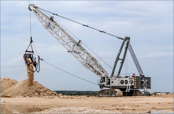
Figure 1: Example of a dragline excavator in action (Source: Liebherr)
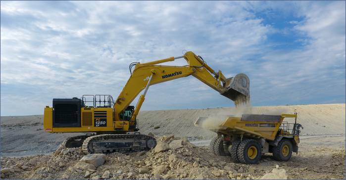
Figure 2: Komatsu large mining excavator loading a mining truck (Source: Komatsu)
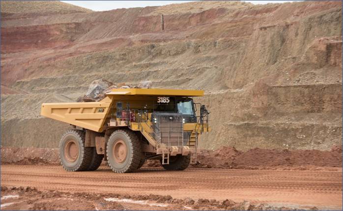 Figure 3: Cat® 777 100-ton mining trucks in action (Source: CAT)
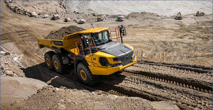
Figure 4: Volvo articulated dump truck (Source: Volvo)
DRY MINING OPERATIONS
The fleet design is underpinned by the successful completion of large-scale dry mining trials during the pilot phase, which confirmed that Kasiya’s soft, friable saprolite-hosted mineralisation can be efficiently extracted using conventional dry mining methods. The trials, conducted on a 120m x 110m test pit excavated to 20m depth, demonstrated that no drilling, blasting, crushing, grinding or milling is required before processing the run-of-mine material.
Based on comprehensive evaluation criteria including safety, technical risk factors, operational flexibility, infrastructure requirements, and capital and operating costs, dragline mining was selected as the optimal method for Kasiya’s planned large-scale operation. The dragline approach offers predominantly single-bench digging operations with extended reach capabilities, resulting in fewer relocation operations and more consistent material blending compared to alternative mining methods.
The dry mining fleet design directly supports the project’s targeting of industry-leading low operating costs and positions Kasiya as a long-life, large-scale operation capable of meeting growing global titanium feedstock and graphite demand.
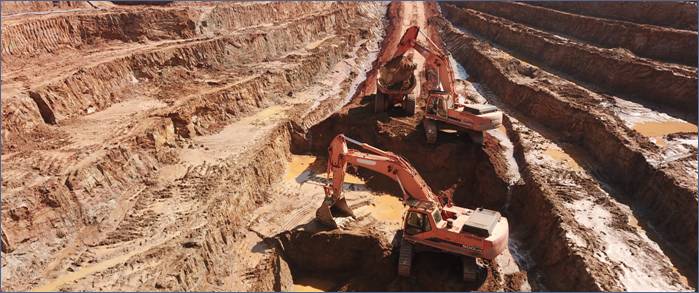
Figure 5: Trial Mining operations at Kasiya during the 2024 pilot phase
DFS PROGRESSION
The completion of mining fleet design represents a critical component of the DFS work program, building on previous milestones including geotechnical investigations, continued product testwork, and signing of a memorandum of understanding regarding power supply, with the Electricity Supply Corporation of Malawi (ESCOM).
The DFS continues to progress including:
· process plant design optimisation,
· infrastructure and logistics planning, and
· environmental and social impact assessments.
|
Enquiries |
|
Frank Eagar, Managing Director & CEO South Africa / Malawi +27 21 140 3190 Sapan Ghai, CCO London +44 207 478 3900 |
|
Nominated Adviser on AIM and Joint Broker |
|
|
SP Angel Corporate Finance LLP |
+44 20 3470 0470 |
|
Ewan Leggat Charlie Bouverat |
|
|
|
|
|
Joint Broker |
|
|
Stifel |
+44 20 7710 7600 |
|
Varun Talwar |
|
|
Ashton Clanfield |
|
|
|
|
|
Buchanan |
+ 44 20 7466 5000 |
#SVML Sovereign Metals Limited – Power Supply MOU & Malawi Hydropower Project
 SOVEREIGN SIGNS POWER SUPPLY MOU AS WORLD BANK APPROVES LANDMARK MALAWI HYDROPOWER PROJECT
· Sovereign and Electricity Supply Corporation of Malawi (ESCOM) enter MOU to secure grid power supply for the Kasiya Rutile-Graphite project
· MOU sets out strategic development workplan to supply 60MW hydropower for steady-state operations through connection to the Nkhoma Substation
· Malawi’s grid power supply to be positively impacted by World Bank’s recent approval of a US$350m grant to support the Mpatamanga Hydropower Storage Project (MHSP) which will significantly increase Malawi’s installed capacity by 2030
· MHSP has been co-developed by the Government of Malawi and the International Finance Corporation (IFC) (part of the World Bank Group) with owners EDF, British International Investment, Norfund and TotalEnergies
Sovereign Metals Limited (ASX:SVM; AIM:SVML; OTCQX:SVMLF) (Sovereign or the Company) is pleased to announce that it has entered into a non-binding Memorandum of Understanding (MOU) with the Electricity Supply Corporation of Malawi (ESCOM) to ensure the long-term supply of electricity to its Kasiya Rutile Graphite Project (Kasiya or the Project) in Malawi. The MOU establishes the framework for negotiating the following future definitive agreements:
· Project Implementation Agreement, including construction and installation of a new 132kV overhead power line, and
· Power Supply Agreement, for the provision of bulk power supply from Malawi’s national grid.
The MOU follows discussions with ESCOM, the operator of Malawi’s national electricity grid, regarding the provision of electricity to the Kasiya Project in preparation for construction and operation. The total installed capacity in Malawi is currently 351MW, with approximately 98% of this capacity coming from hydropower. During Stage 1, Kasiya’s power demand will amount to 30MW, increasing to 60MW at steady-state production in Year 6 of operation. The MOU with ESCOM is a key step in the development of Kasiya and its Definitive Feasibility Study (DFS) due in Q4 2025.
On 15 May 2025, the World Bank approved a US$350m grant to support Malawi’s Mpatamanga Hydropower Storage Project (MHSP), a large infrastructure operation aiming to “transform the country’s energy landscape and its economic development trajectory.” (Source: World Bank)
In September 2022, the Malawian Government selected a consortium of strategic sponsors, which currently owns the MHSP, and consists of Electricité de France (EDF) and SN Malawi BV, which in turn is owned by the UK Government’s development finance institution, British International Investment plc, the Norwegian Parliament’s development finance institution, Norfund, and global energy company TotalEnergies SE. Once complete, the US$1.5Bn MHSP will deliver 358MW of additional generation capacity to the Malawi electricity grid.
Managing Director and CEO Frank Eagar commented: “The signing of the MOU ensures we have a workplan to secure access to a renewable, hydro-based power supply for Kasiya. The future development of the Mpatamanga Hydro Project – expected to commence operations in 2030 – will further enhance the stability and capacity of Malawi’s electricity network. This also reflects ongoing foreign direct investment in Malawi’s infrastructure by the World Bank, IFC, and leading global energy companies such as EDF and TotalEnergies.”
Kasiya Power Supply
Over its planned 25-year life of mine, Kasiya is set to produce an average of 222kt of natural rutile and 233kt of natural flake graphite per annum. At steady-state, Sovereign is positioned to potentially be the world’s largest producer of natural rutile and natural flake graphite with an approximate power demand of 60MW.
To supply power from the hydro-based grid network, a 132kV overhead transmission line will be constructed to connect the Kasiya site to the Nkhoma substation, approximately 97km away. Nkhoma has been identified as the most suitable connection point based on power reliability, technical feasibility, and environmental and social considerations. This line will supply the 132/33kV Kasiya bulk intake substation.

Figure 1: Nkhoma substation has capacity for connection to the Kasiya operation (Source: Millenium Challenge Corporation, USA)
Mpatamanga Hydropower Storage Project
MHSP is one of several large energy projects in Malawi supported by the World Bank Group, reflecting the institution’s strong commitment to supporting this sector as an important enabler of economic growth and development.
In a World Bank press release, Nathan Belete, World Bank Division Director for Malawi, Tanzania, Zambia and Zimbabwe commented: “This new hydropower project is a game-changer for Malawi, capable of catalyzing transformative change in productive economic sectors such as mining, agri-business and tourism. As the country works on driving its economic development agenda, this new source of clean and reliable energy will help drive business growth, create jobs, and improve the lives of millions of Malawians.”
MHSP’s main and regulating dams on the Shire River will generate clean energy and store power to supply electricity during peak demand hours, helping to improve the reliability of Malawi’s national grid. The hydropower facility will also boost the grid’s capacity to support the growing demand of the country’s mining companies, including Sovereign.
Other important investments by the World Bank in Malawi include the Emergency Power Restoration Project focused on rehabilitating the Kapichira power station, the Mozambique-Malawi Regional Interconnector Project, and the recently approved Accelerating Sustainable and Clean Energy Access Transformation (ASCENT) in Malawi project aiming to improve last-mile electricity connections for the Malawian population.

Figure 2: MHSP hydro infrastructure (Source: World Bank)
ESCOM MOU
The purpose of the MOU with ESCOM is to record the mutual understanding for negotiation in good faith of a Project Implementation Agreement and a Power Supply Agreement (Definitive Agreements). The MOU is non-exclusive and non-binding and remains subject to negotiation and execution of the Definitive Agreements. The MOU will expire on execution of the Definitive Agreements or on 30 June 2026, whichever is the earliest, but it can be mutually extended by 12 months.
|
Enquiries |
|
Frank Eagar, Managing Director & CEO South Africa / Malawi +27 21 140 3190
Sapan Ghai, CCO London +44 207 478 3900 |
|
Nominated Adviser on AIM and Joint Broker |
|
|
SP Angel Corporate Finance LLP |
+44 20 3470 0470 |
|
Ewan Leggat Charlie Bouverat |
|
|
|
|
|
Joint Broker |
|
|
Stifel |
+44 20 7710 7600 |
|
Varun Talwar |
|
|
Ashton Clanfield |
|
|
Buchanan |
+ 44 20 7466 5000 |
Competent Person Statement
The information in this announcement that relates to Production Targets, Ore Reserves, Processing, Infrastructure and Capital and Operating Costs is extracted from an announcement dated 22 January 2025, which is available to view at www.sovereignmetals.com.au. Sovereign confirms that: a) it is not aware of any new information or data that materially affects the information included in the original announcement; b) all material assumptions and technical parameters underpinning the Production Target, and related forecast financial information derived from the Production Target included in the original announcement continue to apply and have not materially changed; and c) the form and context in which the relevant Competent Persons’ findings are presented in this presentation have not been materially modified from the original announcement.
The information in this announcement that relates to the Exploration Results (metallurgy – rutile and graphite) is extracted from announcements dated 8 May 2024, 15 May 2024, 4 September 2024 and 21 November 2024, which are available to view at www.sovereignmetals.com.au. Sovereign confirms that a) it is not aware of any new information or data that materially affects the information included in the original announcement; b) all material assumptions included in the original announcement continue to apply and have not materially changed; and c) the form and context in which the relevant Competent Persons’ findings are presented in this report have not been materially changed from the announcement.
The information in this announcement that relates to the Mineral Resource Estimate is extracted from Sovereign’s 2024 Annual Report and is based on, and fairly represents information compiled by Mr Richard Stockwell, a Competent Person, who is a fellow of the Australian Institute of Geoscientists (AIG). Mr Stockwell is a principal of Placer Consulting Pty Ltd, an independent consulting company. Sovereign confirms that a) it is not aware of any new information or data that materially affects the information included in the original announcement; b) all material assumptions included in the 2024 Annual Report continue to apply and have not materially changed; and c) the form and context in which the relevant Competent Persons’ findings are presented in 2024 Annual Report have not been materially changed from the disclosure in the 2024 Annual Report.
|
Ore Reserve for the Kasiya Deposit |
|
||||||
|
Classification |
Tonnes |
Rutile Grade |
Contained Rutile |
Graphite Grade (TGC) (%) |
Contained Graphite |
RutEq. Grade* |
|
|
Proved |
– |
– |
– |
– |
– |
– |
|
|
Probable |
538 |
1.03% |
5.5 |
1.66% |
8.9 |
2.00% |
|
|
Total |
538 |
1.03% |
5.5 |
1.66% |
8.9 |
2.00% |
|
* RutEq. Formula: Rutile Grade x Recovery (100%) x Rutile Price (US$1,484/t) + Graphite Grade x Recovery (67.5%) x Graphite Price (US$1,290/t) / Rutile Price (US$1,484/t). All assumptions are from the Kasiya PFS ** Any minor summation inconsistencies are due to rounding
|
Kasiya Total Indicated + Inferred Mineral Resource Estimate at 0.7% rutile cut-off grade (inclusive of Ore Reserves) |
|||||
|
Classification |
Resource |
Rutile Grade |
Contained Rutile |
Graphite Grade (TGC) (%) |
Contained Graphite |
|
Indicated |
1,200 |
1.0% |
12.2 |
1.5% |
18.0 |
|
Inferred |
609 |
0.9% |
5.7 |
1.1% |
6.5 |
|
Total |
1,809 |
1.0% |
17.9 |
1.4% |
24.4 |
Forward Looking Statement
This release may include forward-looking statements, which may be identified by words such as “expects”, “anticipates”, “believes”, “projects”, “plans”, and similar expressions. These forward-looking statements are based on Sovereign’s expectations and beliefs concerning future events. Forward looking statements are necessarily subject to risks, uncertainties and other factors, many of which are outside the control of Sovereign, which could cause actual results to differ materially from such statements. There can be no assurance that forward-looking statements will prove to be correct. Sovereign makes no undertaking to subsequently update or revise the forward-looking statements made in this release, to reflect the circumstances or events after the date of that release.
#BRES Blencowe Resources PLC – Appointment of Leading Engineering Firm to DFS
 Highlights
· Blencowe continues to progress the Orom-Cross project with appointment of a notable engineering firm to manage the Definitive Feasibility Study (“DFS”).
· Appointment of CPC Engineering (“CPC”) of Perth to lead and develop the DFS for Orom-Cross.
· CPC have extensive experience in African graphite projects and Blencowe will leverage this knowledge to refine the delivery of the Orom-Cross DFS.
Blencowe Resources Plc (“Blencowe Resources” or the “Company”) (LSE: BRES) is pleased to announce it has engaged leading engineering firm CPC Engineering to lead, deliver and sign off on the DFS for the Orom-Cross Graphite Project.
CPC has extensive experience in other leading graphite projects in East Africa, having completed the DFS for the Maniry Graphite Project (Black Earth Minerals, ASX: BEM) in Madagascar, as well as both the Mahenge (Black Rock Mining Ltd, ASX: BKT) and Chilalo Graphite (Evolution Energy Minerals, ASX: EV1) Projects in Tanzania and the scoping study for the Ancuabe Graphite Project (Triton Minerals, ASX: TON) in Mozambique. CPC also completed the detailed engineering, procurement, construction support and commissioning services for the Syrah Resources (ASX: SYR) Balama Graphite Project in Mozambique.
Blencowe is pleased to have partnered with a firm with extensive experience in both graphite and flotation circuits. CPC will work with the Company and various other Ugandan service providers in the delivery of the DFS for Orom-Cross Graphite in 2023.
The CPC works will include:
· Optimisation of the process plant design, incorporating results of the various testwork programs from SGS, IMO and the pilot plant works (Jilin/China) along with CPC’s expertise in design and construction of graphite process plants.
· Provide updated and optimised CAPEX and OPEX for project cost and schedule certainty;
· Provide updated project costs and schedule for the Project non-processing Infrastructure.
· Sign off on full DFS once completed to provide the third party approval from a recognised leading technical firm as required to ensure project funding support.
Cameron Pearce, Executive Chairman commented;
“We are pleased to add another high-quality partner to the Orom-Cross Project. CPC has a very impressive track record within the graphite market and we are now able to leverage off their skills, experience and relationships to ensure we deliver a first class DFS.“
He continued “The graphite market continues to shift in our favour and we expect the supply-demand imbalance to widen further, as demand for graphite accelerates, given its material role within lithium-ion batteries. Orom-Cross has continued to exceed our expectations and we remain focused on delivering a world class project. CPC are recognised as one of the top tier engineering firms within the graphite sector and their sign off on the DFS will not only help optimise the Project, but also provide the credibility required for project funding and market support.”
For further information please contact:
|
Blencowe Resources Plc Sam Quinn |
www.blencoweresourcesplc.com Tel: +44 (0)1624 681 250
|
|
Investor Relations Sasha Sethi |
Tel: +44 (0) 7891 677 441
|
|
Tavira Financial Jonathan Evans |
Tel: +44 (0)20 3192 1733
|
|
First Equity Limited Jason Robertson |
Tel: +44(0)20 7330 1833 jasonrobertson@firstequitylimited.com
|
Twitter https://twitter.com/BlencoweRes
LinkedIn https://www.linkedin.com/company/72382491/admin/
About CPC Engineering
CPC Engineering is a privately owned, Perth-based engineering company with 50 years’ experience providing reliable and practical engineering solutions to the resources industry, both nationally and internationally. CPC employs over 350 personnel and specialises in engineering design, construction and maintenance.
CPC Project Design is located at CPC Engineering head office in West Perth and is a multidiscipline engineering design, procurement, construction and project management team which has developed a reputation for delivering practical and cost-effective services to the resource industry.
CPC has extensive resource engineering experience with clients that include Syrah Resources, BlackEarth Minerals, Black Rock Mining, Albemarle, First Quantum, AngloGold Ashanti, Tronox Limited OceanaGold, Newmont, Barrick Gold and Sandfire Resources.
Background
Orom-Cross Graphite Project
Orom-Cross is a potential world class graphite project both by size and end-product quality, with a high component of more valuable larger coarse flakes within the deposit.
A 21-year Mining Licence for the Project was issued by the Ugandan Government in 2019 following extensive historical work on the deposit and Blencowe completed a successful Pre-Feasibility Study in 2022. The Company has now moved into the Definitive Feasibility Study phase as it drives towards first production.
Orom-Cross presents as a large, shallow open-pitable deposit, with a maiden JORC Indicated & Inferred Mineral Resource deposit of 24.5Mt @ 6.0% Total Graphite Content, with only a small percentage of the overall deposit drilled to date. Development of the resource is expected to benefit from a low strip ratio and free dig operations, thereby ensuring lower operating and capital costs.
#ECHO Echo Energy – Operational Update
Echo Energy, the Latin American focused energy company, is pleased to provide an operational update regarding its Santa Cruz Sur assets, onshore Argentina for Q4 2021 to 30 November 2021.
Daily operations across the asset base in Santa Cruz Sur and the delivery of produced gas to industrial customers under contract have continued uninterrupted during the first two months of Q4 2021. Production over the period from 1 January 2021 to 30 November 2021 reached an aggregate of 523,735 boe net to Echo, including 74,605 bbls of oil and condensate and 2,695 mmscf of gas.
As a result of the completion of capacity increasing infrastructure works, gas production in November 2021 averaged 7.1 MMscf/d net to Echo, an increase over the 6.7 MMscf/d net production rate during the previous month.
Net liquids production in the first two months of Q4 2021 averaged 255 bopd, and is an increase of 31% over Q1 2021 levels prior to the commencement of production optimisation and the bringing of shut in wells back on line. The benefit of both infrastructure maintenance and the previously announced commercial focus on high-quality blends at Santa Cruz Sur has also led to an increased frequency of oil sales during Q4 2021 to date, with total liquids sales net to Echo in quarter four to date of 16,855 bbls (Q3 2021 total of: 15,050 bbls). This increase in liquids production has helped to offset the expected natural decline in gas production over the year.
The Company looks forward to updating shareholders on production levels on a quarterly basis going forward.
For further information, please contact:
|
Echo Energy Martin Hull, Chief Executive Officer
|
via Vigo Communications |
|
Vigo Consulting (IR & PR Advisor) Patrick d’Ancona Chris McMahon
|
+44 (0) 20 7390 0230 |
|
Cenkos Securities (Nominated Adviser) Ben Jeynes Katy Birkin
|
+44 (0) 20 7397 8900 |
|
Shore Capital (Corporate Broker)
|
+44 (0) 20 7408 4090 |
Kavango Resources #KAV – Operations Update

Kavango Resources plc (LSE:KAV), the exploration company targeting the discovery of world-class mineral deposits in Botswana, is pleased to provide an operational update.
Highlights
Ø Recruitment of new senior commercial and exploration personnel
– Tiyapo (Tipps) Ngwisanyi is the former and founding CEO of the Government owned Botswana Geoscience Institute. Tipps has joined the Company as Managing Director of Kavango Minerals (Pty) Ltd
– John Lauderdale is a Chartered Geologist and seasoned exploration professional, who has run large-scale exploration programmes across Africa. John has joined Kavango as Senior Consulting Geologist
– Jeremy S. Brett is an internationally recognised Professional Geoscientist who has worked previously in the Kalahari Suture Zone (“KSZ”). Jeremy is now working with Kavango as a Senior Consulting Geophysicist.
Ø Updated geophysical model of Target Area B
– Target Area B covers the “Great Red Spot” magnetic anomaly, which has been subject to previous exploration
– Historic exploration of the Great Red Spot was limited by the technology available at the time
– The Company now believes the primary source of the Great Red Spot’s magnetic anomaly is towards its northern edge
– This appears to be coincidental with Target B1 (announced 2 July 2021). Planned drilling to test this assessment.
– Target B1 is a 475m by 550m conductive anomaly, with a conductance reading of 8,200 Siemens and a decay constant estimated to be in excess of 350ms.
– Jeremy Brett and Kavango CEO Ben Turney have given a short video presentation about the updated geophysical model of Target Area B, which is available through the following link – https://youtu.be/0yQx_vLD8_Y
Ø Drilling update
– Downhole gyroscopic survey complete. TA2DD002 successfully drilled to within 1 degree of original target
– Drilling recommenced at TA2DD002, with target depth of 1,000m expected overnight on Wednesday 22 September
– On completion of operations in Target Area A, the rig will be mobilised to Target Area B
– Kavango will then drill one geological hole into the Great Red Spot and one borehole to intersect the conductor of Target B1
Ben Turney, Chief Executive Officer of Kavango Resources, commented:
“Our vision is to build a world-class minerals exploration firm in Botswana. These senior appointments are a significant step on our way to achieving this vision .
I am delighted to welcome Tipps, John and Jeremy on board. Each brings valuable skills, expertise and experience to Kavango. These senior appointments are the culmination of months of hard work and reflect the significant progress we have made as a business over the course of 2021.
We still have a lot to do to make our first discovery, but it feels like the pieces are falling into place.”
Recruitment of senior team members
Over recent months, Kavango has made the following appointments:
– Tiyapo (Tipps) Ngwisanyi (Managing Director, Kavango Minerals (Pty) Ltd))
Tipps is a geoscientist, who began his career at the Botswana Department of Geological Survey. In 2010 Tipps became Director of the Geological Survey and was then appointed as founding CEO of the Botswana Geoscience Institute in 2015, a position he held until he joined Kavango at the start of August.
As Managing Director of Kavango Minerals (Pty) Ltd, the Company’s local operating subsidiary in Botswana, Tipps is responsible for in-country commercial management and liaisons with all stakeholders, from the Department of Mines to local farmers and community representatives.
– John Lauderdale (Group Consulting Geologist)
John is a Chartered Geologist and seasoned exploration professional, who has been responsible for annual budgets of up to $80million and run teams of <350 personnel. During his career John has successfully worked on projects throughout Africa, from Morocco to South Africa.
Over the last three months John has been helping Kavango implement a comprehensive overhaul of the Company’s in-country operations. John works full time for Kavango and reports directly to the board of directors.
– Jeremy S. Brett (Senior Consulting Geophysicist)
Jeremy is an experienced geoscientist, with a strong geophysical, geological and project management background. Over the last 27 years Jeremy has designed, supervised, quality assured and interpreted geophysical and geological exploration programmes across many base and precious metal projects around the world.
Jeremy has specific relevant experience in exploring for Nickel-Copper-PGEs mafic/ultramafic complexes, having previously worked on the Kalahari Suture Zone for Canadian firms in the late 1990s and early 2000s. Jeremy was responsible for the siting of Hole GRS1, which targeted the centre of the “Great Red Spot” and was drilled to a depth of 934m in 2002.
Jeremy published a paper on the KSZ in the Journal of African Earth Sciences in 2002, titled “Geophysical exploration of the Kalahari Suture Zone”. He has been assisting Kavango since March this year and is now conducting a review of the Company’s geophysical strategy.
Geophysical update on Target Area B
Once current drilling operations are complete at Target Area A in the KSZ, Mindea Exploration and Drilling Services (Pty) (“Mindea”) will immediately mobilise the rig to Target Area B to commence drilling there.
Target Area B is in a distinct geological setting to Target Area A. It covers an area that is known as the “Great Red Spot”, thanks to its physical appearance on magnetic maps. The Great Red Spot is a previously identified large-scale magnetic anomaly that has been subject to limited historic exploration.
In 2002 a Canadian junior exploration company, Opawica Exploration Inc (“Opawica”), drilled Hole GRS-1 into the centre of the Great Red Spot. GRS-1 was drilled to a depth of 934m, encountering 17m of gabbroic rocks from 917m. However, the Company believes that limitations in available geophysical technology meant that accurate profiling of the Great Red Spot was not possible at that time.
Thanks to significant advances in geophysical technology and analytical software over the last two decades, Kavango believes it has now been able to create a more accurate geophysical model of the Great Red Spot (the “New GRS Model”). The New GRS Model combines historic data with data gathered by the Company in its exploration of the KSZ.
The New GRS Model estimates that the primary source of the magnetic anomaly of the Great Red Spot is positioned much closer to its northern boundary than previously recognised. Kavango believes this magnetic anomaly could be associated with a combination of Karoo and/or Proterozoic intrusions.
According to Kavango’s analysis, Target B1 appears to be coincidental with the edge of the magnetic anomaly. The Company will seek to confirm this interpretation through drilling.
Kavango’s Consulting Geophysicist Jeremy Brett and CEO Ben Turney have given a video interview to Alan Green, CEO of Brand Communications, to provide greater context about the Company’s modelling of Target Area B.
The link to this presentation can be viewed here:
Drilling update Hole TA2DD02
Drilling at Hole TA2DD002 was temporarily halted on Tuesday 21 September at 950m to allow for the downhole gyroscopic survey. A gyroscopic survey is used to measure the angle of a borehole. This survey was successfully completed and confirms Hole TA2DD002 has been drilled to within 1 degree of the original objective. Given challenging drilling conditions closer to surface and the depth Hole TA2DD002 has been drilled to, the Company regards this as a notable technical success by Mindea and Equity Drilling Ltd.
Drilling has subsequently resumed and is expected to reach the final target depth of 1,000m overnight on Wednesday 22 September.
Kavango has used a TLB Loader to prepare a 20km roadway from Target Area A to Target Area B, so that the drill rig and accompanying equipment can be transported quickly and safely.
Kavango has also prepared drills pads and now plans to drill two boreholes:
– First, the Company plans to drill a geological hole to a depth of up to 1,000m, targeting what it believes to be the shallowest point of the magnetic high of the Great Red Spot. Kavango expects to encounter Karoo and Proterozoic gabbros in this hole.
– Second, the Company plans to drill a hole to intersect Target B1 to an estimated depth of up to 600m. Target B1 is a 475m by 550m conductive anomaly, with a conductance reading of 8,200 Siemens and a decay constant estimated to be in excess of 350ms. Kavango’s geophysical model estimates that Target B1 is positioned at the northern edge of the Great Red Spot.
The primary objective of both boreholes is to extract core samples for full sweep rock analysis.
————————————————————————————————————-
Further information in respect of the Company and its business interests is provided on the Company’s website at www.kavangoresources.com and on Twitter at #KAV.
For additional information please contact:
Kavango Resources plc
Ben Turney
+46 7697 406 06
First Equity (Joint Broker)
+44 207 374 2212
Jason Robertson
SI Capital Limited (Joint Broker)
+44 1483 413500
Nick Emerson
Kavango Competent Person Statement
The information in this press release that relates to “geological and/or geophysical results” for the KSZ Project is based on information compiled or reviewed by Mr Mike Moles BSc (Geology) & BSocSci (African Studies), a competent person who is a Member of the Australian Institute of Mining & Metallurgy. Mr Moles has sufficient experience that is relevant to the style of mineralisation and type of deposits under consideration and to the activity, which he is undertaking to qualify as a Competent Person as defined in the 2012 Edition of the ‘Australasian Code for Reporting of Exploration Results, Mineral Resources and Ore Reserves’. Mr Moles consents to the inclusion in this release of the exploration results for the Project in the form and context in which it appears. Mr Moles is a beneficial shareholder of Kavango Resources plc.