
Home » Posts tagged 'mineral'
Tag Archives: mineral
#KDNC Cadence Minerals PLC – Investor Presentation via Investor Meet Company
 CADENCE MINERALS PLC (AIM: KDNC) is pleased to announce that Chief Executive Officer, Kiran Morzaria will provide a live presentation via Investor Meet Company on 04 Sept 2026 at 10:00 BST.
The presentation is open to all existing and potential shareholders. Questions can be submitted pre-event via your Investor Meet Company dashboard up until 03 Sept 2026, 09:00 BST, or at any time during the live presentation.
Investors can sign up to Investor Meet Company for free and add to meet CADENCE MINERALS PLC via:
https://www.investormeetcompany.com/cadence-minerals-plc/register-investor
Investors who already follow CADENCE MINERALS PLC on the Investor Meet Company platform will automatically be invited.
|
For further information, contact:
|
|
|
Cadence Minerals plc |
+44 (0) 20 3582 6636 |
|
Andrew Suckling |
|
|
Kiran Morzaria |
|
|
|
|
|
Zeus (NOMAD & Broker) |
+44 (0) 20 3829 5000 |
|
James Joyce |
|
|
Darshan Patel |
|
|
|
|
|
Fortified Securities – Joint Broker |
+44 (0) 20 3411 7773 |
|
Guy Wheatley |
|
|
|
|
|
Brand Communications |
+44 (0) 7976 431608 |
|
Public & Investor Relations |
|
|
Alan Green |
#AYM Anglesey Mining PLC – James McFarlane Confirmed as Principal Geologist
 Anglesey Mining plc (AIM: AYM), the UK-based mineral exploration and development company and the 100% owner of the Parys Mountain Cu-Zn-Pb-Ag-Au VMS project (“Parys Mt.”) in Anglesey, North Wales, is pleased to confirm the appointment of James McFarlane as Principal Geologist on a retained basis, as outlined in a recent regulatory announcement .
James is a Chartered Geologist and Chartered Engineer with more than 20 years’ of international experience spanning mineral exploration, resource evaluation, mine development and mining operations. Throughout his career, he has led geological programmes, resource studies, technical due diligence and project development across a range of base and precious metal projects, with specific knowledge in volcanogenic massive sulphide deposits and UK mine development. His background combines technical excellence with practical operational and project delivery experience.
Working as part of the Company’s executive management team, James will provide strategic geological and geometallurgical leadership to support the advancement of the Parys Mountain project. His responsibilities will include progressing geological interpretation, guiding future Mineral Resource updates and exploration strategy, supporting the ongoing economic reassessment of the project and mentoring the Company’s recently appointed Exploration Geologist.
Further information on James’ professional background can be found via his LinkedIn profile .
Andrew Fulton, Chief Executive Officer of Anglesey Mining , commented:
“We are delighted to welcome James to Anglesey Mining. Parys Mountain is the product of decades of geological work and technical commitment. Our objective is to build on those strong foundations by applying today’s technical expertise and disciplined project development to unlock the considerable future value of the asset. James’ experience across exploration, resource development and mining operations, together with his understanding of UK projects, makes him an excellent addition to our technical team as we continue to advance Parys Mountain”
James McFarlane, Principal Geologist of Anglesey Mining , commented:
“Parys Mountain is one of the UK’s most exciting polymetallic development projects, with considerable exploration upside alongside an established Mineral Resource. I look forward to working with the team to enhance the geological understanding of the project and support its progression towards development.”
For further information, please visit the Company’s website: www.angleseymining.co.uk
-Ends-
For further information, please contact:
Anglesey Mining plc (via Yellow Jersey PR Limited)
Jim Williams, Executive Chairman
Andrew Fulton, CEO
angleseymining@yellowjerseypr.com
Davy
Nominated Adviser & Joint Corporate Broker
Brian Garrahy/Daragh O’Reilly
Tel: +353 1 679 6363
AlbR Capital Limited
Joint Corporate Broker
Lucy Williams/Duncan Vasey
Tel: +44 (0)20 7562 0930
Yellow Jersey PR Limited
Financial & Media Relations
Dominic Barretto/Shivantha Thambirajah
Tel: +44 (0)20 3004 9512
About Anglesey Mining plc:
Anglesey is advancing the UK’s largest polymetallic VMS project at the 100% owned Parys Mountain Cu-Zn-Pb-Ag-Au VMS deposit in North Wales.
#FDR First Development Resources PLC – Successful Northern Territory Government Grant
 First Development Resources plc (AIM: FDR), the UK-based, Australia-focused mineral exploration company, is pleased to announce that its wholly owned subsidiary, URE Metals Pty Ltd, has been selected as a successful recipient under Round 19 of the Northern Territory Government’s Geophysics and Drilling Collaborations (“GDC”) Programme.
The Company has been awarded AU$100,000 (inclusive of GST) to support the Phase I Reverse Circulation (“RC”) drilling programme at the Lander West Gold Target, part of the Company’s flagship Selta Project in the Northern Territory, Australia.
HIGHLIGHTS
· AU$100,000 grant awarded under Round 19 of the Northern Territory Government’s Geophysics and Drilling Collaborations Programme.
· Non-dilutive funding to support the Company’s maiden Phase I RC drilling programme at the Lander West Gold Target.
· Phase I programme fully funded, with drilling scheduled to commence in July 2026.
· Grant award provides independent validation of the technical quality and prospectivity of the Lander West gold target.
· Upcoming drilling represents the first meaningful test of the broader gold system at depth with much of the prospective geology remaining effectively untested below 50 metres.
Successful applicants under Round 19 of the Northern Territory Government’s Geophysics and Drilling Collaborations Programme were announced by the Minister for Mining and Energy, the Hon. Gerard Maley MLA, on 9 June 2026. Following the Minister’s announcement, the Company is pleased to provide shareholders with details of the grant award and its intended application to the Company’s maiden drilling programme at the Lander West Gold Target.
The Geophysics and Drilling Collaborations Programme is funded through the Northern Territory Government’s Resourcing the Territory initiative and administered by the Northern Territory Geological Survey. The programme supports mineral exploration and new discoveries across the Northern Territory.
The grant funding will contribute towards the Company’s maiden Phase I RC drilling programme at the Lander West Gold Target, which forms part of the Selta Project located within the highly prospective Aileron Province of the Northern Territory.
Importantly, the award represents both non-dilutive funding and independent recognition of the technical merit of the Company’s exploration strategy at Lander West.
Tristan Pottas, Chief Executive Officer of FDR, commented:
“We are delighted to have been selected as a successful recipient under the Northern Territory Government’s Round 19 Geophysics and Drilling Collaborations Programme. The award provides independent validation of the technical work completed to date and highlights the prospectivity of the Lander West Gold Target.
Over the past seven months, the Company has adopted a systematic and methodical approach to advancing Lander West from an initial concept to a drill-ready opportunity. The support provided by the Northern Territory Government and the Northern Territory Geological Survey represents an important endorsement of both the quality of our technical work and the potential of the project.
With all regulatory approvals secured and preparations progressing well, we look forward to commencing our maiden drilling programme in July. This programme will provide the first meaningful test of the Lander West Gold Target at depth and marks an important milestone in the development of what we believe could become a significant gold discovery for the Company and its shareholders.
On behalf of the Board, I would like to thank the Northern Territory Government and the Northern Territory Geological Survey for their continued support of mineral exploration and for fostering one of Australia’s premier jurisdictions for exploration investment.”
PHASE I RC DRILLING PROGRAMME
The Phase I RC drilling programme (Figure 1) represents the first meaningful test of the Lander West Gold Target at depth and has been designed to evaluate several high-priority gold targets associated with the Stafford Gold Trend, a recognised mineralised corridor located immediately south of the project area.
Target generation has been guided by the integration of historical geological and geochemical datasets together with several phases of modern geophysical surveying completed by the Company since late 2025. These datasets have identified multiple gold targets concealed beneath shallow cover.
Previous drilling within the target area was largely focused on commodities other than gold and was generally shallow in nature. Consequently, much of the prospective geology remains effectively untested below 50 metres, meaning the upcoming programme will provide the first meaningful assessment of the broader gold system at depth.
The initial programme is expected to comprise approximately 2,000 metres of RC drilling, with flexibility to expand the programme to approximately 3,000 metres subject to results.
The programme is fully funded and all regulatory approvals required to commence drilling have now been secured. Preparations are progressing ahead of the planned mobilisation of the drilling contractor in July 2026.
The Company looks forward to providing shareholders with further updates as drilling preparations advance and activities commence at the Lander West Gold Target.
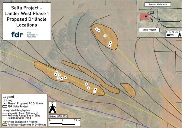
Figure 1: Phase 1 Proposed Drillhole Locations on the Lander West Target.
For further information visit www.firstdevelopmentresources.com or contact the following:
|
First Development Resources plc Tristan Pottas (CEO) |
Tel: +44 (0) 20 3778 1397 |
|
Beaumont Cornish Limited Nominated Adviser Roland Cornish / Asia Szusciak |
Tel: +44 (0) 20 7628 3396 |
|
SI Capital Limited Broker Nick Emerson
|
Tel: +44 (0) 1483 413 500 |
Beaumont Cornish Limited (“Beaumont Cornish”) is the Company’s Nominated Adviser and is authorised and regulated by the FCA. Beaumont Cornish’s responsibilities as the Company’s Nominated Adviser, including a responsibility to advise and guide the Company on its responsibilities under the AIM Rules for Companies and AIM Rules for Nominated Advisers, are owed solely to the London Stock Exchange. Beaumont Cornish is not acting for and will not be responsible to any other persons for providing protections afforded to customers of Beaumont Cornish nor for advising them in relation to the proposed arrangements described in this announcement or any matter referred to in it.
ABOUT FIRST DEVELOPMENT RESOURCES
First Development Resources’ assets comprise eight granted tenements covering a total area of 2,314.4km2. Five of the tenements, comprising three prospective copper-gold projects, are located in Western Australia (WA) while the remaining three tenements, comprising a rare-earth element (REE), uranium, lithium and gold project, are located in the Australian’s Northern Territory. All tenements are wholly owned by FDR. The assets are a mixture of drill ready and earlier stage exploration.
The WA Projects include the Company’s Wallal Project as well as Ripon Hills and Braeside West Projects situated in the Paterson Province, which is widely regarded as one of the most productive regions in Australia for the discovery of world-class gold-copper deposits, and which is home to several world-class mines and more recent discoveries.
The Selta Project in the Northern Territory is located in an area considered highly prospective for uranium and rare-earth element mineralisation along with base and precious metal mineralisation. Numerous companies are actively exploring within the region.
Beyond the existing portfolio, FDR is actively looking to expand its portfolio through the acquisition of early-stage exploration projects in Australia.
#AYM Anglesey Mining PLC – Change of Non-Executive Directors
 Anglesey Mining plc (AIM: AYM), the UK-based mineral exploration and development company and the 100% owner of the Parys Mountain Cu-Zn-Pb-Ag-Au VMS project in Anglesey, North Wales, is pleased to announce the appointment of Messrs. Martin Wood and Taj Singh to the Board as Independent Non-Executive Directors, effective immediately. Martin and Taj will replace Andrew King and Doug Hall, who are stepping down from the Board with immediate effect.
Martin, who is the founder and Managing Director of Vicarage Capital, an FCA-registered brokerage house which aids junior and mid-cap resource companies, was the CEO of ASX-listed Kogi Iron Limited between 2017 and 2019 and, since 2022, has been the Senior Independent Non-Executive Director and Remuneration Committee Chair at AIM-listed Tungsten West Limited.
Before Vicarage Capital, Martin worked in corporate finance at NM Rothschild & Sons, Standard Bank and Benfield Advisory, providing services to resource companies. Martin was a director of Royal Helium Limited, which went into a Voluntary Company Arrangement with its bondholders in 2023.
Martin holds an MBA from Exeter University.
Martin currently holds no direct interests in the Company’s ordinary shares.
Martin Wood, aged 57, holds or has held the following directorships/partnerships in the past five years:
| Current Directorships/Partnerships | Former Directorships/Partnerships (past five years) |
| Vicarage Capital Limited | Altona Energy Plc |
| Tungsten West Plc | Toya Gold SL |
| Royal Helium Limited |
Taj is an accomplished mining executive with more than 25 years of experience in the minerals sector and has raised over $400 million in equity throughout his career. He is currently the President and CEO of Crown 80 Consulting Services Ltd., which provides technical and capital markets advisory services within the minerals and mining industry.
Taj was the founder, President and CEO of TSX/V-listed First Nordic Metals Corp., which merged with Mawson Gold Ltd. in late 2025 to form TSX/V-listed Gold Sky Resources. Gold Sky Resources, a gold explorer and developer focused on Northern Europe, is currently valued at $720 million. At First Nordic Metals Corp., he executed numerous acquisitions, oversaw more than $100 million in equity financing, and helped increase the market capitalisation 30x during his tenure.
His previous experience includes serving as the founding President and CEO of TSX/V-listed NOA Lithium Brines, where he had significant success with the flagship project in Argentina, the founding President and CEO of TSX/V-listed Discovery Silver Corp., where he spearheaded the company to grow to a market capitalisation of more than $750 million, and he was the Chairman of TSX/V listed Silver Viper Minerals Corp from February 2024 to December 2025.
Taj is a Professional Engineer (P.Eng), a Chartered Professional Accountant (CPA), a Certified Management Accountant (CMA) and holds B.Eng and M.Eng qualifications in Minerals Processing and Metallurgy.
Taj currently holds no direct interests in the Company’s ordinary shares.
Taj Singh, aged 46, holds or has held the following directorships/partnerships in the past five years:
| Current Directorships/Partnerships | Former Directorships/Partnerships (past five years) |
| Silver Viper Minerals Corp | |
| First Nordic Metals Corp | |
| NOA Lithium Brines Inc | |
| Discovery Silver Corp |
Jim Williams, Executive Chairman of Anglesey, commented:
“I would like to take this opportunity to thank both Andrew and Doug for their service to Anglesey and wish them the very best for the future.”
“On behalf of Anglesey, I am delighted to welcome both Martin and Taj as our new independent Non-Executive Directors, which now fully complements our Board restructuring. Martin and Taj bring their demonstrable expertise in the mining sector to the Company at its critical point of strategic rejuvenation for the future.”
For further information, please visit the Company’s website: www.angleseymining.co.uk
-Ends-
For further information, please contact:
Anglesey Mining plc (via Yellow Jersey PR Limited)
Jim Williams, Executive Chairman
angleseymining@yellowjerseypr.com
Davy
Nominated Adviser & Joint Corporate Broker
Brian Garrahy/Daragh O’Reilly
Tel: +353 1 679 6363
AlbR Capital Limited
Joint Corporate Broker
Lucy Williams/Duncan Vasey
Tel: +44 (0)20 7562 0930
Yellow Jersey PR Limited
Financial & Media Relations
Dominic Barretto/Shivantha Thambirajah
Tel: +44 (0)20 3004 9512
About Anglesey Mining plc:
Anglesey is advancing the UK’s largest copper project at the 100% owned Parys Mountain Cu-Zn-Pb-Ag-Au VMS deposit in North Wales.
#BRES Blencowe Resources PLC – Beehive Deposit Maiden JORC Resource
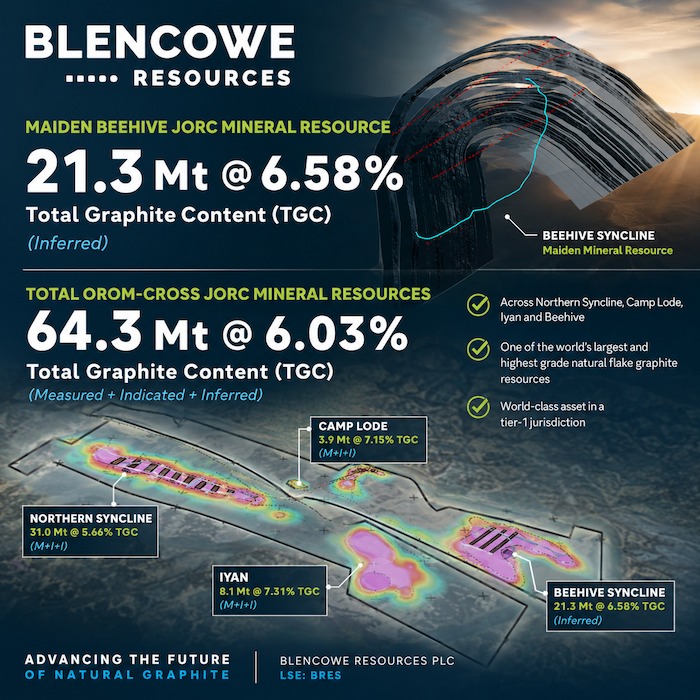 Blencowe Resources Plc (LSE: BRES) is pleased to announce a maiden JORC (2012) Mineral Resource Estimate for the Beehive deposit, part of the Company’s 100% owned Orom-Cross graphite project in Uganda.
Beehive is one of two substantial new discoveries (together with Iyan) made through the Company’s most recent drilling programme and represents another major step change in Orom-Cross scale. Following the maiden Iyan JORC Mineral Resource (which lifted the Orom-Cross resource base by 66% to 43.0 Mt), the maiden Beehive JORC Mineral Resource adds 21.3 Mt @ 6.58% TGC (Inferred) and increases total Orom-Cross JORC Mineral Resources to 64.3 Mt @ 6.03% TGC (Measured + Indicated + Inferred) across Northern Syncline, Camp Lode, Iyan and Beehive.
This further demonstrates Orom-Cross as a multi-deposit, long-life, large-scale graphite development with total Orom-Cross JORC Mineral Resources up 168% since commencement of the Stage 7 programme.
Importantly, the current Beehive JORC Resource has been modelled over only circa 22% of the Beehive anomaly and largely within the upper 25-30 metres tested by shallow drilling. Combined with previously reported deep drilling demonstrating mineralisation continuing to approximately 100 metres depth, the Company believes Beehive retains significant upside potential beyond the current modelled area.
With a materially expanded resource base now defined, the Company has been progressing further DFS optimisation work to incorporate the enlarged inventory, evolving downstream pathways, and ongoing commercial discussions. This work is well advanced and a further update is expected prior to the end of Q2 2026.
Highlights:
Beehive Maiden JORC Mineral Resource update;
· Beehive JORC Mineral Resource: 21.3 Mt @ 6.58% TGC (Inferred) at a 3.5% TGC cut-off
· Higher-grade component defined: 17.5Mt @ 7.0% TGC
· Total Orom-Cross JORC Mineral Resources (revised): 64.3Mt @ 6.03% TGC (Measured + Indicated + Inferred) at a 3.5%TGC cut-off
o Measured Resource: 1.20 Mt @ 5.13% TGC
o Indicated Resource: 16.41 Mt @ 5.7% TGC
o Inferred Resource: 46.70 Mt @ 6.17% TGC
· Stage 7 drill programme impact: total Orom-Cross JORC Mineral Resources have increased by 168% since commencement of the Stage 7 programme
· Depth continuity: deep drilling previously demonstrated mineralisation continuing to >100m at both Iyan and Beehive deposits
· Beehive scale: the current model covers just 22% of the total Beehive target anomaly and is largely confined to the upper 25-30 metres of the deposit
· Cost Efficiency: these exceptional results have been achieved at a cost of under US$10/tonne, which is very low by industry standards
· DFS optimisation update: expected prior to the end of Q2 2026
· Strategic and funding workstreams: discussions with counterparties remain ongoing, supported by the increased scale and deposit pipeline as development planning progresses
Figure 1: Beehive location plan showing drill coverage, modelled area and anomaly outline.
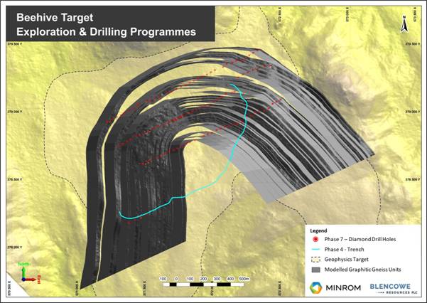
Figure 2: Beehive block model / grade model illustrating continuity within the modelled area.
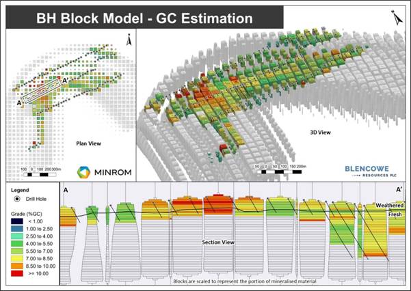
Block model of the Beehive Deposit. Mineralisation remains open along strike and at depth; multiple drill holes end in mineralisation.
Table 1: Orom-Cross JORC Mineral Resource Summary by Deposit (JORC 2012; 3.5% TGC cut-off).
Northern Syncline + Camp Lode + Iyan + Beehive = 64.3 Mt.
|
Deposit |
Measured (Mt) |
Indicated (Mt) |
Inferred (Mt) |
Total (Mt) |
Grade |
|
Northern Syncline |
1.20 |
14.19 |
8.14 |
23.53 |
5.4% |
|
Camp Lode |
– |
2.22 |
0.36 |
2.58 |
6.9% |
|
Iyan |
– |
– |
16.90 |
16.90 |
6.0% |
|
Beehive |
– |
– |
21.30 |
21.30 |
6.6% |
|
Total Orom-Cross |
1.20 |
16.41 |
46.70 |
64.30* |
6.0% |
*Totals subject to rounding. Category splits and grade weighting are as reported by the Competent Person.
Ore Reserves remain unchanged and are presented separately below.
Table 2: Orom-Cross Ore Reserve Summary (unchanged, JORC 2012)
Northern Syncline + Camp Lode only.
|
Deposit |
Ore Reserve (Mt) |
Grade (%TGC) |
|
Northern Syncline |
20.59 |
4.99 |
|
Camp Lode |
2.49 |
6.74 |
|
Total Ore Reserve |
23.08 |
5.18 |
Ore Reserves are a subset of Mineral Resources and are not additive to the JORC Mineral Resource total. Both Iyan and Beehive deposits are currently reported as a maiden JORC Mineral Resource only and have not yet been converted to Ore Reserves. Further infill drilling is required to bring a portion of both Iyan and Beehive Resources into Reserves.
JORC Mineral Resource Upgrade Confirms Scale and Upside
The maiden Beehive JORC Mineral Resource confirms a thick graphite system at shallow depths within the modelled area, while previously reported deep drilling demonstrates mineralisation continuing to approximately 100 metres depth. Beehive has been modelled largely within the upper 25-30 metres and over only part of the target anomaly, and the Company believes there is clear scope for resource growth through step-outs and further modelling.
Key implications of the upgrade:
· Step-change in scale: Beehive lifts total Orom-Cross JORC Mineral Resources to 64.3 Mt; reinforcing a multi-deposit, long-life, large-scale graphite development
· Resource growth runway: mineralisation remains open beyond the current modelled area, with step-out and depth upside indicated by drilling to date
· Development and mineability: continuity and near-surface thickness support open-pit development assumptions and low strip potential, consistent with a low-cost mining profile
· Metallurgical alignment: grade profile and mineralisation style remain consistent with prior testwork and current processing assumptions
· Efficient conversion: conversion expenditure remains comparatively low, supporting continued definition of additional tonnes and the potential to upgrade classifications as modelling progresses
With a materially expanded inventory now defined, the Company has been progressing further DFS optimisation work to incorporate the enlarged resource base, evolving downstream pathways, and ongoing commercial discussions.
Strategic offtake and funding discussions also continue alongside development planning, and the Company will provide updates as and when disclosure is permitted and appropriate, in line with its regulatory obligations.
CEO Interview
Blencowe Resources CEO, Mike Ralston discusses today’s JORC Resource upgrade and the Company’s current workstreams in an interview linked below:
https://media.focusir.com/BlencoweRes_Orom-Cross_Resource_Growth_Update
Blencowe Resources Executive Chairman, Cameron Pearce commented:
“Today’s maiden Beehive JORC Mineral Resource is another major step forward for Orom-Cross. Beehive adds 21.3 million near-surface tonnes at 6.6% TGC, lifting total Orom-Cross JORC Mineral Resources to 64.3 million tonnes across Northern Syncline, Camp Lode, Iyan and Beehive.
Importantly, Beehive has been modelled over only 22% of the target anomaly and largely within the upper 25-30 metres, while deep drilling has demonstrated mineralisation continuing to below 100 metres depth. We believe this provides a clear growth runway beyond the current modelled area.
With a materially expanded inventory now defined, we have been progressing further DFS optimisation work and expect to update the market prior to the end of Q2 2026. Strategic, offtake and funding discussions remain ongoing and we will update the market as appropriate.”
Competent Person’s Statement
The information in this release, which is related to Mineral Resource estimation, was compiled under the supervision of Mr Oscar Van Antwerpen who is the CEO of Minrom Consulting (Pty) Ltd; he is Member of the Geological Society of South Africa (GSSA) and a Registered Professional Natural Scientist (Pr.Sci.Nat) with the South African Council for Natural Scientific Professions (SACNASP).
Mr Oscar Van Antwerpen has sufficient experience relevant to the style of mineralisation and type of deposit under consideration and to the activity that he has undertaken to qualify as a Competent Person as defined by the JORC (2012) Code. Mr Oscar Van Antwerpen consents to the inclusion in this report of the matters based on his information in the form and context in which it appears.
Appendix
(Independent Geologist – Minrom – tables and figures)
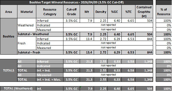
· GC – Graphitic carbon, TC – Total carbon.
· No geological losses applied.
· A conservative cut-off grade of 3.5% GC has been applied based on metallurgical testing & preliminary mining parameters.
· Mineralised tonnes have been rounded off and contained graphite tonnages have been rounded off to the nearest 1000 (Kt).
· Contained graphite has been reported without the application of cut-off grades, loss factors, or beneficiation yields.
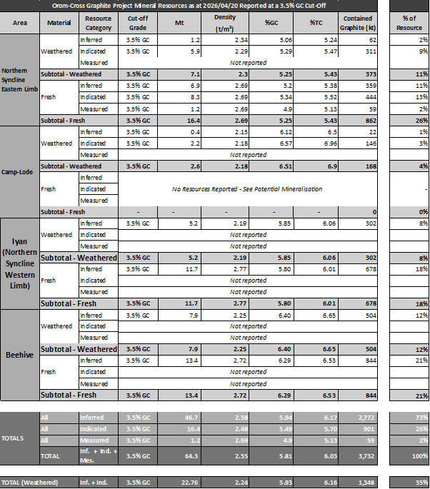
· GC – Graphitic carbon, TC – Total carbon.
· No geological losses applied.
· A conservative cut-off grade of 3.5% GC has been applied based on metallurgical testing & preliminary mining parameters.
· Mineralised tonnes have been rounded off and contained graphite tonnages have been rounded off to the nearest 1000 (Kt).
· Contained graphite has been reported without the application of cut-off grades, loss factors, or beneficiation yields.
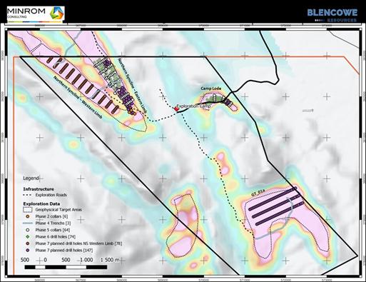
Map 1: Showing the 4x Orom-Cross deposits, including Camp Lode, Northern Syncline, and new Iyan (NS western limb) and Beehive (GT 01a) deposits.
**ENDS**
For further information please contact:
|
Blencowe Resources Plc |
|
|
Sam Quinn (Director) |
Tel: +44 (0)1624 681 250
|
|
Sasha Sethi (Investor Relations) |
Tel: +44 (0) 7891 677 441 |
|
Tavira Financial (Joint Broker):
Jonathan Evans |
Tel: +44 (0)20 3192 1733 |
|
Oak Securities (Joint Broker):
Calvin Man /Mungo Sheehan / Jerry Keen |
Tel: +44 (0)20 3973 3678 |
|
|
|
|
|
#GRX GreenX Metals Limited – Quarterly Activities Report March 2026
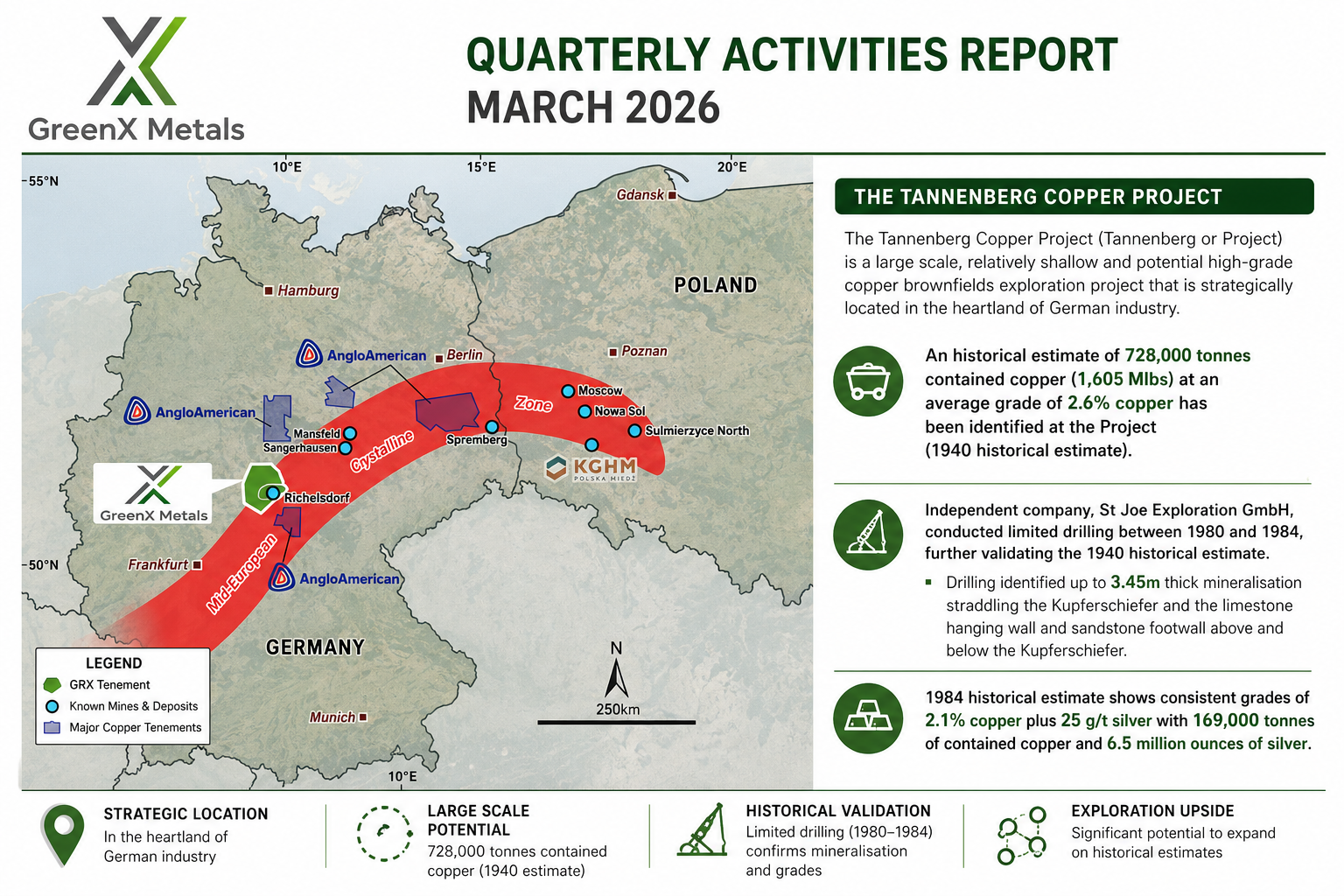 GreenX Metals Limited (ASX:GRX, LSE:GRX, GPW:GRX, Germany-FSE:A3C9JR) (GreenX or the Company) is pleased to present its Quarterly Activities Report for the period ending and subsequent to 31 March 2026.
SUMMARY
· TANNENBERG COPPER PROJECT (GERMANY)
o The Tannenberg Copper Project (Tannenberg or Project) is a large scale, relatively shallow and potential high-grade copper brownfields exploration project that is strategically located in the heartland of German industry.
o An historical estimate of 728,000 tonnes contained copper (1,605 Mlbs) at an average grade of 2.6% copper has been identified at the Project (1940 historical estimate).
o Independent company, St Joe Exploration GmbH, conducted limited drilling between 1980 and 1984, further validating the 1940 historical estimate.
§ Drilling identified up to 3.45m thick mineralisation straddling the Kupferschiefer and the limestone hanging wall and sandstone footwall above and below the Kupferschiefer.
§ 1984 historical estimate shows consistent grades of 2.1% copper plus 25 g/t silver with 169,000 tonnes of contained copper and 6.5 million ounces of silver.
o Exploration upside potential under modern interpretation: St Joe Exploration confirmed thicker widths of copper and silver mineralisation at Ronshausen, and more may exist up to 30m above and 60m below the Kupferschiefer in the limestone hanging wall and sandstone footwall.
o Cautionary statement: The historical estimates in this announcement are not reported in accordance with the JORC Code (2012) (JORC Code). A competent person has not done sufficient work to classify the historical estimate as a mineral resource or ore reserve in accordance with the JORC Code. It is uncertain that following evaluation and/or further exploration work that the historical estimate will be able to be reported as a mineral resource or ore reserve in accordance with the JORC Code
o Significant ongoing work program: GreenX is progressing with an integrated program at Tannenberg to support future JORC Code reporting, including, continued reprocessing/interpretation of historical datasets, investigations to re-access historical underground workings to conduct in-situ sampling, and advancing plans for drilling to verify historical estimates and prove up extensions to known mineralisation to underpin a future Mineral Resource Estimate.
o During the quarter, GreenX was invited to the European Parliament in Brussels to present the Tannenberg Project to a contingent of Members of the European Parliament and officials representing the EU Critical Raw Materials Committee. The invitation highlights the growing recognition across Europe, and in Germany, of the importance of supporting domestic resource projects, such as Tannenberg, that can contribute to strengthening strategic autonomy and improving the resilience of critical raw materials supply chains.
o The Company notes that Lumina Metals Corp. (Lumina) is completing an initial public offering (IPO) to list on the Toronto Stock Exchange (TSX), with Lumina also seeking admission to the Warsaw Stock Exchange (WSE) in Poland. The IPO was oversubscribed with Lumina raising C$406 million, implying a fully diluted valuation of approximately C$1.4 billion. The IPO was supported by BMO Capital Markets, National Bank Financial Inc., Morgan Stanley Canada Limited, RBC Capital Markets and CIBC World Markets Inc., with participation from North American and European investors (including Polish and German investors). Lumina’s projects are Kupferschiefer-type deposits hosted within the same prolific copper belt that extends westward into Germany and hosts GreenX’s Tannenberg Project.
· ELEONORE NORTH PROJECT (GREENLAND)
o Outcropping gold and high-grade antimony mineralisation now confirmed at the Noa Prospect within the Eleonore North Project (Eleonore North or ELN) in East Greenland.
o High-grade tungsten and antimony mineralisation also identified in historical estimate at the Margeries Prospects within the Eleonore North project:
§ 83kt of mineralised rock with a mean grade of 4.6% Sb at North Margeries.
§ 58kt of mineralised rock grading at 3.2% W at South Margeries o.
§ 32kt of mineralised rock grading at 1% W at North Margeries.
o Potential to identify large scale deposits in new underexplored province with gold mineralisation associated with quartz veining at surface over a length of up to 15 km
o Field activities initially focusing on the shallow gold and high-grade tungsten and antimony potential are currently being finalised for mid-2026.
o Cautionary statement: The Historical Estimates in this announcement are not reported in accordance with the JORC Code. A competent person has not done sufficient work to classify the Historical Estimate as a mineral resource or ore reserve in accordance with the JORC Code. It is uncertain that following evaluation and/or further exploration work that the Historical Estimate will be able to be reported as a mineral resource or ore reserve in accordance with the JORC Code.
o GreenX is finalising the 2026 exploration programme to define and prioritise drill targets, including processing the historical hyperspectral survey and undertaking field mapping/sampling at Noa to ground-truth “reduced intrusion-related gold system” (RIRGS) targets; and at Margeries, collecting bulk samples for W/Sb metallurgical sighter test work, reviewing archived core for re-analysis/metallurgical sampling, and reprocessing historic geophysics/hyperspectral data alongside field mapping to generate drill targets
· SINGAPORE COURT DISMISSED POLAND’S SET-ASIDE APPLICATION
o During the quarter, the Singapore International Commercial Court of the Republic of Singapore (Singapore Court) issued a judgment rejecting, in its entirety, Poland’s application to set-aside the Energy Charter Treaty (ECT) award.
o Following the Singapore Court’s rejection of Poland’s ECT set-aside motion, the Company was awarded ~A$1.6 million by the Singapore Court, payable by Poland, fully reimbursing GreenX for all its legal costs claimed in defending Poland’s failed ECT set-aside motion. The A$1.6 million has now been paid by Poland in full.
o The Company is currently preparing for enforcement activities of the ECT award following the Singapore Court’s rejection of Poland’s ECT set-aside motion.
· CORPORATE
o During the quarter, the Company successfully completed a placement to raise gross proceeds of approximately A$13.6 million.
o Funds from the placement will be used for exploration and development activities at Tannenberg and at Eleonore North, and for general working capital, including costs in relation to the Company’s ongoing set-aside proceedings against Poland.
ENQUIRIES
|
Ben Stoikovich Chief Executive Officer
+44 207 478 3900 |
Kazimierz Chojna Investor Relations – Poland
Kim Eckhof Investor Relations – UK / Germany |
#FCM First Class Metals PLC – Bonanza Gold Intercept at Roy, Sunbeam
 First Class Metals PLC (“First Class Metals”, “FCM” or the “Company”) the UK listed company focused on the discovery of economic metal deposits across its exploration properties in Ontario, Canada, is pleased to report initial drill results for holes 1-4 and provisionals for holes 5 and 6 from the drilling at the Roy prospect on the Sunbeam Property.
Highlights
- Bonanza-grade gold intersected in drill hole SUN-26-05, with visible gold observed, highlighting the presence of a high-grade mineralising system
- Provisional Fires assays (“FA”) results have been received from holes SUN-26 01 to 04
- Provisional Photon assay results confirm high-grade gold in holes SUN-26-05 and 06, including the standout bonanza intercept
- Results prove that the Roy lineament is a gold bearing structure, validating the Company’s geological model.
- The drilling has demonstrated geological continuity over >250m of strike, supporting potential for scale along the structure.
- Logging is completed and drill hole interpretation started.
- Very Low Frequency (“VLF”) survey identifies multiple additional conductive targets along strike at Roy.
- The Roy VLF survey to be extended to the northeast to test further strike extensions and unlock additional potential
- VLF survey to commence at Pettigrew early May, targeting a parallel mineralised structure
- Additional assay results pending, with further updates to follow as results are received
Marc J. Sale CEO First Class Metals Commented:
“The initial assay results from the drilling at Roy have vindicated our belief that the Sunbeam property contains significant gold potential. The drilling at Roy has tested only 1% of the known strike extent of the mineralised lineaments. To put Roy in perspective one must recall that Hammond Reef, only 10km to the northwest, has an average grade of 0.84g/t gold, with no reported ‘high grade’. At Roy we have identified low grade zones as well as importantly bonanza grade gold values. I feel confident that, as we grow our understanding based on the information generated by FCM’s new approach at Roy we can not only upgrade the Roy values but mirror this across the property.”
https://firstclassmetalsplc.com/link/Pmddar
Roy structure
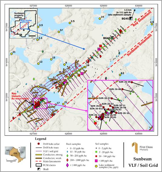
The lineament that the Roy occurrence / development is located on is a district scale structure. It has now been traced through historic work and prospecting by Emerald Geological Services (“EGS”) towards the 111ppb lake sediment sample, some 5km northeast along strike of the Roy mine shaft. The structure also hosts historic shafts B43 and B45. The recent VLF interpretation shows multiple conductors sub parallel to the Roy trend, which further enhances the potential, see Figure 1.
Figure 1 Showing the soil (and coincident VLF) grid, locations of historic shafts, including Roy, and drill holes around the Roy shaft as well as the strike extension to the NE.
Drill results
The Fire Assay for the first four drill holes have been received.
The initial hole which attempted to twin the historic drill hole (SP-11-12 4g/t Au over 1.85m) contained ~2m @1.3g/t Au; the second hole contained 1.1m @ 2.3g/t. Holes three and four both contained a metre at roughly 0.5g/t Au.
The photon assay results have also been received for the three sections of core with reported VG.
Hole 06 (second reported dual occurrence of VG) contained two consecutive samples giving 0.6m @ 2.2g/t Au. Significantly hole 05 which contained the initial report of VG, returned 0.3m @ 45g/t gold which would equate to almost 5 ounces of gold over one metre, 150g/m (gram metres).
Figure 2 Showing the initially reported VG in hole 05, with strong association to galena (lead mineral).
The fire assays for holes 05 and 06 are still to be received, given the coarse nature of the gold and the different quite distinctive assay methods some discrepancy with the photon assays are expected.
Initial plots of the anomalous gold assay result confirm the continuity of the mineralised package over >150m, see Figure 3.
All 12 holes intersected the targeted ‘structure’ or the potentially mineralised package which is now confirmed over a strike length exceeding 300m, see Figure 3 and remains open along strike to the northeast and southwest.
Figure 3 showing the 12 drill holes at Roy with initial interpretation of the potentially mineralised package which extends over 300m.
The initial 4 drill hole results, all contain anomalous to +2g/t Au and are considered encouraging. Even more so give the bonanza value in the photon assay of almost one and a half ounces in hole 05.
The strike extent of the drilling covers ~300m but the soil sampling (and in part VLF) grid extends over 1,500m to the northwest. A highly anomalous lake sediment sample collect in 2023 containing 111ppb Au is a further 1,500m along strike from the end of the soil grid. There is also a string of grab samples along strike to the southwest with a +1ppm samples 5 km along strike. All these factors continue to build up the expectation of a +10km mineralised structure. The Roy lineament is one of three structures on the Sunbeam property with proven gold occurrences.
The initial results from the LiDAR study have shown the Roy lineament is a very robust structure. It is intended to extend the VLF grid to cover the northern soil survey area and potentially. Provisionally both could be extended further to the northeast.
The visible gold is seen in association with galena, potentially an important pathfinder. The lead (Pb) and gold when plotted on the soil grid indicate several ‘bullseyes’ along strike where highly anomalous Au and Pb assay results are recorded, see Figure 4
Figure 4 showing the coincident Pb and Au anomalism.
Work is ongoing integrating the VLF, LiDAR and geochemistry with the local geology and structure.
As the weather is steadily improving in northwest Ontario, the ‘thaw’ heralds the start of the field season. Work will continue at Roy as described above and it is intended to undertake work on the parallel lineament that hosts the Pettigrew development. Historic drilling by TerraX produced 19.4 g/t Au over 0.63m and 15.17 g/t over 1.37m in two zones separated by 15m in hole 57751. Channel and grab samples from FCM exploration have returned significant gold grades, including:13.0 g/t Au grab sample from quartz rubble dug up beside the stripped outcrop. 3.5 g/t Au in a channel over 0.2m in a quartz vein (with galena and chalcopyrite); 1.82 g/t Au in a channel over 0.75m in sheared porphyry.
The growing understanding of the structural controls to the mineralisation gleamed from the ongoing work at Roy will be used to explore the area immediately around the Pettigrew shafts and pits as this zone is all-weather accessible.
Qualified Person
The technical disclosures contained in this announcement have been drafted in line with the Canadian Institute of Mining, Metallurgy and Petroleum standards and guidelines and approved by Marc J. Sale, who has more than 30 years in the gold exploration industry and is considered a Qualified Person owing to his status as a Fellow of the Australian Institute of Mining and Metallurgy.
Glossary of Technical Terms
| Term | Explanation |
| Alteration | Chemical changes to rock caused by mineralising fluids, often associated with ore-forming processes. |
| Bonanza Gold | A Bonanza gold grade refers to exceptionally high-concentration gold ore, typically exceeding 34 grams per tonne (g/t) or over 1 troy ounce per ton (opt). These rare, high-value deposits often feature visible gold |
| Core | Cylindrical rock recovered during diamond drilling, used to examine geology and mineralisation. |
| Drill Hole | A hole drilled into the ground to obtain rock samples (core) for geological logging, sampling and analysis. |
| Galena | A lead sulphide mineral (PbS) that can be associated with precious metal mineralisation in some geological systems. |
| Logging | The detailed geological description and recording of drill core, including rock type, alteration and mineralisation. |
| Mineralised Package | A sequence of rocks containing minerals associated with potential economic metal deposits. |
| Schist | A metamorphic rock characterised by strong foliation and alignment of minerals. |
| Sampling | The process of cutting and collecting sections of drill core for laboratory analysis to determine metal content. |
| Structure / Structural Zone | A geological feature such as a fault or shear zone that may control the movement of mineralising fluids and the location of mineral deposits. |
| Assay | Laboratory analysis used to determine the concentration of metals within a rock sample. |
| Quartz Vein | A fracture or crack in rock that has been filled with quartz. Quartz veins are commonly associated with gold mineralisation. |
| Strike Length | The horizontal distance over which a geological structure or mineralised zone can be traced. |
| Tonalite | A coarse-grained intrusive igneous rock similar to granite, commonly found in mineralised geological terranes. |
| Visible Gold (VG) | Gold that can be seen with the naked eye in drill core or rock samples. Visible gold does not necessarily indicate economic grades but is considered a positive indicator in gold exploration. |
For Further Information:
Engage with us by asking questions, watching video summaries, and seeing what other shareholders have to say. Navigate to our Interactive Investor hub here:
https:www.firstclassmetalsplc.com
For further information, please contact:
James Knowles, Executive Chair
Email: JamesK@Firstclassmetalsplc.com
Tel: 07488 362641
Marc J Sale, CEO
Email: MarcS@Firstclassmetalsplc.com
Tel: 07711 093532
AlbR Capital Limited
David Coffman / Dan Harris
Website: www.albrcapital.com
Tel: (0)20 7469 0930
Axis Capital Markets (Broker)
Lewis Jones
Website: Axcap247.com
Tel: (0)203 026 0449
#SVML Sovereign Metals LTD – Kasiya MRE Significantly Upgraded Ahead of DFS
 KEY HIGHLIGHTS
· Total Rutile Mineral Resource increases to 2.1 billion tonnes at 0.96% rutile for 20.3Mt contained rutile with 0.95% TGC for 20.0Mt contained graphite (M,I&I)
· Measured and Indicated (M&I) contained rutile surges 32% to 16.1Mt (1.6 billion tonnes at 0.98% rutile) – a material increase in resource confidence ahead of DFS
· Measured Resource planned to be mined and processed in first six years of operations – highest confidence JORC Code category, achieved at Kasiya for the first time
· Resource upgrade delivers the classification standard required for bankable DFS – a critical milestone on the path to project financing
Sovereign Metals Limited (ASX:SVM; AIM:SVML; OTCQX:SVMLF) (Sovereign or the Company) is pleased to announce an updated Mineral Resource Estimate (MRE) for its flagship Kasiya Rutile-Graphite Project (Kasiya or Project) in Malawi.
The updated MRE will serve as the resource base for the Kasiya Definitive Feasibility Study (DFS) mine schedule, replacing the previous April 2023 MRE (Previous MRE).
Combined Measured and Indicated rutile Resources have grown 38% to 1,652Mt, now representing 77% of the total Resource base. This material improvement in Resource confidence reflects the extensive infill drilling programs completed and provides a robust foundation for the forthcoming DFS. Importantly, Kasiya has achieved a Measured Resource for the first time, which represents at least the first six years of planned operations.
Managing Director and CEO Frank Eagar commented:
“This updated MRE is a significant milestone for Sovereign as we advance Kasiya through the Definitive Feasibility Study. The 32% increase in Measured and Indicated contained rutile, together with our first-ever Measured Resource, reflects both the quality of our geological dataset and the exceptional nature of this deposit. The rigour of the updated resource estimation gives our strategic and commercial partners and us high confidence in the resource base underpinning our potential mine schedule. Kasiya remains unmatched globally as a source of natural rutile, and this MRE update reinforces its potential as a long-life, low-cost supplier to critical global supply chains.”
UPDATED MINERAL RESOURCE ESTIMATE
Table 1: Kasiya Rutile Mineral Resource Estimate (March 2026)
|
Class |
Tonnes (Mt) |
Rutile Grade (%) |
Rutile (Mt) |
TGC (%) |
TGC (Mt) |
Rutile Eq. (%) |
|
Measured |
107 |
1.05 |
1.12 |
1.56 |
1.67 |
1.94 |
|
Indicated |
1,545 |
0.97 |
14.99 |
1.05 |
16.26 |
1.57 |
|
Total M&I |
1,652 |
0.98 |
16.12 |
1.09 |
17.93 |
1.60 |
|
Inferred |
452 |
0.91 |
4.12 |
0.45 |
2.02 |
1.17 |
|
Total Rutile MRE |
2,105 |
0.96 |
20.24 |
0.95 |
19.95 |
1.51 |
Note: Rutile Mineral Resource defined from a pit shell with mineralisation defined as >= 0.75% Rut95 for the pit shell optimisation run. A rutile concentrate net price of US$1,400 was used to determine economic value. Graphite had no value for this run. The Rutile MRE is reported based on all rutile mineralisation >=0.4% Rut95 within the optimised pit shell. Any apparent differences in totals are due to rounding.
Table 2: MRE Comparison – Previous vs. Updated
|
Metric |
Previous MRE |
Updated MRE |
Change |
|
Total Resource Tonnes (Mt) |
1,809 |
2,105 |
+16% |
|
Measured & Indicated Tonnes (Mt) |
1,200 |
1,652 |
+38% |
|
M&I Contained Rutile (Mt) |
12.2 |
16.1 |
+32% |
|
Total Contained Rutile (Mt) |
17.9 |
20.2 |
+13% |
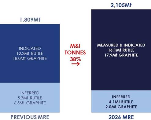
Figure 1: Increase in Kasiya MRE across categories
The updated MRE provides the resource foundation for the upcoming DFS mine schedule and mine optimisation study. The step-up in Measured and Indicated resource confidence is a critical input for the DFS, enabling the Company to present a resource base with the classification level required for bankable project financing and offtake discussions.
Sovereign’s DFS is progressing across all workstreams including mining, processing, infrastructure, environmental and social studies, and commercial arrangements.
MRE EMPHASISES SOVEREIGN’S STRATEGIC SIGNIFICANCE FOR GLOBAL SUPPLY CHAINS
Kasiya is a uniquely diversified source of critical minerals essential to defence, industrial and energy security. The updated MRE demonstrates Kasiya’s potential to supply titanium-bearing rutile and graphite for several decades and its position as the world’s single most strategically important source of rutile.
Natural rutile is a critical mineral essential to titanium metal production for aerospace, defence and medical applications. According to leading titanium consultants TZ Minerals International Pty Ltd (TZMI), demand for rutile from the titanium metals industry is forecast to grow 3% annually, while global supply is expected to decline by 7% per year over the next decade. The market faces a widening structural deficit.
Natural rutile commands a significant premium over alternative titanium feedstocks due to its superior grade (95%+ TiO₂), lower processing costs, and smaller environmental footprint. With no meaningful domestic production in key consuming nations, Kasiya‘s scale and quality position it as the single most strategically important source of natural rutile outside of current producing regions.
With the updated MRE, Kasiya is positioned to address this critical supply gap at a time when new sources of natural rutile are urgently needed.
The graphite resource further enhances Kasiya’s strategic value with a second critical mineral. With graphite demand forecast to grow 9% annually across battery and industrial applications (Benchmark Mineral Intelligence), the Project’s 20.0Mt contained graphite provides significant exposure to a valuable by-product.
KASIYA MRE TECHNICAL DETAILS
The Kasiya MRE has been prepared by Sovereign under guidance by MSA Group and is reported in accordance with the JORC Code (2012) (JORC).
Rutile mineralisation lies in laterally extensive, near-surface, flat “blanket” style bodies in areas where the weathering profile is preserved and not significantly eroded. The high-grade zones are relatively geologically consistent with limited variability along and across strike. The mineralisation style is illustrated best in Figure 2 below.
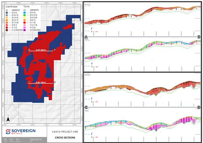
Figure 2: MRE with E-W Cross Sections 8,479,200N (A-B) and E-W Cross Sections 8,467,600N (C-D) (cross section are at +/- 100m with 30x vertical exaggeration)
SUMMARY OF RESOURCE ESTIMATE REPORTING CRITERIA
As per ASX Listing Rule 5.8 and the JORC reporting guidelines, a summary of the material information used to estimate the MRE is detailed below.
Geology
Regional Geology
The greater part of Malawi is underlain by crystalline Precambrian to lower Palaeozoic rocks referred to as the Malawi Basement Complex. In some parts, these rocks have been overlain unconformably by sedimentary and volcanic rocks ranging in age from Permo-Triassic to Quaternary. The Basement complex has undergone a prolonged structural and metamorphic history dominated by uplift and faulting, resulting in the formation of the Malawi Rift Valley.
Kasiya is located on the Lilongwe Plain, which is underlain by the Basement Complex paragneisses and orthogneisses, which are part of the Mozambique Belt. The bulk of the gneisses are semi-pelitic, but there are bands of psammitic and calcareous rocks that have been metamorphosed under high pressure and temperature conditions to granulite facies.
Interspersed within the paragneiss units are lesser orthogneisses, often cropping out as conspicuous tors, as well as amphibolites, pegmatites and minor mafic to ultramafic intrusions. Foliation and banding in the gneisses have a broad north-south strike over the general area. Thick residual soils and pedolith with some alluvium overlie the gneisses and include sandy, lateritic and dambo types.
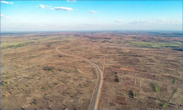
Figure 3: Drone photo above the Kasiya Deposit showing the open, flat terrain
Project Geology
Sovereign’s tenure covers 644 km2 over an area to the north, west and south of Malawi’s capital city, covering the Lilongwe Plain. The topography is generally flat to gently undulating, and the underlying geology is dominated by paragneiss with pelitic, psammitic and calcareous units.
A particular paragneiss unit is rich in rutile and graphite and is the primary source of both minerals in the area. This area was deeply weathered during the Tertiary, and rutile concentrated in the upper part of the weathering profile, forming residual placers, such as the Kasiya deposit. Once this material is incised and eroded, it is transported and deposited into wide, regional braided river systems, forming alluvial heavy mineral placers such as the Bua Channel.
Kasiya Deposit Geology
The high-grade rutile deposit at Kasiya is best described as a residual placer, or otherwise known as an eluvial heavy mineral deposit. It is formed by weathering of the primary host rock and concentration in place of heavy minerals, as opposed to the high-energy transport and concentration of heavy minerals in a traditional placer.
The presence of abundant kyanite and graphite in the host material suggests a meta-sedimentary protolith. The protolith likely started with a 0.5-1.5Ga basin that also experienced a consistent influx of titanium minerals.
These sedimentary rocks were subject to granulite facies metamorphism under reduced conditions in the Pan-African Orogeny. The metamorphic facies, reduced environment, relatively high titanium content and low iron content resulted in rutile being the most stable titanium mineral under these conditions. Slow exhumation and cooling then resulted in re-crystallisation as paragneisses containing coarse rutile and graphite.
The final and most important stage of rutile enrichment came as tropical weathering during the Tertiary depleted the top ~8m of physically and chemically mobile minerals. This caused significant volume loss and concurrent concentration of heavy resistate minerals, including rutile and kyanite.
Rutile mineralisation therefore lies in laterally extensive, near-surface, flat “blanket” style bodies in areas where the weathering profile is preserved. The Kasiya deposit shows widespread, high-grade mineralisation commonly grading 1.2% to 2.0% rutile in the top 3-5m from surface. Moderate grade mineralisation, generally grading 0.5% to 1.2% rutile, commonly extends from 5m to the base of the soft saprolite unit to typically 20-30m depth, where it terminates on the hard saprock basement.
Graphite generally occurs in broad association with rutile. However, it is depleted in the top 3-5m and therefore can often show an inverse grade relationship with rutile in the near-surface zones. At depths generally greater than 5m, graphite is not depleted, and rutile is not particularly enriched, so a more consistent grade relationship exists.
Drilling Techniques
Spiral hand-auger (HA) drilling, Push-tube and/or diamond core (PTDD), and Air core (AC) drilling methods have been used extensively at the Kasiya deposit by Sovereign to define mineralisation and to obtain quantitative rutile and graphite (TGC) assay information.
HA drilling was executed by Sovereign field teams using a manually operated enclosed-flight Spiral Auger (SP / SOS) system produced by Dormer Engineering in Queensland, Australia. The HA bits are 62mm and 75mm in diameter with 1m long steel rods. Each 1m of drill advance is withdrawn and the contents of the auger flight removed into bags and set aside. An additional 1m steel rod is attached and the open hole is re-entered to drill the next metre. This is repeated until the drill hole is terminated often due to the water table being reached or due to bit refusal. The auger bits and flights are cleaned between each metre of sampling to avoid contamination.
PTDD drilling is undertaken using a drop hammer Dando Terrier MK1 and a drop hammer DL650 by Geo-consult and Thompsons Drilling. The drilling generated 1m runs of 88mm PQ core in the first 2m and then transition to 61mm core for the remainder of the hole. Core drilling is oriented vertically by spirit level.
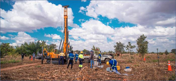
Figure 4: Core drilling (push tube) in action at Kasiya
AC drilling was completed by Thompson Drilling utilising a Smith Capital 10R3H compact track-mounted drill. The drilling is vertical and generates 1m samples with care taken in the top metres to ensure good recoveries of the high-grade surface material. The AC sample is collected by the on-board cyclone into heavy-duty RC sample bags. Drilling continues until bit refusal onto basement ~20-30m. Sample bags are immediately transported back to Sovereign’s field laydown yard where they are processed. AC drilling is on a nominal 200m by 200m pattern.
The drilling programs to date show a surface mineralised extent, defined nominally by a 0.7% rutile cut-off, of approximately 268.6 km2 with numerous areas of high-grade rutile and graphite defined.
The PTDD and AC twin and density sample holes are selectively placed throughout the deposit to ensure a broad geographical and lithological coverage for the analysis.
MSA has reviewed Standard Operating Procedures (SOPs) for HA, SA, PTDD and AC drilling and found them to be fit for purpose and support the resource classifications as applied to the MRE.
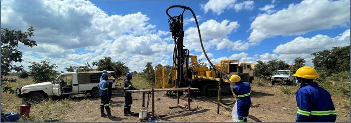
Figure 5: Air-core (AC) drilling at Kasiya in May 2022.
Sampling Techniques
HA samples are obtained at 1m intervals generating on average approximately 2.5kg of drill sample. HA samples are manually removed from the auger bit and sample recovery is visually assessed in the field. As samples become wet at the water table and recovery per metre declines, the drill hole is terminated. Each 1m sample is sun dried, logged and weighed. HA samples are composited based on regolith weathering boundaries defined by geology logging. Each 1m of sample is dried, lightly pressed to remove soft aggregates and riffle-split to generate a total sample weight of 3kg for analysis, generally at 2 – 5m intervals. This primary sample is then riffle split again to provide a 1.5kg sample each for rutile and graphite analyses.
SA samples are bulk spiral auger samples primarily designed to collect a large sample for metallurgical and pilot plant testwork. Bit sizes range from 300 mm to 700mm diameter. The samples are collected on 1m intervals, laid out on a large tarpaulin to be sun dried before using a cone and quarter method (for the 700mm diameter) to produce a roughly 100kg sample which is then riffle split to produce a 3kg sample, with the file split providing 1.5 kg each for rutile and graphite analysis. Samples are analysed in 1m intervals.
PTDD samples are predominantly from HQ sized core (61mm diameter). Half core 1m samples are sun dried, logged and weighed. Samples are then lightly pressed and composited over 2m intervals. An equal mass is taken from each contributing metre to generate a 1.5kg composite sample. Individual recoveries of core samples are recorded on a quantitative basis. Core recovery is very good overall at >95%.
AC samples are collected in 1m increments. AC samples are dried, riffle split, lightly pressed and composited. Samples are collected and homogenised prior to splitting to ensure sample representivity. ~1.5kg composite samples were defined by the regolith boundaries in earlier drilling. More recent AC drilling utilised regular 2m downhole composites. An equivalent mass is taken from each primary sample to make up the composite.
During 2024 twin drilling campaigns, samples were processed at 1m intervals to get a better understanding of drilling and deposit variability.
The sampling and compositing methods described are considered appropriate and reliable based on accepted industry practice. MSA completed an on-site audit of sampling and sample processing and deemed the processes fit for purpose.
Sample Analysis Methodology
All samples arrive at Sovereign’s Malawi laboratory where they are sorted and checked in. Graphite samples are identified and prepared for export, while the equivalent rutile samples begin the sample workflow to generate the rutile non-magnetic concentrate (NM) for export for TiO2 and multi-element XRF analysis. Prior to June 2024 XRF analysis was completed at ALS Perth, Western Australia, currently Scientific Services South Africa (SS) laboratory in Cape Town, South Africa is being used. Umpire checks have shown good correlation between the two external laboratories. Audit of Sovereign’s laboratory premises, staff, sample analysis and QA procedures was completed by MSA during two site visits in 2024 and 2025.
SVM Malawi Laboratory Rutile Workflow
· Samples are dried in a commercial oven for 1 hour at 105℃ and a dry raw samples mass is recorded.
· Samples are soaked in 1% Tetrasodium pyrophosphate (TSPP) solution overnight and then lightly agitated prior to wet screening.
· Wet screening occurs at 5mm, 600µm and 45µm to remove oversize and slimes (-45µm) material. Each +45µm retained fraction is dried, logged and weighed.
· The resulting sand fraction +45µm -600mm is oven dried for 1 hour at 105℃ after which its dry weight is recorded.
· The sand fraction is then passed over a Gemeni wet shaking table at a constant feed rate to generate a heavy mineral concentrate (HMC).
· Heavy Liquid Separation (HLS) at Diamantina Laboratories in Perth was initially trialled as a preferred separation method but was quickly superseded (supported by QA analysis) by wet-table separation on account of substantial near-density gangue material reporting to the HM sink for the HLS technique. The HLS analyses represent 6% of the MRE assay dataset.
· The wet-tabled HMC is then subject to magnetic separation @ 16,800G (2.9Amps), producing a magnetic (Mag) and non-magnetic (NMag) fraction. The separation is performed using a Mineral Technologies Reading Pilot IRM (Induced Roll Magnetic) purchased by Sovereign and located at the Company’s laboratory in Malawi. Pre-2022, this step was completed by Allied Mineral Laboratories Perth (AML) in Perth, Western Australia.
The Malawi onsite laboratory sample preparation methods are considered quantitative to the point where the NMag concentrate (containing the rutile) is produced. Several generations of QEMSCAN analysis of the NMag and Mag fractions performed at ALS Metallurgy show dominantly clean and liberated rutile grains and confirm that rutile is the only titanium species in the NMag fraction.
Recovered rutile is defined and reported here as: TiO2 recovered in the SAND +45 to -600um range to the NMag concentrate fraction as a % of the total primary, dry, raw sample mass divided by 95% (to represent an approximation of final product specifications). i.e recoverable rutile within the whole sample.
Graphite Testwork
Once secured the 1.5kg graphite sample are delivered to Intertek Group plc (Intertek) in Johannesburg, South Africa, 750g of each 1.5kg graphite sample is pulverised to -75um with a 150g dissolved in dilute hydrochloric acid to liberate carbonate carbon. The solution is filtered using a filter paper, and the collected residue is then dried to 425°C in a muffle oven to drive off organic carbon.
The 150g dried sample is transported to Perth, Australia where it is then combusted in an Eltra CS-800 induction furnace infra-red CS analyser to yield total graphitic or elemental carbon (TGC).
QAQC
Accuracy monitoring is achieved through submission of certified reference materials (CRM’s). Sovereign uses internal and externally sourced wet screening reference material inserted into samples batches at a rate of 1 in 20.
SS, ALS and Intertek both use internal CRMs and duplicates on XRF and TGC analyses. Sovereign also inserts its customised CRMs into all sample batches at a rate of 1 in 20.
Analysis of sample duplicates is undertaken by standard statistical methodologies (Scatter, Pair Difference and QQ Plots) to test for bias and to ensure that sample splitting is representative. Standards determine assay accuracy performance, monitored on control charts, where failure (beyond 2SD from the accepted mean value of the standard) initiates investigation and may trigger re-processing of the affected batch.
Examination of the QA/QC sample data indicates satisfactory performance of field sampling protocols and assay laboratories providing acceptable levels of precision and accuracy. Rutile determination by alternate methods showed no material bias.
Estimation Methodology
Datamine Studio RM, LeapFrog and Supervisor software are used for the data analysis, variography, geological interpretation and resource estimation.
A 3D block model honouring the geology boundaries which included weathering horizons; barren mafic intrusives; surface clay horizons and presence of barren or low grade amphibolite was created. The model was also coded with the tenement EL codes, rock in-situ dry bulk density and moisture content.
Rutile mineralisation was defined as the last intercept >=2m down hole exceeding 0.4% rutile. Generally, rutile grade is highest at the surface gradually reducing in grade with depth. Using this guideline very little internal low grade/waste is introduced. The resulting sample point data was used to create the bounding lower surface digital terrane model (DTM) for a rutile mineralisation, topography DTM is the upper surface. Additional manual points were interpreted section by section to ensure consistency especially in areas with wider spaced drilling.
Graphite mineralisation was defined as the highest up hole intercept >=2m exceeding 0.6% TGC. Generally TGC grade is highest at depth gradually reducing in grade closer to the surface. Using this guideline very little internal low grade/waste is introduced. A graphite mineralisation upper limit DTM was constructed following a similar process to that used for the Rutile DTM. The lower limit of graphite mineralisation was either the base of drilling or the top of SAPR if drilling intersected SAPR.
Eight grade domains were created, 4 mineralised and 4 low grade / waste for both rutile and graphite. The domains are derived from the combination of weathering type inside or outside the mineralisation DTM’s. Samples were composited to 1 sample per drillhole per domain. Rutile and TGC samples were treated independently as there is no correlation between rutile and TGC grades.
The composite populations generally approximated normal distributions with some -ve and/or +ve skewness relating to the imposed mineralisation boundary.
Ordinary Kriging (OK) was considered the best grade estimator for both rutile and graphite due to the near normal grade populations and adequate variograms. Variography analysis was used to determine domain nugget effect and OK search and neighbourhood parameters.
Each grade domain was treated as a 2D seam and estimated using OK with dynamic anisotropy which followed the broad mineralisation continuity trends. No declustering or removal of twin data was required, as OK is an efficient declustering algorithm, and the post OK checks demonstrated no negative weights in the mineralised zones. Any areas not estimated were set to waste grades.
The parent cell size used is equivalent to the average drill hole spacing within the Indicated Resource (200m*200m). XY sub-celling to 50m*50m is adequate resolution for horizontal boundaries. Seam modelling ensured the mineralisation, weathering and topography layers were vertically accurate (within the 50m horizontal resolution). Grade was estimated using the parent cell panel size.
Grade estimation was constrained by hard boundaries (domains) that result from the geological interpretation and mineralisation interpretation.
Top Capping was applied to the composites considered to be outliers to reduce local high grade bias. Generally <1% of samples had a grade cap applied.
Validation of the grade estimate was completed both visually and statistically. Visual validation by loading the model and drill hole files and annotating, colouring and using filtering to check for the appropriateness of the estimate. Distributions of section line averages (swath plots) for drill holes and models were prepared for each zone and orientation for comparison purposes.
The resource model has appropriately averaged the informing drill hole data and is considered suitable to support the resource classifications applied to the estimate.
In-situ dry bulk density was calculated from 400 core samples taken from geographically and lithologically representative sites across the deposit. Dry bulk density is calculated from PT drill core using a cylinder volume wet and dry method performed by Sovereign in Malawi. Shelby tube core samples collected from the 2024 PTDD drill program were analysed by CIVILAB in South Africa.
Bulk density data was coded by weathering horizon. Population distributions were then reviewed and obvious outlies removed. Either the mean or median were used as the average for each weathering and/or rock type domain.
The average in-situ dry bulk density of the total MRE is 1.60 t/m3. This is derived from using an average density of 1.39 t/m3 for the SOIL; 1.58 t/m3 for the FERP, 1.66 t/m3 for the MOTT; 1.68 t/m3 for the PSAP; and 1.77 t/m3 for SAPL. (Definitions provided in Appendix 1 below).
Mining and Metallurgy Factors
Dry-mining has been determined as the optimal method of mining for the Kasiya Rutile deposit. The materials competence is loose, soft, fine and friable with no cemented sand or dense clay layers, allowing for a free dig mining method. It is considered that the strip ratio would be zero or near zero. Dilution is minimal as rutile mineralisation occurs from surface and mineralisation is generally gradational with few sharp boundaries.
Recovery parameters have not been factored into the estimate. However, the valuable minerals are readily separable due to their density differential and flotation characteristics and are expected to have high recoveries through the proposed conventional wet concentration plant for rutile and flotation for graphite, as demonstrated by metallurgical test work. Graphite losses occur predominantly in the desliming and wet gravity circuit, with flotation recoveries above 95% in variability testing.
Sovereign has announced three sets of metallurgical results to the market (24 June 2019, 9 September 2020 and 7 December 2021), relating to the Company’s ability to produce a high-grade rutile product with a high recovery via simple conventional processing methods. Subsequent to this Sovereign has reported results related to metallurgical testwork within the following market announcements:
· “Kasiya Scoping Study Confirms Globally Significant Natural Rutile Project” dated 16 December 2021;
· “Kasiya Expanded Scoping Study Results” dated 16 June 2022; and
· “Kasiya Pre-Feasibility Study Results” dated 28 September 2023.
Sovereign engaged AML to conduct the metallurgical test work on the rutile circuit inclusive of the ongoing DFS to provide input for metallurgy and engineering process design. The work has consistently shown a premium quality rutile product of 95.0%+ TiO2 with low impurities could be produced with recoveries of up to 98% and with favourable product sizing.
Sovereign has also received third-party confirmations for the quality of its rutile product, including validation from one of Japan’s premier titanium metal (sponge and ingot) producers, Toho Titanium Company Limited (Toho). Toho has confirmed the suitability of natural rutile from Kasiya for manufacturing high-specification titanium products.
Gravity separation was effective at concentrating graphite to a “light mineral pre-concentrate” due to its low specific gravity (~2.2 t/m³), providing an upgrade of graphite grade to the flotation circuit to about three times the run-of-mine grade.
The “light tailings” from processing the 45-600 micron ore to generate the rutile-enriched HMC is combined with “light tailings” from wet table gravity processing the 600 micron to 1mm size fraction of the ore to maximise coarse graphite recovery.
Graphite testwork programs were conducted at SGS Canada – Lakefield, ALS Limited, and Core Resources Pty Ltd in Australia at benchtop and pilot scales, including variability testwork, with pilot-scale programs supported by rougher flotation at Maelgwyn Mineral Services Africa (Pty) Ltd in South Africa to reduce shipment masses. A conventional graphite flotation and milling flowsheet was used, except for no milling prior to rougher flotation.
Classification
The Kasiya MRE has been classified as Measured, Indicated or Inferred.
JORC classification considered geological understanding; mineralisation continuity; drilling and sampling quality and spacing; OK estimation efficiency (KE) and confidence (SoR); with consideration of the proposed mining method and scale.
The dominant control on grade distribution within the mineralised zone is intensity of weathering. Rutile is a mineral resistant to weathering and is concentrated by depletion of less resistant minerals during the weathering process resulting in higher grades near the surface where more intense weathering has taken place. The weathering profiles are consistent and readily defined by logging of drill samples.
Both rutile and graphite mineralisation have been well defined by drilling with appropriate sample analysis to determine recovered rutile in-situ grade and in-situ TGC. Both mineralisation zones are broad and continuous with rutile dominant in the Soil, FERP and MOTT horizons, and graphite in the MOTT, PSAP and SAPL horizons. There is significant overlap of the two mineralisation zones. The mineralisation is truncated either by changes in the protolith or displaced by mafic intrusives. Recent drainage has also impacted mineralisation continuity. Minor near surface clay lenses and metamorphic ‘pegmatitic’ zones also displace mineralisation. These very minor internal ‘waste’ zones are readily visually identifiable during mining (as seen during the 2024 trial mining exercise) and can be selectively either mined or bypassed. The dominant zones of mineralisation exceed 10km of strike continuity and range from 1 to 4 km in width.
Regional exploration was completed on a nominal 800m square grid, with infill to 400m followed by either 200m square or 200m offset grid. Twin holes plus some close spaced geostatistical drilling, close spaced channel sampling during the trial mining and open pit sampling have all demonstrated the robustness of the geology interpretation and mineralisation continuity.
KE generally exceeds 0.6 with SoR exceeding 0.85 in the appropriately drilled mineralised zones.
On the basis of the high confidence geology interpretation; mineralisation scale and continuity including taking into account the bulk mining method; and very tight grade distributions within the estimation domains, the Competent Person is comfortable classifying all of the rutile and graphite mineralisation which lies above the base of drilling as either Measured, Indicated or Inferred.
Measured was defined using a nominal KE >=0.7 to 0.75 and a SOR >=0.9, which generally matches areas with a drill spacing closer than 200m. A boundary was used to define the Measured Mineral Resource. At Kingfisher south of 8,467,700N, infill drilling was only completed to the base of FERP (to support minimum 5 year mine plan), so Measured was assigned to Soil+FERP and Indicated to material below FERP.
Indicated was defined using a nominal KE >=0.4 to 0.5 and a SOR >=0.8, which generally matches areas with a nominal drill spacing of 200 to 400m. A boundary was used to define the Indicated Mineral Resource. All mineralisation outside the Indicated boundary was classed as Inferred Mineral Resource.
The parameters used to define Indicated classification are different from the previous MRE. The changes are primarily due to the improved grade modelling methodology, which is based on treating each mineralisation domain as a single 2D seam model. This method supports the bulk dry mining process and improves the grade confidence at wider drill spacings, as no selective mining is anticipated within each seam.
The MRE was constrained to a potentially economic open pit shells to reflect the JORC Code requirement for Reasonable Prospects for Eventual Economic Extraction (RPEEE). The shell was defined using Whittle Open Pit Optimisation with the following parameters:
Rutile: Net concentrate revenue US$1,400/t; Process recovery 97.6%;
Graphite: Net revenue US$1,200/t ; Process recovery 70.4%s;
Mining OPEX US$1.35/t; Process OPEX US$5.44/t.
The MRE is presented in three tables (see Tables 3-5).
Sensitivity options were run on graphite basket price from US$1,200/t to US$2,000/t – the MRE is not sensitive to graphite price.
Cuf-off grades
All results reported are of a length-weighted average of in-situ grades.
A nominal bottom cut of 0.7% rutile is used, based on preliminary assessment of resource product value and anticipated cost of operations.
MRE TABLES
Table 3: Kasiya March 2026 Model – Rutile Mineral Resource
Table 3 presents the rutile dominant mineral resource based on a higher rutile cut-off pit shell – optimised using the $1,400 rutile price using a mineralisation cutoff of 0.75% rutile. All material with a rutile grade >=0.4% (the nominal mining breakeven grade) within the pit shell was reported. This pit shell was generated to maximise high grade rutile as a direct comparison with the previously reported MRE. The pit shell includes a small proportion of internal waste <0.4% rutile which is shown in the tabulation.
|
Category |
Class |
Tonnes (Mt) |
Rutile Grade (%) |
Rutile (Mt) |
TGC (%) |
TGC (Mt) |
Rutile Eq. (%) |
|
Rutile Mineralisation >=0.4% Rut95 |
Measured |
107 |
1.05 |
1.12 |
1.56 |
1.67 |
1.94 |
|
Indicated |
1,545 |
0.97 |
14.99 |
1.05 |
16.26 |
1.57 |
|
|
Inferred |
452 |
0.91 |
4.12 |
0.45 |
2.02 |
1.17 |
|
|
Total Rutile MRE |
2,105 |
0.96 |
20.24 |
0.95 |
19.95 |
1.51 |
|
|
Internal Waste |
Measured |
1 |
0.24 |
0 |
1.88 |
0.02 |
1.32 |
|
Indicated |
40 |
0.25 |
0.10 |
1.92 |
0.77 |
1.35 |
|
|
Inferred |
7 |
0.22 |
0.02 |
1.69 |
0.12 |
1.19 |
|
|
Total internal waste in RPEEE |
48 |
0.24 |
0.12 |
1.88 |
0.91 |
1.32 |
|
|
Total Rutile in Pit Shell |
2,153 |
0.95 |
20.35 |
0.97 |
20.86 |
1.50 |
|
Note: Rutile Mineral Resource defined from an optimised pit shell with mineralisation defined as >= 0.75% Rut95. A rutile concentrate net price of US$1,400 was used to determine economic value. Graphite had no value for this run.
Table 4: Kasiya March 2026 Model – Graphite Mineral Resource
Table 4 presents the remaining mineral resource within the primary pit shell but outside (mainly below) the rutile-dominant pit shell. This table is further subdivided to show the high-grade graphite material >=0.6% TGC (primarily at depth) and the lower-grade rutile material (primarily at the edges of the deposit). The 0.6% TGC cut-off was selected as the statistically ‘natural’ value separating higher grade from lower grade.
|
Category |
Class |
Tonnes (Mt) |
TGC (%) |
TGC (Mt) |
Rutile Grade (%) |
Rutile (Mt) |
Rutile Eq. (%) |
Dry BD |
|
TGC>=0.6% |
Measured |
30 |
1.99 |
0.59 |
0.52 |
0.15 |
1.67 |
1.74 |
|
Indicated |
629 |
1.86 |
11.69 |
0.4 |
2.53 |
1.47 |
1.69 |
|
|
Inferred |
201 |
1.7 |
3.42 |
0.3 |
0.61 |
1.28 |
1.7 |
|
|
Subtotal HG |
860 |
1.83 |
15.7 |
0.38 |
3.29 |
1.43 |
1.69 |
|
|
TGC<0.6% |
Measured |
0.6 |
0.23 |
0 |
0.68 |
0 |
0.81 |
1.66 |
|
Indicated |
195 |
0.23 |
0.45 |
0.65 |
1.27 |
0.78 |
1.6 |
|
|
Inferred |
220 |
0.15 |
0.33 |
0.65 |
1.42 |
0.73 |
1.57 |
|
|
Subtotal MG |
415 |
0.19 |
0.78 |
0.65 |
2.69 |
0.76 |
1.59 |
|
|
Total Graphite MRE |
1,275 |
1.29 |
16.48 |
0.47 |
5.98 |
1.21 |
1.66 |
|
Note: Graphite Mineral Resource is all material inside the total MRE pit shell after depletion of the Rutile Mineral Resource.
Table 5: Kasiya Combined Rutile-Graphite Mineral Resource Estimate within the RPEEE pit shell (March 2026)
Table 5 presents the entire MRE constrained to the combined rutile and TGC RPEEE Open Pit shell. No cutoff is applied.
|
Class |
Tonnes (Mt) |
Rutile Grade (%) |
Rutile (Mt) |
TGC (%) |
TGC (Mt) |
Rutile Eq. (%) |
Dry BD |
|
Measured |
139 |
0.93 |
1.3 |
1.65 |
2.3 |
1.87 |
1.67 |
|
Indicated |
2,409 |
0.78 |
18.9 |
1.21 |
29.2 |
1.48 |
1.62 |
|
Inferred |
881 |
0.70 |
6.2 |
0.67 |
5.9 |
1.08 |
1.59 |
|
Total |
3,428 |
0.77 |
26.3 |
1.09 |
37.3 |
1.39 |
1.62 |
Note: The Total MRE includes all rutile and graphite mineralisation within an optimised open pit shell using a 95%+TiO2 rutile (Rut95) concentrate revenue price of net US$1,400/t and a Graphite product price of net US$1,200/t; Mine OPEX US$1.35/t; Process OPEX US$5.44/t; Rutile recovery of 97.6%; Average Graphite recovery of 70.4%. Figures are rounded and may not sum exactly.
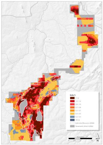
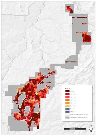
Figures 6 & 7: Kasiya March 2026 Model – Rutile (Rut94) Mineral Resource and Kasiya March 2026 Model – Graphite Mineral Resource
|
Enquiries |
|
Frank Eagar, Managing Director & CEO South Africa / Malawi +27 21 140 3190 Sapan Ghai, CCO London +44 207 478 3900 |
|
Nominated Adviser on AIM and Joint Broker |
|
|
SP Angel Corporate Finance LLP |
+44 20 3470 0470 |
|
Ewan Leggat Charlie Bouverat |
|
|
|
|
|
Joint Broker |
|
|
Stifel |
+44 20 7710 7600 |
|
Varun Talwar |
|
|
Ashton Clanfield |
|
Full data and statements here.
#URU URU Metals Ltd – COMMENCEMENT OF GROUND-BASED GEOPHYSICAL PROGRAMME
URU Metals Limited (“URU” or the “Company”) is pleased to announce that line preparation activities commenced on 2 March along the survey lines required for the planned ground-based geophysical programme at the Zeb Nickel Project (“Project”). The line preparation is necessary to provide safe and continuous access for survey crews and equipment, and to ensure accurate data acquisition along the planned gravity and frequency-domain electromagnetic profiles.
The line preparation marks the start of the next phase of exploration, aimed at enhancing the resolution and refining the interpretation of the previously completed airborne geophysical surveys.
Ground-Based Geophysical Programme
The ground-based geophysical survey will be conducted over two priority survey areas (as outlined in the map below) and will include:
· High-resolution gravity surveys
· Frequency-domain electromagnetic surveys
These surveys are being undertaken to improve the resolution and accuracy of the airborne EM, magnetic, and gravity datasets previously completed across the Project.
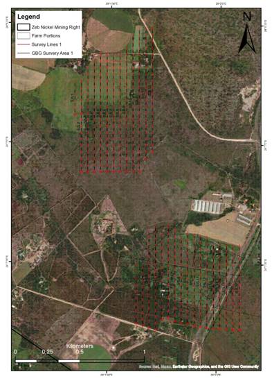
Figure 1: Maps showing the ground-based geophysical survey areas, with the first survey area in the bottom-right of the maps and the second survey area in the top-left. Line preparations along the survey lines commenced in the first survey area on 2 March.
Purpose and Benefits
While the airborne surveys successfully identified several coincident gravity-magnetic-electromagnetic anomalies and confirmed the presence of a magmatic conduit system, ground-based geophysics provides:
· Higher spatial resolution compared to airborne surveys
· Improved anomaly definition and depth constraints
· Enhanced discrimination between lithological contrasts and sulphide conductors
· Greater confidence in prioritising drill targets
In particular, the frequency-domain electromagnetic survey is designed to better delineate conductive bodies that may represent semi-massive to massive nickel sulphide mineralisation associated with the interpreted magmatic conduit system.
The higher-resolution gravity data will further assist in mapping dense ultramafic bodies and identifying potential sulphide accumulations within structural trap-sites.
Together, these surveys are expected to significantly refine drill targeting and reduce exploration risk ahead of the next drilling phase.
CEO John Zorbas commented:
“The commencement of ground-based geophysics represents an important technical step forward for the Zeb Nickel Project. While the airborne programme successfully identified several compelling targets, the higher-resolution ground surveys will allow us to sharpen our focus on the most prospective semi-massive nickel sulphide targets. This work is designed to maximise the effectiveness of our upcoming drilling campaign. We are very excited about the programme now underway and look forward to the coming weeks and months. We will provide shareholders with regular updates as line preparation progresses, the surveys advance, and results are interpreted.”
About the Company
URU Metals is a mineral exploration and development company focused on advancing high-potential critical metals projects in South Africa. The Company is committed to creating sustainable value through responsible mining practices, regulatory compliance, and active stakeholder engagement. For more information, visitwww.urumetals.com
For further information, please contact:
URU Metals Limited
John Zorbas
(Chief Executive Officer)
+1 416 504 3978
SP Angel Corporate Finance LLP
(Nominated Adviser and Broker)
Ewan Leggat / Caroline Rowe + 44 (0) 203 470 0470
#FDR First Development Resources PLC – Selta Project – Gold exploration update
First Development Resources plc (AIM: FDR), a UK-based, Australia-focused mineral exploration company with interests in Western Australia and the Northern Territory, is pleased to provide an update on its gold (“Au”) focused exploration at the Selta Project (“Selta” or the “Project”), located in the Aileron Province of Australia’s Northern Territory.
HIGHLIGHTS
· The high-resolution aeromagnetic (“AMAG”) and radiometric (“RAD”) geophysical survey over the Lander West regional gold target area has been successfully completed, covering approximately 4,200-line kilometres and delivering a high-quality geophysical survey dataset for targeting Au.
· Updated AMAG / RAD images are being interpreted, enhancing FDR’s understanding of subsurface geology, structures, and alteration patterns for drill targeting gold mineralisation associated with anomalous surface geochemical and historical shallow drilling results.
· These new airborne geophysical survey results will be integrated with ongoing Gradient Array Induced Polarisation (“GAIP”) survey results and historical geochemistry from surface sampling and shallow drilling to refine and prioritise target zone for future drilling.
· Planning and applications for land access and heritage approvals over target areas is currently underway.
Tristan Pottas, Chief Executive Officer of FDR, commented:
“Completion of the high-resolution AMAG and radiometric survey at Lander West represents a major step forward and it has materially improved our understanding of the subsurface geology and structural controls on mineralisation. We are grateful for the support received from Thomson Airborne, who delivered a high-quality, professional dataset on schedule over the holiday period.
The integration of the AMAG / RAD data with results from the ongoing GAIP survey and historical geochemical information will allow us to systematically refine and prioritise gold drill targets. We are very pleased with the quality of the datasets delivered and look forward to advancing Lander West through the next phase of exploration.”
AMAG / RAD SURVEY OUTCOMES
The completed AMAG / RAD survey was flown by Thomson Airborne Pty Ltd in early January 2026 using 100m spaced flight lines to generate high-resolution magnetic and radiometric datasets along approximately 4,200-line kilometres. The survey has delivered detailed imaging of structural features, lithological boundaries, and alteration signatures across the Lander West gold target area.
A comparison between the original regional airborne magnetic anomaly imagery and the new FDR acquired high-resolution AMAG imagery is provided in Figure 1 (original) and Figure 2 (newly acquired imagery). The new AMAG survey data have been processed to provide very detailed imagery on the subsurface geology and structure that will help FDR’s technical team to better constrain structures of interest for drill targeting Au mineralisation.
Figure 2 presents the First Vertical Derivative (“1VD”) of Total Magnetic Intensity reduced to magnetic pole (TMI RTP) filtered anomaly image. Additional data processing methods and three-dimensional (“3D”) inversion modelling results are being reviewed to identify areas of granitic intrusive contacts with meta-sediments and meta-volcanic host rocks, zones of folding and faulting, and hydrothermal alteration zones, which are key targeting criteria for potential gold mineralisation.
The newly acquired AMAG / RAD data results will be integrated with chargeability and resistivity information generated from the ongoing GAIP geophysics survey to better constrain and target potential mineralised zones at depth for follow up air-core (“AC”) drilling transects to test shallow targets and reverse circulation (“RC”) drilling to test deeper GAIP targets and drill under historical shallow Au anomaly zones. This combined geophysical interpretation, together with historical geochemical datasets, will underpin a robust, multi-disciplinary targeting framework to identify and prioritise drill-ready gold targets.
LANDER WEST GOLD TARGET
Following detailed desktop studies, FDR has identified the Lander West regional gold target area as a priority focus within the broader Selta Project. This target has been supported by a comprehensive gold targeting study completed by Resource Potentials Pty Ltd (“ResPot”), a Perth, Western Australia-based Mineral Exploration and Geophysical Consultancy. ResPot has been commissioned to integrate historical drilling, geological, geophysical, and geochemical datasets to help FDR define high-potential gold targets for follow-up work.
Lander West is interpreted as a continuation of the Stafford Gold Trend, where the adjacent ground hosts high-grade gold and antimony (“Sb”) mineralisation in the same geological units extending to the southeast (1). Gold mineralisation is believed to be shear-hosted, associated with zones of deformation and hydrothermal alteration, which produce subtle but measurable variations in magnetic response. Within Lander West, a very large granitic batholith, with smaller granite stocks along its margin, have been identified by the AMAG data to sit below thin sand cover sediments, and these granites are a likely source for the Au (and Sb) mineralising fluids to form Intrusive Related Gold (“IRG”) and skarn type gold targets with FDR’s land holding. High-resolution geophysical datasets are therefore critical to refining drill targets and advancing FDR’s gold exploration programme.
NEXT STEPS
Interpretation and 3D inversion modelling of the integrated AMAG / RAD, GAIP survey results and geochemical datasets is underway, and the result is already informing key areas for follow-up exploration planning, including the design and prioritisation of future AC and RC drilling programmes at Lander West. This systematic, data-driven approach is intended to maximise discovery potential while maintaining a disciplined and cost-effective exploration strategy over such a large gold target area.
Further updates will be provided as interpretation progresses and exploration activities advance.
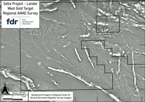
Figure 1: Original regional scale AMAG data anomaly image (1VD filtered and grey colour scale) from the Selta Project Lander West gold target area.
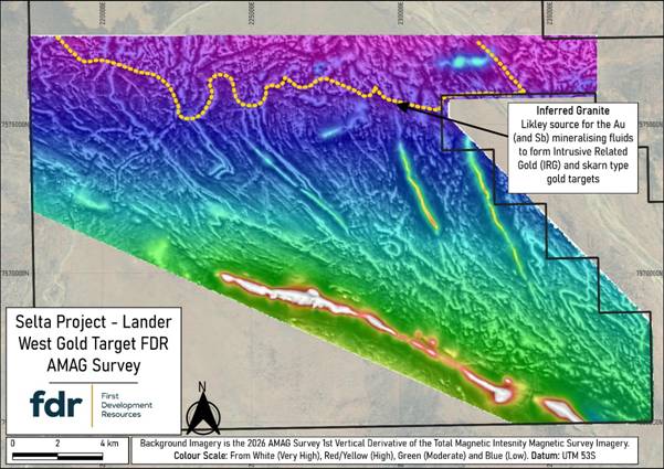
Figure 2: Newly-acquired first vertical derivate (1VD) on total magnetic intensity (TMI) filtered AMAG anomaly imagery from the Selta Project Lander West gold target area. This processing method helps sharpen shallow geological effects, such as fault systems, folds and shear zones, and it clearly identified a newly discovered granite contact in the north, which is a likely driver for hydrothermal fluids and heat to produce Au mineralisation.
REFERENCE
1. iTech Minerals Ltd (ASX: ITM) announcement dated 12 January 2026
(2924-03045120-2A1647835&v=undefined)
QUALIFIED PERSON STATEMENT
The technical information contained in this disclosure has been reviewed and approved by Mr Nicholas O’Reilly (MSc, DIC, MIMMM QMR, MAusIMM, FGS), who is a qualified geologist and acts as the Qualified Person under the AIM Rules – Note for Mining and Oil & Gas Companies. Mr O’Reilly is a principal consultant working for Mining Analyst Consulting Ltd which has been retained by First Development Resources plc to provide technical support.
GLOSSARY
|
Term |
Definition |
|
3D Inversion Modelling |
A technique that converts geophysical survey data into a three-dimensional (3D) map of underground structures, highlighting areas likely to host minerals. |
|
Aeromagnetic (AMAG) survey |
An airborne geophysical survey that measures variations in the Earth’s magnetic field to map subsurface geology and structures. |
|
Air-Core (AC) Drilling |
A drilling method for sampling shallow rocks efficiently, commonly used in early-stage exploration. |
|
Alteration patterns |
Recognisable changes in rocks caused by hot fluids moving through them, which can help indicate where valuable minerals may be concentrated. |
|
Chargeability information (GAIP Survey) |
Measures how strongly subsurface rocks hold an electric charge after introducing an electrical transmitter current into the ground, helping identify zones with disseminated sulphide minerals linked to gold. |
|
First Vertical Derivative (1VD) |
A magnetic data filter processing technique that calculates the rate of change of the magnetic field with height, enhancing short-wavelength anomalies and sharpening the edges of magnetic anomalies related to geological contacts, alteration zones, faults, and shear zones. |
|
Geochemical information |
Chemical data from rocks, soils, or fluids that is used to identify and understand areas with potential mineral deposits. |
|
Geophysical survey |
A method of measuring physical property changes in the Earth, such as magnetism, gravity, or electrical conductivity, to identify subsurface geological rock units, structures and potential mineral deposits. |
|
Gradient Array Induced Polarisation (GAIP) survey |
A geophysical survey method that maps anomalies caused by subsurface geology and mineralisation by measuring electrical properties of the ground. GAIP helps identify and prioritise prospective gold targets for follow-up exploration and drilling. |
|
Granitic Batholith |
A large underground granite body often associated with mineral deposits. |
|
High-resolution (AMAG Survey) |
Refers to geophysical data collected at closely spaced intervals (100m or less), providing detailed and precise information about subsurface magnetic features to improve target definition for exploration. |
|
Hydrothermal alteration |
Changes in rock caused by hot, mineral-rich fluids, often forming new minerals and altering the rock’s original composition. |
|
Intrusive Related Gold (IRG) |
Gold associated with igneous intrusions, commonly forming structurally controlled or disseminated deposits. |
|
Line Kilometre |
One kilometre of a geophysical survey line flown or surveyed. Total line kilometres indicate the survey’s overall coverage. |
|
Lithological boundary |
The contact or transition between different rock types, which can influence how fluids move and where minerals may accumulate. |
|
Metasediments |
Sediment-based rocks that have been metamorphosed, often forming targets for mineral exploration. |
|
Meta-volcanic host rocks |
Volcanic rocks altered by heat or pressure that host or control the formation of mineral deposits. |
|
Mineralisation |
The process by which valuable minerals are formed and concentrated in rocks, creating zones that may be mined for metals or other resources. |
|
Radiometric (RAD) survey |
Measures natural gamma radiation from rocks and regolith related to potassium (K), thorium (Th) and uranium (U) concentrations in the surface outcrop to highlight areas altered by minerals, helping pinpoint potential gold and other deposits. |
|
Resistivity information (GAIP Survey) |
Measures how strongly subsurface rocks resist electrical current, helping map geological rock units, structures, sulphide mineralisation and hydrothermal alteration zones |
|
Reverse-Circulation (RC) Drilling |
A standard exploration drilling approach that produces clean samples for assessing mineral deposits. |
|
Shear hosted |
Describes a rock or mineral deposit that occurs within, and is controlled by, a shear zone, where deformation created pathways for hydrothermal fluids and mineral deposition. |
|
Shear zone |
A zone of intense deformation where rocks have been sheared and fractured, often hosting gold due to the increased porosity formed along the shear zone. |
|
Skarn-Type Gold Targets |
Gold deposits formed where igneous intrusions alter carbonate rocks, creating mineral-rich zones. |
|
Stafford Gold Trend |
A regionally significant mineralised corridor in the Northern Territory, Australia, known for hosting gold and high-grade antimony deposits, which provides structural and geological continuity for exploration targets like Lander West. |
|
Structural feature |
A geological break or deformation in rocks such as faults, shear zones, or folds. |
|
Subsurface geology |
The type, structure, and arrangement of rocks below the Earth’s surface that help explain how mineral deposits may have formed. |
|
Total Magnetic Intensity (TMI) |
The measured strength of the Earth’s magnetic field at a location, including contributions from both the regional geomagnetic field and local magnetic variations caused by subsurface geology. |
|
Zone of deformation |
An area of rock altered or deformed by stress, such as faulting or folding. |
For further information visit www.firstdevelopmentresources.com or contact the following:
|
First Development Resources plc Tristan Pottas (CEO) |
Tel: +44 (0) 20 3778 1397 |
|
Beaumont Cornish Limited Nominated Adviser Roland Cornish / Asia Szusciak |
Tel: +44 (0) 20 7628 3396 |
|
SI Capital Limited Broker Nick Emerson |
Tel: +44 (0) 1483 413 500 |