
Home » Posts tagged 'Australia'
Tag Archives: Australia
#GRX GreenX Metals Limited – Notice of GM
 GreenX Metals Limited (GreenX or the Company) advises that its General Meeting (Meeting) will be held on Tuesday, 14 July 2026 at 10:00am (AWST) at the Conference Room, Ground Floor, 28 The Esplanade, Perth, Western Australia 6000.
In accordance with 110D of the Corporations Act 2001 (Cth), the Company will not be dispatching physical copies of the Notice of Meeting (unless a shareholder has elected to receive documents in hard copy in accordance with the timeframe specified in section 110E(8) of the Corporations Act 2001 (Cth)).
A copy of the Notice of Meeting can be viewed and downloaded online as follows:
|
· |
the Company’s website: https://greenxmetals.com/investors/announcements/. |
|
· |
the Company’s ASX Market announcements page at www.asx.com.au under the Company’s ASX code “GRX”; or |
|
· |
if you have provided an email address and have elected to receive electronic communications from the Company, you will receive an email to your nominated email address with a link to an electronic copy of the Notice of Meeting. |
The Company intends to hold a physical meeting. The Company will notify shareholders of any changes to this by way of an announcement and the details will also be made available on our website.
The Notice of Meeting is important and should be read in its entirety. If you are in doubt as to the course of action you should follow, you should consult your stock broker, investment advisor, accountant, solicitor or other professional adviser.
You may also, prior to the Meeting, obtain a paper copy of the Notice of Meeting (free of charge) by contacting the Company Secretary on +61 8 9322 6322 or by sending an email to info@greenxmetals.com.
Holders of Depositary Interests should complete and sign a separate Form of Instruction and return it by the time and in accordance with the instructions set out in the Form of Instruction. Holders on the Warsaw Stock Exchange should contact their brokers to submit their vote for the Meeting. Holders of Depositary Interests and holders on the Warsaw Stock Exchange will not be eligible to vote in person at the Meeting.
How do I update my communications preferences?
Shareholders can still elect to receive some or all of their communications in physical or electronic form or elect not to receive certain documents such as annual reports. To review your communications preferences, or sign up to receive your shareholder communications via email, please update your communication preferences with Computershare at http://www.investorcentre.com/au or contact your broker.
Enquiries:
|
GreenX Metals Limited |
Tel: +61 8 9322 6322 |
|
Dylan Browne, Company Secretary |
Email: info@greenxmetals.com |
#FDR First Development Resources PLC – Selta: Operational Preparations Ahead of Drilling
 First Development Resources plc (AIM: FDR), the UK-based, Australia-focused exploration company with mineral interests in the Northern Territory and Western Australia, is pleased to provide an update on preparations ahead of the commencement of the Company’s fully funded maiden Phase I Reverse Circulation (“RC”) drilling programme at the Lander West gold (“Au”) target, part of its 100%-owned Selta Project located in the Northern Territory, Australia.
The drilling programme is designed to test recently defined high-priority Au targets identified through the Company’s integrated geological, geophysical and geochemical interpretation programmes along the prospective Stafford Gold Trend.
HIGHLIGHTS
· Operational preparations advancing ahead of fully funded maiden Phase I RC drilling programme at the high-priority Lander West Au target planned for later this year
· Alice Springs-based Transport, Maintenance & Engineering Pty Ltd (“TMAE”) appointed as preferred earthworks contractor for access and drill pad establishment ahead of mobilisation
· Pre-mobilisation site visit commencing next week to review priority drill locations and finalise field logistics ahead of drilling
· All key regulatory approvals secured with mobilisation planning and drilling preparations continuing ahead of commencement later this year
Tristan Pottas, Chief Executive Officer of FDR, commented:
“The commencement of pre-mobilisation activities represents another important milestone as we advance towards maiden drilling at Lander West. Following the recent refinement of multiple high-priority drill targets, the Company is now transitioning from exploration planning into operational execution ahead of drilling.
“The recent completion of integrated geophysical interpretation has significantly enhanced our understanding of the mineralised structural architecture at Lander West and strengthened confidence in the upcoming maiden drilling programme. Importantly, the Company is fully funded to complete the Phase I RC drilling programme at Lander West.
“The appointment of TMAE provides the Company with an experienced Alice Springs-based contractor familiar with operating in remote Central Australian environments. Combined with the recent appointment of GeoDrill Australia as drilling contractor, we now have key operational partners in place as preparations continue to advance.
“The upcoming site visit will allow us to engage directly with stakeholders, review planned drill locations and finalise preparations ahead of mobilisation later this year. We look forward to providing further updates as activities continue to progress.”
PRE-MOBILISATION SITE VISIT
The pre-mobilisation site visit commencing next week forms part of the Company’s broader field planning and mobilisation programme ahead of commencement of drilling activities at Lander West.
The visit will focus on reconnaissance of existing access routes to the Lander West work area, inspection of proposed drillhole collar locations and review of planned infrastructure corridors ahead of mobilisation of the earthworks contractor. The programme is intended to ensure all field activities are appropriately planned and executed in accordance with approved environmental and operational management frameworks.
All earthworks associated with the drilling programme, including access preparation, drill pad establishment and associated infrastructure, will be undertaken in accordance with the conditions of the Company’s granted Environmental Mining Licence (“EML”) and certified Risk Management Plan (“RMP”).
During the visit, Company representatives will also engage with key stakeholders, including pastoral leaseholders, consultants and representatives of the Northern Territory Government, as preparations continue for commencement of drilling operations later in the year.
In addition, the Company expects to meet with representatives of GeoDrill Australia Pty Ltd (“GeoDrill”), recently appointed as drilling contractor for the Phase I RC drilling programme at Lander West. GeoDrill is currently undertaking drilling activities along the Stafford Gold Trend on neighbouring ground, providing an opportunity to coordinate mobilisation planning and operational activities ahead of commencement of drilling.
APPOINTMENT OF EARTHWORKS CONTRACTOR
The Company is also pleased to announce the appointment of Transport, Maintenance & Engineering Pty Ltd (“TMAE”) as preferred earthworks contractor for the establishment of access and drilling infrastructure at Lander West.
TMAE is an Alice Springs, Northern Territory-based contractor providing heavy equipment maintenance, earthmoving support, mobile mechanical services and remote field operations support across Central Australia. The company has extensive experience operating in remote and logistically challenging environments and supports a range of mining, civil construction, transport and earthmoving operations throughout the Northern Territory.
The Company selected TMAE based on its regional operational capability, local knowledge, remote-area logistics experience and ability to provide responsive field support during exploration activities in Central Australia. The appointment of an experienced locally based contractor is expected to support efficient and cost-effective programme execution during site establishment and drilling preparation activities.
Representatives from FDR and TMAE are expected to meet during the site visit to finalise preparations for establishment of approved access tracks, drill pads and associated infrastructure ahead of drilling mobilisation.
The Company expects to provide further updates as site preparation activities progress towards commencement of drilling operations later this year.
For further information visit www.firstdevelopmentresources.com or contact the following:
|
First Development Resources plc Tristan Pottas (CEO) |
Tel: +44 (0) 7790 589 364 |
ABOUT REACH ANNOUNCEMENTS
This is a Reach announcement. Reach is an investor communication service aimed at assisting listed and unlisted (including AIM quoted) companies to distribute media only / non-regulatory news releases into the public domain. Information required to be notified under the AIM Rules for Companies, Market Abuse Regulation or other regulation would be disseminated as an RNS regulatory announcement and not on Reach.
ABOUT FIRST DEVELOPMENT RESOURCES
First Development Resources’ assets comprise eight granted tenements covering a total area of 2,314.4km2. Five of the tenements, comprising three prospective copper-gold projects, are located in Western Australia (WA) while the remaining three tenements, comprising a rare-earth element (REE), uranium, lithium and gold project, are located in the Australian’s Northern Territory. All tenements are wholly owned by FDR. The assets are a mixture of drill ready and earlier stage exploration.
The WA Projects include the Company’s Wallal Project as well as Ripon Hills and Braeside West Projects situated in the Paterson Province, which is widely regarded as one of the most productive regions in Australia for the discovery of world-class gold-copper deposits, and which is home to several world-class mines and more recent discoveries.
The Selta Project in the Northern Territory is located in an area considered highly prospective for uranium and rare-earth element mineralisation along with base and precious metal mineralisation. Numerous companies are actively exploring within the region.
Beyond the existing portfolio, FDR is actively looking to expand its portfolio through the acquisition of early-stage exploration projects in Australia.
SELTA PROJECT INDICATIVE OPERATIONAL TIMELINE

Indicative operational milestones for exploration activities at the Selta Project. Schedule subject to change.
#FDR First Development Resources PLC – Selta Update: Appointment of Drilling Contractor
 First Development Resources plc (AIM: FDR), the UK-based, Australia-focused exploration company with mineral interests in the Northern Territory and Western Australia, is pleased to announce the appointment of GD GeoDrill Australia Pty Ltd (“GeoDrill Australia”) as drilling contractor for the Company’s maiden Phase I Reverse Circulation (“RC”) drilling programme at the Lander West gold target within its 100%-owned Selta Project in the Northern Territory, Australia.
The appointment of GeoDrill Australia represents a significant operational milestone for the Company and follows completion of the necessary regulatory approvals required to commence drilling activities at Lander West.
GeoDrill Australia was selected as the preferred drilling partner based on its strong technical capabilities, modern equipment fleet and proven track record of safe and efficient programme delivery across Australia and within the Selta region.
GEODRILL AUSTRALIA – TECHNICAL & ENVIRONMENTAL, HEALTH & SAFETY (“EH&S”) CAPABILITY
· Extensive experience delivering RC and mineral exploration drilling programmes, including multi-rig, continuous operations across Australia
· Modern high-performance drilling fleet designed to maximise productivity, sample quality and operational efficiency
· Experienced crews with a strong track record operating safely in remote and logistically challenging environments
· Management systems aligned to internationally recognised standards, including ISO 45001 (Occupational Health and Safety), ISO 9001 (Quality Management) and ISO 14001 (Environmental Management)
· A proactive safety-first culture underpinned by continuous risk assessment, rigorous operational procedure and strict environmental compliance
This combination of technical delivery capability and high EH&S standards aligns closely with FDR’s commitment to safe, responsible and efficient exploration.
RISK MANAGEMENT & REGULATORY APPROVAL PROCESS
In preparation for the Phase I RC drilling programme at Lander West, the Company updated its Risk Management Plan (“RMP”) and Emergency Response Plan (“ERP”) to incorporate the operational requirements associated with RC drilling activities.
The updated documentation underwent independent technical review and has now been formally assessed and certified by NT WorkSafe.
Accordingly, the Company has received all necessary regulatory approvals required to commence the planned Phase I RC drilling programme at Lander West.
Certification of the RMP authorises the Company to commence drilling activities under an approved risk management framework and marks completion of the principal regulatory approvals required for the programme.
Tristan Pottas, Chief Executive Officer of FDR, commented:
“We are pleased to have appointed GeoDrill Australia as our drilling partner for the maiden RC drilling programme at Lander West. Their combination of technical expertise, modern equipment and strong safety culture gives us confidence in the efficient execution of the programme.
With the appointment of GeoDrill Australia and all key regulatory approvals now secured, the Company can focus on the final operational and logistical preparations ahead of mobilisation. We look forward to commencing drilling and delivering results to shareholders in the near term.”
LANDER WEST PHASE I RC DRILLING PROGRAMME
The Phase I RC drilling programme at Lander West has been designed as a targeted first-pass test of priority structural and geochemical targets identified through integrated geological and geophysical interpretation.
The programme forms part of a staged Phase I RC campaign of up to 3,000 metres, comprising an initial priority drilling phase followed by a flexible follow-up phase subject to field observations and results.
Drill targeting has been refined using recently completed aeromagnetic (“AMAG”), radiometric (“RAD”) and Gradient Array Induced Polarisation (“GAIP”) surveys, integrated with geochemical and historical drilling datasets.
The programme is designed to test:
· Major shear zones and fault intersections
· Magnetic anomalies interpreted as intrusive bodies and structural controls
· Coincident chargeability and magnetic anomalies associated with potential hydrothermal alteration
· Anomalous Au and arsenic (“As”) geochemistry from previous drilling and surface sampling
· Targets beneath shallow sediment cover extending to bedrock
Lander West lies within the broader Stafford Gold Trend, a recognised mineralised corridor hosting Au and antimony (“Sb”) mineralisation on neighbouring tenements. Recent drilling on nearby ground operated by iTech Minerals Ltd has reinforced the prospectivity of the regional mineralised system and supports the Company’s targeting rationale at Lander West.
The programme represents an important step in advancing the Lander West Gold Target and testing the scale and mineralisation potential of the broader system.
For further information visit www.firstdevelopmentresources.com or contact the following:
|
First Development Resources plc Tristan Pottas (CEO) |
Tel: +44 (0) 7790 589 364 |
|
Beaumont Cornish Limited Nominated Adviser Roland Cornish / Asia Szusciak |
Tel: +44 (0) 20 7628 3396 |
|
SI Capital Limited Broker Nick Emerson
|
Tel: +44 (0) 1483 413 500 |
#FDR First Development Resources PLC – Selta: Geophysical Interpretation & Drill Planning
First Development Resources plc (AIM: FDR), the UK-based, Australia-focused mineral exploration company with interests in the Northern Territory and Western Australia, is pleased to announce preliminary results from recently completed geophysical surveys at the Lander West gold (“Au”) target, part of the Company’s 100%-owned Selta Project located in the Northern Territory, Australia.
The geophysical surveys comprised high-resolution airborne magnetics (“AMAG”), radiometrics (“RAD”) and ground-based Gradient Array Induced Polarisation (“GAIP”). These datasets have been integrated with geological, geochemical and historical drilling data to refine the Company’s understanding of the project area and support the design of a maiden Reverse Circulation (“RC”) drilling programme.
The planned drilling is designed to test structurally controlled and intrusion-related Au mineralisation associated with the regionally significant Stafford Gold Trend.
HIGHLIGHTS
· Integrated geological, geophysical and geochemical interpretation has significantly refined the structural and lithological model for Au targeting at Lander West.
· Key geological features identified include granitic contacts beneath thin sand cover, interpreted buried intrusions, major shear zones, faults and fold structures-features known to host significant Au mineralisation both in Australia and globally.
· Phase I RC drilling programme of up to ~3,000 metres, to be executed in two sub-phases comprising an initial c.2,000 metre programme targeting approximately 10 priority drillholes, followed by a flexible c.1,000 metre follow-up phase subject to field observations and results.
Tristan Pottas, Chief Executive Officer of FDR, commented:
“The completion of this integrated geophysical survey programme represents a significant step forward in defining high-quality drill targets for Au at Lander West. By combining new high-resolution magnetic, radiometric and IP datasets with existing geological and geochemical information, we have materially improved our understanding of the structural architecture controlling mineralisation.
Importantly, the recent survey work has identified a compelling combination of shear-related and intrusion-related Au targets, including a large interpreted buried granite body that may have acted as a heat and fluid source driving mineralisation.
The presence of multiple high-priority targets associated with major structures within the Stafford Gold Trend provides strong confidence as we advance to our maiden RC drilling programme. We now look forward to drill testing these targets and unlocking the project’s potential.”
INTEGRATED INTERPRETATION AND TARGETING
Following completion of the GAIP survey, FDR’s Perth-based consultants, Resource Potentials Pty Ltd (“ResPot”), undertook an integrated review of all available datasets, including AMAG, RAD, GAIP, geochemistry and historical drilling.
This work has significantly improved the definition of the geological architecture at Lander West (Figure 1), which is largely concealed beneath shallow sedimentary cover. Interpretation is ongoing to identify additional Au targets.
Key interpreted features include:
· Contacts between prospective granite bodies and surrounding metasedimentary and volcanic host rocks,
· Buried granitic intrusions, plugs and porphyry dyke systems,
· Major shear zones and fault structures,
· Fold axes, dipping limbs and structural corridors, and
· Younger mafic dyke intrusions post-dating the Au mineralising event.
The mineralised corridors are interpreted to lie between two large granite batholiths, likely acting as heat sources driving hydrothermal fluid flow and forming shear-hosted Au systems. Historical shallow drilling suggests a stronger association with the northern batholith, while structural control is evident in the southern target area.
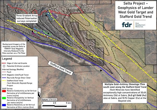
Figure 1:Interpreted large-scale structural controls on the Lander West gold targets. Interpretation of these structures has been further refined following the recent completion of AMAG / RAD and GAIP geophysical surveys by FDR.
INTRUSION-RELATED GOLD SYSTEM TARGETING
Geophysical interpretation has identified a large intrusion-related target zone in the northern licence area. This is interpreted as a buried granitic batholith beneath thin sedimentary cover, previously unmapped and unexplored for Au and other minerals such as copper (“Cu”) and lithium (“Li”), despite anomalous geochemistry in historical shallow drilling.
This interpretation is supported by:
· Magnetic and radiometric responses consistent with felsic intrusive rocks, interpreted as late-stage and comparable in age to “fertile” granites in the region,
· A coincident regional gravity low, and
· Supporting topographic signatures from digital elevation and geological datasets.
These features are consistent with a late granite intrusion potentially associated with Au, antimony (“Sb”), Li and rare-earth elements (“REE”).
Additional smaller felsic porphyry stocks and dykes have also been identified. Where felsic intrusive rocks are intersected during drilling, selective sampling may be undertaken to support potential age-dating and further geological analysis.
ROLE OF THE GAIP SURVEY
The GAIP survey has provided key subsurface information on conductivity and chargeability, aiding identification of structures and potential sulphide mineralisation associated with Au deposition.
It has been particularly effective in confirming:
· Shear zones,
· Lithological boundaries, and
· Structural corridors
These are critical target zones for both shear-hosted and intrusion-related Au systems.
Drilling results will be used to calibrate GAIP responses against mineralisation, improving its effectiveness as a targeting tool.
PHASE I RC DRILL PROGRAMME DESIGN
A maiden Phase I RC drilling programme has been designed as a staged programme of up to ~3,000 metres, comprising an initial priority sub-phase followed by a flexible follow-up phase.
The programme is expected to commence with an initial sub-phase targeting approximately 10 high-priority drillholes (c.2,000 metres). These holes have been selected based on integrated geological, geophysical and geochemical datasets and are designed to test the most prospective structural and intrusion-related Au targets.
A second, follow-up sub-phase of up to c.1,000 metres has been provisionally planned, comprising additional drillholes that will be refined and prioritised based on observations and results from the initial drilling. These follow-up holes are therefore considered flexible and subject to change as new data is acquired during the programme.
In total, the current drill plan comprises up to 16 holes for approximately 3,000 metres; however, the final number, positioning and depth of drillholes will remain adaptable as the programme progresses.
Targets include:
· Major structural zones (shears, faults, fold “jogs”) coincident with geochemical anomalies,
· Edges of magnetic anomalies interpreted as intrusive bodies in contact with host rocks (including skarn and intrusion-related targets), and the structural controls related to them,
· Coincident GAIP chargeability and magnetic anomaly zones interpreted to be caused by hydrothermal alteration associated with both shear and intrusion-related Au targets, and
· Anomalous Au and arsenic (“As”) results from previous shallow drilling.
Drill collar locations have been optimised using integrated datasets (Figure 2), with flexibility retained to refine targets as results from the initial sub-phase are received.
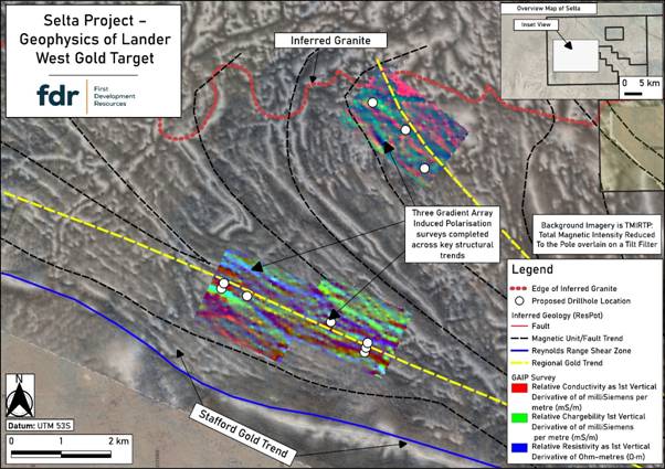
Figure 2: Lander West Phase I RC drill hole locations (white dots), which have been optimised following integration of AMAG / RAD and GAIP geophysical survey results.
CONTEXT WITHIN THE STAFFORD GOLD TREND
Lander West lies within the Stafford Gold Trend, a regionally significant structural corridor known for hosting Au and Sb mineralisation, as well as recently discovered high-grade Li pegmatites.
Exploration 15-20 km to the southeast has reported results of up to 30.6% Sb and 24 g/t Au.
The Company is targeting:
· Shear-hosted Au mineralisation within the Stafford Gold Trend, and
· Intrusion-related Au systems associated with felsic intrusions to the north.
The combination of a large interpreted late granite intrusive system and well-developed structural controls significantly enhance prospectivity and supports the Company’s maiden drill campaign.
NEXT STEPS
· Final planning and drilling contractor engagement,
· Earthworks clearing of approved access routes and drill pads,
· Mobilisation and commencement of the Phase I RC drilling programme, targeted for mid-year, with all necessary approvals now secured, including the Environmental (Mining) Licence and the Northern Territory Government’s Notice of Authority to Commence, and
· Ongoing geological and geophysical interpretation and refinement of targets during drilling.
The Company looks forward to commencing its maiden RC drilling programme at Lander West and will update shareholders as preparations are finalised and the drilling commences.
Qualified Person Statement
The technical information contained in this disclosure has been reviewed and approved by Mr Nicholas O’Reilly (MSc, DIC, MIMMM QMR, MAusIMM, FGS), who is a qualified geologist and acts as the Qualified Person under the AIM Rules – Note for Mining and Oil & Gas Companies. Mr O’Reilly is a principal consultant working for Mining Analyst Consulting Ltd which has been retained by First Development Resources plc to provide technical support.
GLOSSARY
|
Term |
Definition |
|
AMAG (Airborne Magnetics) |
A geophysical survey method that measures variations in the Earth’s magnetic field from the air to map subsurface geological structures. |
|
Arsenic (As) |
A chemical element commonly associated with Au mineralisation and used as a pathfinder in geochemical exploration. |
|
Batholith |
A large, deep-seated body of intrusive igneous rock, typically granitic in composition. |
|
Chargeability |
A measure of a material’s ability to temporarily hold an electrical charge, often used to detect sulphide mineralisation in IP surveys. |
|
Conductivity |
The ability of a material to conduct electrical current, used in geophysics to identify different rock types and alteration zones. |
|
Copper (Cu) |
A base metal often associated with hydrothermal systems and sometimes co-located with Au mineralisation. |
|
Dyke |
A sheet-like body of igneous rock that cuts across existing rock layers. |
|
Felsic |
A term describing silica-rich igneous rocks, typically light-coloured and commonly associated with granitic compositions. |
|
Fold |
A bend or curvature in rock layers caused by tectonic forces. |
|
GAIP (Gradient Array Induced Polarisation) |
A ground-based geophysical method that measures chargeability and resistivity to identify subsurface structures and sulphide mineralisation. |
|
Geochemistry |
The study of the chemical composition of rocks, soils and sediments to identify anomalous element concentrations. |
|
Geophysics |
The application of physical measurement techniques to investigate subsurface geological features. |
|
Granite |
A coarse-grained felsic intrusive igneous rock commonly associated with mineralising systems. |
|
Hydrothermal |
Relating to hot fluids circulating within the Earth’s crust that can transport and deposit minerals. |
|
Intrusion (Intrusive Body) |
A body of igneous rock formed when magma solidifies beneath the Earth’s surface. |
|
Intrusion-Related Gold System |
A type of mineral system where Au mineralisation is genetically linked to felsic intrusive rocks. |
|
Lithology |
The physical characteristics and composition of a rock unit. |
|
Lithological Boundary |
The contact between two different rock types. |
|
Lithium (Li) |
A light metal commonly found in pegmatites and increasingly important for battery technologies. |
|
Magnetic Anomaly |
A local variation in the Earth’s magnetic field caused by differences in the magnetic properties of subsurface rocks. |
|
Mafic |
Describes igneous rocks rich in magnesium and iron, typically darker in colour. |
|
Metasediments |
Sedimentary rocks that have been altered by heat and pressure without melting. |
|
Mineralisation |
The process by which economically valuable minerals are introduced into a rock. |
|
Pegmatite |
A very coarse-grained igneous rock often enriched in rare elements such as Li and REE. |
|
Porphyry |
An igneous rock with large crystals set in a finer-grained groundmass, often associated with mineral deposits. |
|
Radiometrics (RAD) |
A geophysical method that measures natural gamma radiation to identify variations in surface and near-surface geology. |
|
Rare Earth Elements (REE) |
A group of chemically similar elements used in high-technology applications and often found in specialised mineral deposits. |
|
RC (Reverse Circulation) Drilling |
A drilling technique that uses compressed air to return rock chips to the surface for sampling. |
|
Resistivity |
A measure of how strongly a material resists electrical current, used to differentiate rock types and structures. |
|
Shear Zone |
A zone of intense deformation where rocks have been displaced along a planar structure. |
|
Shear-Hosted Gold System |
A type of Au deposit controlled by deformation zones such as faults and shear zones. |
|
Skarn |
A calc-silicate rock formed by metasomatic alteration, often associated with mineralisation near intrusions. |
|
Structural Corridor |
A zone of aligned geological structures that can control the movement of mineralising fluids. |
|
Structure (Geological) |
Any feature in rocks formed by deformation, such as faults, folds or shear zones. |
|
Sulphide Mineralisation |
The occurrence of sulphide minerals, often associated with metal deposits including Au. |
|
Target (Exploration Target) |
A geological area identified as having potential to host mineralisation based on available data. |
|
Uranium (U) |
A radioactive element used as a fuel source and often explored for in sedimentary and igneous environments. |
For further information visit www.firstdevelopmentresources.com or contact the following:
|
First Development Resources plc Tristan Pottas (CEO) |
Tel: +44 (0) 20 3778 1397 |
|
Beaumont Cornish Limited Nominated Adviser Roland Cornish / Asia Szusciak |
Tel: +44 (0) 20 7628 3396 |
|
SI Capital Limited Broker Nick Emerson
|
Tel: +44 (0) 1483 413 500 |
#FDR First Development Resources PLC – Update on Selta Project
First Development Resources plc (AIM: FDR), the UK-based, Australia-focused exploration company, is pleased to announce that it has received formal Notice of Authority to Commence Mining Activities at the Lander West gold target, part of its 100%-owned Selta Project in the Northern Territory, Australia.
The notice has been issued by the Northern Territory Government following the Company’s successful application for an Environmental (Mining) Licence (“EML”) (Exploration Licence No: EL32755), and the lodgement and acceptance of the required security bond.
This approval represents a key regulatory milestone and enables the Company to proceed with the commencement of mining activities, specifically Reverse Circulation (“RC”) drilling at the Lander West gold Target in accordance with the approved environmental and operational conditions.
With all necessary approvals now secured, FDR can proceed with drilling at Lander West – a critical step in advancing the Selta Project and unlocking its gold potential. The commencement of drilling will mark the Company’s first material move into active exploration on the ground at Selta, with results expected to drive news flow and project momentum.
The Company will provide further updates as pre-mobilisation and operational activities progress.
HIGHLIGHTS
· Notice of Authority to Commence Mining Activities received (dated April 21st 2026) from the Northern Territory Government Department of Mining and Energy
· Environmental (Mining) Licence security bond lodged and accepted in full clears pathway for Phase I RC Drilling Programme at Lander West gold Target
· Preparations for Phase I RC Drilling Programme underway
Tristan Pottas, Chief Executive Officer of FDR, commented:
“Receiving the formal Notice to Commence Mining at Lander West marks a significant step forward for the Company as we transition from target generation into drilling operations.
With all key regulatory approvals now in place, including the grant of our Environmental (Mining) Licence and acceptance of the security bond, we are focused on progressing towards commencing the Phase I RC Drilling Programme in the near term.
Lander West represents an important opportunity within our 100%-owned Selta Project, and we look forward to updating shareholders as we move into the next phase of development.”
For further information visit www.firstdevelopmentresources.com or contact the following:
|
First Development Resources plc Tristan Pottas (CEO) |
Tel: +44 (0) 20 3778 1397 |
ABOUT REACH ANNOUNCEMENTS
This is a Reach announcement. Reach is an investor communication service aimed at assisting listed and unlisted (including AIM quoted) companies to distribute media only / non-regulatory news releases into the public domain. Information required to be notified under the AIM Rules for Companies, Market Abuse Regulation or other regulation would be disseminated as an RNS regulatory announcement and not on Reach.
ABOUT FIRST DEVELOPMENT RESOURCES
First Development Resources’ assets comprise eight granted tenements covering a total area of 2,314.4km2. Five of the tenements, comprising three prospective copper-gold projects, are located in Western Australia (WA) while the remaining three tenements, comprising a rare-earth element (REE), uranium, lithium and gold project, are located in the Australia’s Northern Territory. All tenements are wholly owned by FDR. The assets are a mixture of drill ready and earlier stage exploration.
The WA Projects include the Company’s Wallal Project as well as Ripon Hills and Braeside West Projects situated in the Paterson Province, which is widely regarded as one of the most productive regions in Australia for the discovery of world-class gold-copper deposits, and which is home to several world-class mines and more recent discoveries.
The Selta Project in the Northern Territory is located in an area considered highly prospective for uranium and rare-earth element mineralisation along with base and precious metal mineralisation. Numerous companies are actively exploring within the region.
Beyond the existing portfolio, FDR is actively looking to expand its portfolio through the acquisition of early-stage exploration projects in Australia.
SELTA PROJECT INDICATIVE OPERATIONAL TIMELINE

Indicative operational milestones for exploration activities at the Selta Project. Schedule subject to change.
#FDR First Development Resources PLC – Selta – Environmental (Mining) Licence Granted
First Development Resources plc (AIM: FDR), the UK-based, Australia-focused exploration company with mineral interests in the Northern Territory and Western Australia, is pleased to announce that it has been granted an Environmental (Mining) Licence (“EML”) by the Northern Territory Government Department of Lands, Planning and Environment (“DLPE”).
The grant of the EML is a significant operational milestone, enabling FDR to transition from surface exploration to drilling at the high-priority Lander West Gold Target, located within the Stafford Gold Trend at the Company’s wholly owned Selta Project in Australia’s Northern Territory.
Tristan Pottas, Chief Executive Officer of FDR, commented:
“Securing the Environmental (Mining) Licence is a pivotal achievement for the Company and allows us to move immediately from target generation to drill testing at Lander West.
Following a disciplined and methodical exploration programme, we have developed a strong pipeline of priority drill targets. We are now focused on executing an RC drilling campaign later this year to test these compelling gold opportunities along the Stafford Gold Trend, where ongoing exploration by other operators continues to deliver encouraging results.
We believe this next phase has the potential to deliver significant value for shareholders.”
ENVIRONMENTAL (MINING) LICENCE APPROVAL
The grant of the EML allows the Company to undertake on-ground exploration activities under an approved DLPE Mining Management Plan and marks a clear pathway to drilling.
FDR is now advancing plans for a targeted reverse circulation (“RC”) drilling programme at the highly prospective Lander West Gold Target, with planning and preparatory work already underway.
The approved mining activities under FDR’s EML include:
· 40 RC drill holes, drill pads and sumps
· Tracks of a maximum 3m width, totalling 13.5km
· Total surface disturbance of 6.45 hectares
ADVANCING TO DRILLING PHASE
FDR has completed multiple phases of systematic exploration across Lander West, including:
· In-depth desktop geological studies
· Aeromagnetic and radiometric surveys
· Gradient Array Induced Polarisation (“GAIP”) survey
The integration of these datasets has refined the Company’s geological model and strengthened its understanding of structural controls on mineralisation, resulting in the definition of several priority drill targets along the prospective Stafford Gold Trend.
RC drilling represents the most decisive stage of this exploration strategy, providing direct testing for gold mineralisation.
NEXT STEPS
FDR is progressing operational planning, contractor engagement and site logistics in preparation for the planned RC drilling programme.
Following payment of the environmental security bond, the Company expects to receive formal notice to commence activities from the Northern Territory Government within approximately five business days.
Drilling is targeted to begin later this year, with the programme designed to test the most prospective zones at Lander West and deliver the first subsurface data from these targets.
Further updates will be provided as preparations advance and drilling activities commence.
For further information visit www.firstdevelopmentresources.com or contact the following:
|
First Development Resources plc Tristan Pottas (CEO) |
Tel: +44 (0) 20 3778 1397 |
|
Beaumont Cornish Limited Nominated Adviser Roland Cornish / Asia Szusciak |
Tel: +44 (0) 20 7628 3396 |
|
SI Capital Limited Broker Nick Emerson
|
Tel: +44 (0) 1483 413 500 |
Beaumont Cornish Limited (“Beaumont Cornish”) is the Company’s Nominated Adviser and is authorised and regulated by the FCA. Beaumont Cornish’s responsibilities as the Company’s Nominated Adviser, including a responsibility to advise and guide the Company on its responsibilities under the AIM Rules for Companies and AIM Rules for Nominated Advisers, are owed solely to the London Stock Exchange. Beaumont Cornish is not acting for and will not be responsible to any other persons for providing protections afforded to customers of Beaumont Cornish nor for advising them in relation to the proposed arrangements described in this announcement or any matter referred to in it.
ABOUT FIRST DEVELOPMENT RESOURCES
First Development Resources’ assets comprise eight granted tenements covering a total area of 2,314.4km2. Five of the tenements, comprising three prospective copper-gold projects, are located in Western Australia (WA) while the remaining three tenements, comprising a rare-earth element (REE), uranium, lithium and gold project, are located in the Australian’s Northern Territory. All tenements are wholly owned by FDR. The assets are a mixture of drill ready and earlier stage exploration.
The WA Projects include the Company’s Wallal Project as well as Ripon Hills and Braeside West Projects situated in the Paterson Province, which is widely regarded as one of the most productive regions in Australia for the discovery of world-class gold-copper deposits, and which is home to several world-class mines and more recent discoveries.
The Selta Project in the Northern Territory is located in an area considered highly prospective for uranium and rare-earth element mineralisation along with base and precious metal mineralisation. Numerous companies are actively exploring within the region.
Beyond the existing portfolio, FDR is actively looking to expand its portfolio through the acquisition of early-stage exploration projects in Australia.
SELTA PROJECT INDICATIVE OPERATIONAL TIMELINE

Indicative operational milestones for exploration activities at the Selta Project. Schedule subject to change.
#FDR First Development Resources PLC – Operational Update – Selta Project
First Development Resources plc (AIM: FDR), the UK-based, Australia-focused exploration company with mineral interests in Western Australia and the Northern Territory, is pleased to provide an operational update for its Selta Project (“Selta” or the “Project”) located in the Aileron Province of Australia’s Northern Territory.
HIGHLIGHTS
· Lander West Gold Target – GAIP Survey – GAIP geophysical survey at the Lander West gold target approximately 50% complete, with fieldwork expected to resume in early April following weather-related suspension in Central Australia.
· Data-Driven Drill Targeting – Integrated interpretation of GAIP, aeromagnetic, radiometric, and geochemical data is underway. Early results are already guiding design and prioritisation of future air core drilling and reverse circulation drilling programmes at Lander West.
· Permitting and Government Support – Environmental (Mining) Permit applied for in February 2026, with determination expected in Q2 2026. Co-funding from the Northern Territory Government’s Resourcing the Territory ‘Geophysics and Drilling Collaborations’ (“GDC”) programme is being pursued to offset exploration costs.
· Lithium and Rare-Earth Exploration – UAV magnetic geophysics survey scheduled for May 2026 over Hawkshead lithium-REE target to identify pegmatite structures. REE exploration at West Nintabrinna and Ingallan continues, with fieldwork planned for Q3 2026.
Tristan Pottas, Chief Executive Officer of FDR, commented:
“We are advancing the Selta Project with real momentum. The GAIP survey at Lander West will recommence soon, and the integrated analysis of our geophysical and geochemical data is already sharpening our drill targets. With an Environmental (Mining) Permit application underway, government co-funding support being pursued, and new lithium and rare-earth opportunities being actively explored, we are positioned to unlock multiple high-potential mineral targets across Selta.
Our disciplined, data-driven approach ensures we maximise discovery potential while delivering cost-effective, results-focused exploration.”
LANDER WEST GOLD TARGET – GRADIENT ARRAY INDUCED POLARISATION (“GAIP”) SURVEY
The GAIP geophysical survey at the Lander West gold target commenced in early January 2026 and is designed to complement the previously completed high-resolution aeromagnetic and radiometric geophysical surveys. The GAIP programme aims to enhance the Company’s understanding of subsurface geology and structural architecture across the target area, supporting the refinement of potential drill targets. Adverse weather conditions across large parts of Central Australia resulted in a temporary break in the GAIP survey. As a safety precaution in early February the decision was taken to pause the survey and remove the team from site. Flooding throughout the region made access tracks impassable particularly at creek crossings.
The Company’s geophysical contractor, Zonge Engineering and Research Organisation (Aust) Pty Ltd, returned to site on Friday 13 March to assess ground conditions and plan for the resumption of field operations. While weather conditions have improved, access to site remains challenging.
Subject to access conditions continuing to improve, the team expects to remobilise in early April. Approximately 50% of the survey remains to be completed and is expected to take around two to three weeks.
DRILL TARGET REFINEMENT
The results from the GAIP survey will be integrated with the geophysical results from the Aeromagnetic survey (“AMAG”) and radiometric (“RAD”) survey competed across the Lander West gold target in early 2026. Interpretation and three-dimensional inversion modelling of the integrated AMAG / RAD, GAIP survey results and geochemical datasets is underway, and this information is already informing key areas for follow-up exploration planning, including the design and prioritisation of future air core (“AC”) and reverse circulation (“RC”) drilling programmes at Lander West. This systematic, data-driven approach is intended to maximise discovery potential while maintaining a disciplined and cost-effective exploration strategy over such a large gold target area.
ENVIRONMENTAL (MINING) PERMIT APPLICATION
An Environmental (Mining) Permit (“EMP”) in the Northern Territory, Australia, is a regulatory approval that enables a company to undertake ground disturbing mineral exploration or mining activities in compliance with environmental management requirements. Issued under the Mining Management Act 2001 and administered by the Northern Territory Department of Mining and Energy, the permit requires companies to submit and maintain an approved Mining Management Plan outlining proposed activities, environmental impact mitigation measures, and site rehabilitation commitments. Mineral exploration companies must obtain this approval before commencing on-ground activities to ensure operations are conducted in a manner that minimises environmental disturbance and protects land, water, ecosystems, and cultural heritage within the Northern Territory. FDR applied for an EMP in February 2026, the application included proposed drill locations and access tracks at the Lander West gold target. The Company expects to receive determination of its application in Q2 2026.
DRILLING CONTRACTOR SELECTION
The Company has approached drilling contractors to provide quotations for the proposed Lander West gold drilling programme. Proposals are being reviewed by the Company.
NORTHERN TERRITORY GOVERNMENT GRANT PROGRAMMES
To support the planned drilling programme at Lander West, the Company is preparing an application to seek co-funding from the Northern Territory Government as part of the Resourcing the Territory ‘Geophysics and Drilling Collaborations’ grant programme. The programme is a Northern Territory Government initiative that provides co-funding to support mineral exploration drilling and geophysical programmes across the Northern Territory. Delivered through the Northern Territory Geological Survey under the broader Resourcing the Territory Programme, the programme typically funds up to 50% of eligible drilling and geophysical survey costs, helping reduce the financial risk of early-stage exploration and encouraging companies to test new mineral targets. 1
HAWKSHEAD LITHIUM TARGET
The Hawkshead lithium-caesium-tantalum (“LCT”) and rare earth element (“REE”) target was identified following a desktop study undertaken by the Company, which built upon previous exploration activities and incorporated additional open-file geological data. The study generated several prospective targets across the project area, including Hawkshead, which are referenced in the Competent Person’s Report forming part of the Company’s Admission Document.
The Company has engaged Pegasus Airborne Systems Pty Ltd to complete an unmanned airborne vehicle (“UAV”) magnetic (“UAV-Mag”) survey over the Hawkshead lithium-REE target within its tenements in the Northern Territory. The survey, which is scheduled to take place in May 2026 (weather permitting), will be conducted immediately adjacent to a recently identified lithium prospect on neighbouring ground held by iTech Minerals Ltd (“iTech”), which is currently the subject of a farm-in agreement with Sociedad Química y Minera de Chile (SQM). The survey is designed to improve geological understanding of the project area and to identify and map pegmatite bodies that may host LCT mineralisation. High-resolution magnetic data will assist in tracing prospective pegmatite structures away from the parent granite where they may have undergone greater fractionation and therefore increased Li enrichment, providing priority targets for future field sampling and drilling. The programme can be undertaken under existing approvals and, subject to final planning, may be coordinated with a similar survey planned by iTech to optimise mobilisation costs and enhance regional geological interpretation.
RARE-EARTH ELEMENT EXPLORATION UPDATE
On 19 February 2026 the Company announced results and interpretation from the December 2025 stream sediment sampling programme completed across the West Nintabrinna and Ingallan rare-earth element target areas. Geochemical analysis returned encouraging results for total rare-earth elements and yttrium (TREE+Y) of up to 2,103 ppm and allowed for the further refinement and prioritisation of exploration targets. The announcement can be accessed via the link below:
Selta Project – Exploration Update – 07:00:02 19 Feb 2026 – FDR News article | London Stock Exchange
The Company intends to undertake detailed geological mapping across the Peake Bore and Tourmaline refined target areas, conduct systematic rock-chip sampling of identified outcrops, and complete additional targeted geochemical work where appropriate. Planned high-resolution geophysical data will also be evaluated to assist in drill target definition, with a view to progressing toward potential drilling, subject to results. Alongside gold at Lander West, REE exploration remains central to the Company’s strategy at Selta, with fieldwork expected to take place in Q3 2026.
NEW EXPLORATION LICENCE APPLICATION
In February 2026, the Company submitted an application for a new Exploration Licence immediately south of its existing EL 32738 and adjacent to iTech Minerals’ EL 32888, near the Reynolds Range Project (Figure 1). The application area encompasses ground proximal to multiple known gold occurrences, including Yataghan South, Lander 1, Falchion, Sabre North, and Sabre, with favourable structural and geological continuity supporting its high gold prospectivity.
Planned exploration for when awarded will target the interpreted continuation of the Stafford Gold Trend, focusing on structurally controlled, shear-hosted, and intrusion-related gold mineralisation. Priority targets have been identified through integration of historical drilling, geological mapping, aeromagnetic data, and surface geochemistry.
Initial exploration will include refinement of geological and structural interpretations, reconnaissance mapping, and targeted surface geochemical sampling (soil, lag, and rock-chip) to test priority trends. Follow-up programmes may involve infill sampling, detailed mapping, geophysical surveys, and potential drilling, staged in a results-driven manner.
All activities will be conducted in accordance with Northern Territory regulatory requirements and best-practice environmental management.
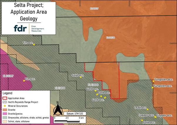
Figure 1: New Exploration Licence Application, Selta Project, Northern Territory, Australia
References
1 Geophysics and Drilling Collaborations (GDC) is a competitive grants programme funded by the Northern Territory Government’s $9.5 million per annum Resourcing the Territory programme and is administered by the Northern Territory Geological Survey (NTGS). For more information see https://resourcingtheterritory.nt.gov.au/gdc
For further information visit www.firstdevelopmentresources.com or contact the following:
|
First Development Resources plc Tristan Pottas (CEO) |
Tel: +44 (0) 20 3778 1397 |
|
Beaumont Cornish Limited Nominated Adviser Roland Cornish / Asia Szusciak |
Tel: +44 (0) 20 7628 3396 |
|
SI Capital Limited Broker Nick Emerson
|
#FDR First Development Resources PLC – Selta Project – Gold exploration update
First Development Resources plc (AIM: FDR), a UK-based, Australia-focused mineral exploration company with interests in Western Australia and the Northern Territory, is pleased to provide an update on its gold (“Au”) focused exploration at the Selta Project (“Selta” or the “Project”), located in the Aileron Province of Australia’s Northern Territory.
HIGHLIGHTS
· The high-resolution aeromagnetic (“AMAG”) and radiometric (“RAD”) geophysical survey over the Lander West regional gold target area has been successfully completed, covering approximately 4,200-line kilometres and delivering a high-quality geophysical survey dataset for targeting Au.
· Updated AMAG / RAD images are being interpreted, enhancing FDR’s understanding of subsurface geology, structures, and alteration patterns for drill targeting gold mineralisation associated with anomalous surface geochemical and historical shallow drilling results.
· These new airborne geophysical survey results will be integrated with ongoing Gradient Array Induced Polarisation (“GAIP”) survey results and historical geochemistry from surface sampling and shallow drilling to refine and prioritise target zone for future drilling.
· Planning and applications for land access and heritage approvals over target areas is currently underway.
Tristan Pottas, Chief Executive Officer of FDR, commented:
“Completion of the high-resolution AMAG and radiometric survey at Lander West represents a major step forward and it has materially improved our understanding of the subsurface geology and structural controls on mineralisation. We are grateful for the support received from Thomson Airborne, who delivered a high-quality, professional dataset on schedule over the holiday period.
The integration of the AMAG / RAD data with results from the ongoing GAIP survey and historical geochemical information will allow us to systematically refine and prioritise gold drill targets. We are very pleased with the quality of the datasets delivered and look forward to advancing Lander West through the next phase of exploration.”
AMAG / RAD SURVEY OUTCOMES
The completed AMAG / RAD survey was flown by Thomson Airborne Pty Ltd in early January 2026 using 100m spaced flight lines to generate high-resolution magnetic and radiometric datasets along approximately 4,200-line kilometres. The survey has delivered detailed imaging of structural features, lithological boundaries, and alteration signatures across the Lander West gold target area.
A comparison between the original regional airborne magnetic anomaly imagery and the new FDR acquired high-resolution AMAG imagery is provided in Figure 1 (original) and Figure 2 (newly acquired imagery). The new AMAG survey data have been processed to provide very detailed imagery on the subsurface geology and structure that will help FDR’s technical team to better constrain structures of interest for drill targeting Au mineralisation.
Figure 2 presents the First Vertical Derivative (“1VD”) of Total Magnetic Intensity reduced to magnetic pole (TMI RTP) filtered anomaly image. Additional data processing methods and three-dimensional (“3D”) inversion modelling results are being reviewed to identify areas of granitic intrusive contacts with meta-sediments and meta-volcanic host rocks, zones of folding and faulting, and hydrothermal alteration zones, which are key targeting criteria for potential gold mineralisation.
The newly acquired AMAG / RAD data results will be integrated with chargeability and resistivity information generated from the ongoing GAIP geophysics survey to better constrain and target potential mineralised zones at depth for follow up air-core (“AC”) drilling transects to test shallow targets and reverse circulation (“RC”) drilling to test deeper GAIP targets and drill under historical shallow Au anomaly zones. This combined geophysical interpretation, together with historical geochemical datasets, will underpin a robust, multi-disciplinary targeting framework to identify and prioritise drill-ready gold targets.
LANDER WEST GOLD TARGET
Following detailed desktop studies, FDR has identified the Lander West regional gold target area as a priority focus within the broader Selta Project. This target has been supported by a comprehensive gold targeting study completed by Resource Potentials Pty Ltd (“ResPot”), a Perth, Western Australia-based Mineral Exploration and Geophysical Consultancy. ResPot has been commissioned to integrate historical drilling, geological, geophysical, and geochemical datasets to help FDR define high-potential gold targets for follow-up work.
Lander West is interpreted as a continuation of the Stafford Gold Trend, where the adjacent ground hosts high-grade gold and antimony (“Sb”) mineralisation in the same geological units extending to the southeast (1). Gold mineralisation is believed to be shear-hosted, associated with zones of deformation and hydrothermal alteration, which produce subtle but measurable variations in magnetic response. Within Lander West, a very large granitic batholith, with smaller granite stocks along its margin, have been identified by the AMAG data to sit below thin sand cover sediments, and these granites are a likely source for the Au (and Sb) mineralising fluids to form Intrusive Related Gold (“IRG”) and skarn type gold targets with FDR’s land holding. High-resolution geophysical datasets are therefore critical to refining drill targets and advancing FDR’s gold exploration programme.
NEXT STEPS
Interpretation and 3D inversion modelling of the integrated AMAG / RAD, GAIP survey results and geochemical datasets is underway, and the result is already informing key areas for follow-up exploration planning, including the design and prioritisation of future AC and RC drilling programmes at Lander West. This systematic, data-driven approach is intended to maximise discovery potential while maintaining a disciplined and cost-effective exploration strategy over such a large gold target area.
Further updates will be provided as interpretation progresses and exploration activities advance.
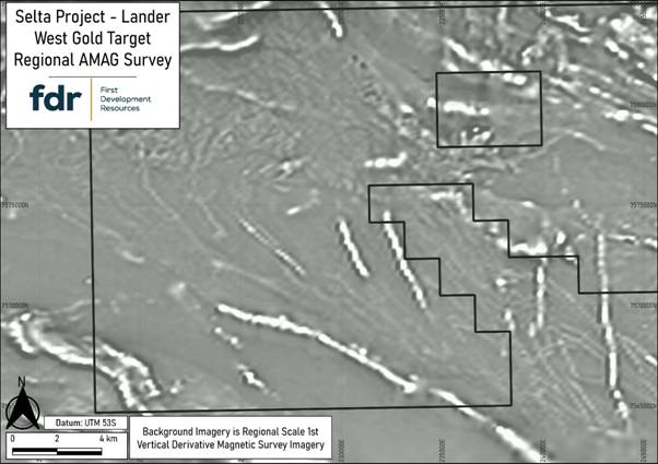
Figure 1: Original regional scale AMAG data anomaly image (1VD filtered and grey colour scale) from the Selta Project Lander West gold target area.
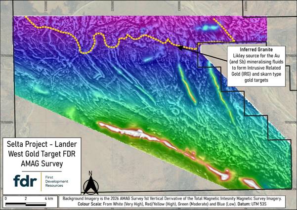
Figure 2: Newly-acquired first vertical derivate (1VD) on total magnetic intensity (TMI) filtered AMAG anomaly imagery from the Selta Project Lander West gold target area. This processing method helps sharpen shallow geological effects, such as fault systems, folds and shear zones, and it clearly identified a newly discovered granite contact in the north, which is a likely driver for hydrothermal fluids and heat to produce Au mineralisation.
REFERENCE
1. iTech Minerals Ltd (ASX: ITM) announcement dated 12 January 2026
(2924-03045120-2A1647835&v=undefined)
QUALIFIED PERSON STATEMENT
The technical information contained in this disclosure has been reviewed and approved by Mr Nicholas O’Reilly (MSc, DIC, MIMMM QMR, MAusIMM, FGS), who is a qualified geologist and acts as the Qualified Person under the AIM Rules – Note for Mining and Oil & Gas Companies. Mr O’Reilly is a principal consultant working for Mining Analyst Consulting Ltd which has been retained by First Development Resources plc to provide technical support.
GLOSSARY
|
Term |
Definition |
|
3D Inversion Modelling |
A technique that converts geophysical survey data into a three-dimensional (3D) map of underground structures, highlighting areas likely to host minerals. |
|
Aeromagnetic (AMAG) survey |
An airborne geophysical survey that measures variations in the Earth’s magnetic field to map subsurface geology and structures. |
|
Air-Core (AC) Drilling |
A drilling method for sampling shallow rocks efficiently, commonly used in early-stage exploration. |
|
Alteration patterns |
Recognisable changes in rocks caused by hot fluids moving through them, which can help indicate where valuable minerals may be concentrated. |
|
Chargeability information (GAIP Survey) |
Measures how strongly subsurface rocks hold an electric charge after introducing an electrical transmitter current into the ground, helping identify zones with disseminated sulphide minerals linked to gold. |
|
First Vertical Derivative (1VD) |
A magnetic data filter processing technique that calculates the rate of change of the magnetic field with height, enhancing short-wavelength anomalies and sharpening the edges of magnetic anomalies related to geological contacts, alteration zones, faults, and shear zones. |
|
Geochemical information |
Chemical data from rocks, soils, or fluids that is used to identify and understand areas with potential mineral deposits. |
|
Geophysical survey |
A method of measuring physical property changes in the Earth, such as magnetism, gravity, or electrical conductivity, to identify subsurface geological rock units, structures and potential mineral deposits. |
|
Gradient Array Induced Polarisation (GAIP) survey |
A geophysical survey method that maps anomalies caused by subsurface geology and mineralisation by measuring electrical properties of the ground. GAIP helps identify and prioritise prospective gold targets for follow-up exploration and drilling. |
|
Granitic Batholith |
A large underground granite body often associated with mineral deposits. |
|
High-resolution (AMAG Survey) |
Refers to geophysical data collected at closely spaced intervals (100m or less), providing detailed and precise information about subsurface magnetic features to improve target definition for exploration. |
|
Hydrothermal alteration |
Changes in rock caused by hot, mineral-rich fluids, often forming new minerals and altering the rock’s original composition. |
|
Intrusive Related Gold (IRG) |
Gold associated with igneous intrusions, commonly forming structurally controlled or disseminated deposits. |
|
Line Kilometre |
One kilometre of a geophysical survey line flown or surveyed. Total line kilometres indicate the survey’s overall coverage. |
|
Lithological boundary |
The contact or transition between different rock types, which can influence how fluids move and where minerals may accumulate. |
|
Metasediments |
Sediment-based rocks that have been metamorphosed, often forming targets for mineral exploration. |
|
Meta-volcanic host rocks |
Volcanic rocks altered by heat or pressure that host or control the formation of mineral deposits. |
|
Mineralisation |
The process by which valuable minerals are formed and concentrated in rocks, creating zones that may be mined for metals or other resources. |
|
Radiometric (RAD) survey |
Measures natural gamma radiation from rocks and regolith related to potassium (K), thorium (Th) and uranium (U) concentrations in the surface outcrop to highlight areas altered by minerals, helping pinpoint potential gold and other deposits. |
|
Resistivity information (GAIP Survey) |
Measures how strongly subsurface rocks resist electrical current, helping map geological rock units, structures, sulphide mineralisation and hydrothermal alteration zones |
|
Reverse-Circulation (RC) Drilling |
A standard exploration drilling approach that produces clean samples for assessing mineral deposits. |
|
Shear hosted |
Describes a rock or mineral deposit that occurs within, and is controlled by, a shear zone, where deformation created pathways for hydrothermal fluids and mineral deposition. |
|
Shear zone |
A zone of intense deformation where rocks have been sheared and fractured, often hosting gold due to the increased porosity formed along the shear zone. |
|
Skarn-Type Gold Targets |
Gold deposits formed where igneous intrusions alter carbonate rocks, creating mineral-rich zones. |
|
Stafford Gold Trend |
A regionally significant mineralised corridor in the Northern Territory, Australia, known for hosting gold and high-grade antimony deposits, which provides structural and geological continuity for exploration targets like Lander West. |
|
Structural feature |
A geological break or deformation in rocks such as faults, shear zones, or folds. |
|
Subsurface geology |
The type, structure, and arrangement of rocks below the Earth’s surface that help explain how mineral deposits may have formed. |
|
Total Magnetic Intensity (TMI) |
The measured strength of the Earth’s magnetic field at a location, including contributions from both the regional geomagnetic field and local magnetic variations caused by subsurface geology. |
|
Zone of deformation |
An area of rock altered or deformed by stress, such as faulting or folding. |
For further information visit www.firstdevelopmentresources.com or contact the following:
|
First Development Resources plc Tristan Pottas (CEO) |
Tel: +44 (0) 20 3778 1397 |
|
Beaumont Cornish Limited Nominated Adviser Roland Cornish / Asia Szusciak |
Tel: +44 (0) 20 7628 3396 |
|
SI Capital Limited Broker Nick Emerson |
Tel: +44 (0) 1483 413 500 |
#FDR First Development Resources – Paterson Province – Applications for New Licences
First Development Resources plc (AIM: FDR), the UK-based, Australia-focused exploration company with mineral interests in Western Australia and the Northern Territory, is pleased to announce that it has applied for three new Exploration Licences in the Paterson Province of Western Australia.
The new applications, E45/7205, E45/7206 and E45/7207, are located immediately to the east of the Company’s existing Wallal Project licences (Figure 1) and cover ground previously held by Rio Tinto Exploration.
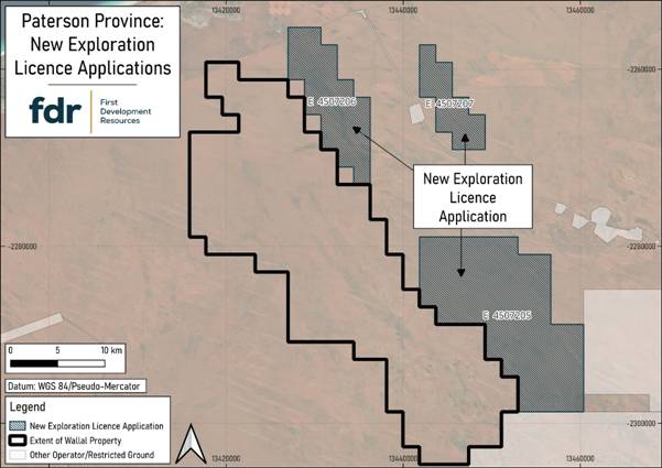
Figure 1: FDR’s New Exploration Licence applications pending approval. Paterson Province, Western Australia
The statutory objection period under the Mining Act 1978 (WA) for the new licences closed on 12 and 13 January 2026, and the Company confirms that no objections were lodged in that statutory period.
The licence applications are now being assessed by the Department of Mines, Petroleum and Exploration (DMPE) in Western Australia to ensure compliance with all regulatory requirements, including environmental and land use considerations.
In parallel, FDR is engaging with relevant Traditional Owner groups as part of the Aboriginal Heritage Act and Native Title Act consultation process to ensure that exploration activities respect cultural heritage.
Any future exploration work will only proceed once all statutory approvals, including relating to Native Title and heritage clearances, have been secured.
Once granted, these licences will further consolidate FDR’s strategic land position in the highly prospective Paterson Province and enhance the Company’s exploration footprint in the region. The Company looks forward to advancing exploration planning in a responsible and compliant manner.
For further information visit www.firstdevelopmentresources.com or contact the following:
|
First Development Resources plc Tristan Pottas (CEO) |
Tel: +44 (0) 20 3778 1397 |
|
Beaumont Cornish Limited Nominated Adviser Roland Cornish / Asia Szusciak |
Tel: +44 (0) 20 7628 3396 |
|
SI Capital Limited Broker Nick Emerson |
Tel: +44 (0) 1483 413 500 |
Beaumont Cornish Limited (“Beaumont Cornish”) is the Company’s Nominated Adviser and is authorised and regulated by the FCA. Beaumont Cornish’s responsibilities as the Company’s Nominated Adviser, including a responsibility to advise and guide the Company on its responsibilities under the AIM Rules for Companies and AIM Rules for Nominated Advisers, are owed solely to the London Stock Exchange. Beaumont Cornish is not acting for and will not be responsible to any other persons for providing protections afforded to customers of Beaumont Cornish nor for advising them in relation to the proposed arrangements described in this announcement or any matter referred to in it.
ABOUT FIRST DEVELOPMENT RESOURCES
First Development Resources’ assets comprise eight granted tenements covering a total area of 2,314.4km2. Five of the tenements, comprising three prospective copper-gold projects, are located in Western Australia (WA) while the remaining three tenements, comprising a rare-earth element (REE), uranium, lithium and gold project, are located in the Australian’s Northern Territory. All tenements are wholly owned by FDR. The assets are a mixture of drill ready and earlier stage exploration.
The WA Projects include the Company’s Wallal Project as well as Ripon Hills and Braeside West Projects situated in the Paterson Province, which is widely regarded as one of the most productive regions in Australia for the discovery of world-class gold-copper deposits, and which is home to several world-class mines and more recent discoveries.
The Selta Project in the Northern Territory is located in an area considered highly prospective for uranium and rare-earth element mineralisation along with base and precious metal mineralisation. Numerous companies are actively exploring within the region.
Beyond the existing portfolio, FDR is actively looking to expand its portfolio through the acquisition of early-stage exploration projects in Australia.
#SVML Sovereign Metals Limited – Notice of General Meeting
 Sovereign Metals Limited (ASX:SVM; AIM:SVML; OTCQX:SVMLF) (Sovereign or the Company) advises that a General Meeting (Meeting) of shareholders will be held on Wednesday, 18 February 2026 at 11:00am (AWST) at the Conference Room, Ground Floor, 28 The Esplanade, Perth, Western Australia 6000.
In accordance with 110D of the Corporations Act 2001 (Cth), the Company will not be dispatching physical copies of the Notice of Meeting (unless a shareholder has elected to receive documents in hard copy in accordance with the timeframe specified in section 110E(8) of the Corporations Act 2001 (Cth)).
A copy of the Notice of Meeting can be viewed and downloaded online as follows:
· the Company’s website: https://sovereignmetals.com.au/asx-announcements/.
· the Company’s ASX Market announcements page at www.asx.com.au under the Company’s ASX code “SVM”; or
· if you have provided an email address and have elected to receive electronic communications from the Company, you will receive an email to your nominated email address with a link to an electronic copy of the Notice of Meeting.
The Company intends to hold a physical meeting. The Company will notify shareholders of any changes to this Meeting by way of an announcement on ASX, AIM and OTCQX and the details will also be made available on our website.
The Notice of Meeting is important and should be read in their entirety. If you are in doubt as to the course of action you should follow, you should consult your stock broker, investment advisor, accountant, solicitor or other professional adviser.
You may also, prior to the Meeting, obtain a paper copy of the Notice of Meeting (free of charge) by contacting the Company Secretary on +61 8 9322 6322 or by sending an email to info@sovereignmetals.com.au.
Holders of Depositary Interests should complete and sign a Form of Instruction, which will be sent separately to each Holder of Depositary Interests, and return it by the time and in accordance with the instructions set out in the Form of Instruction. Holders of Depositary Interests will not be eligible to vote in person at the Meeting.
How do I update my communications preferences?
Shareholders can still elect to receive some or all of their communications in physical or electronic form or elect not to receive certain documents such as annual reports. To review your communications preferences, or sign up to receive your shareholder communications via email, please update your communication preferences with Computershare at https://www-au.computershare.com/Investor/#Home.
|
Enquiries |
|
Dylan Browne Company Secretary +61 8 9322 6322 |
|
Nominated Adviser on AIM and Joint Broker |
|
|
SP Angel Corporate Finance LLP |
+44 20 3470 0470 |
|
Ewan Leggat Charlie Bouverat |
|
|
|
|
|
Joint Broker |
|
|
Stifel |
+44 20 7710 7600 |
|
Varun Talwar |
|
|
Ashton Clanfield |
|